
Beyond the Flat Earth: Navigating the Non-Euclidean Geometry of AlphaEarth Embeddings
Characterizing AlphaEarth Embedding Geometry for Agentic Environmental Reasoning
The paper characterizes the geometric structure of Google AlphaEarth's 64-dimensional satellite foundation model embeddings across 12.1 million US samples. It introduces an agentic geospatial intelligence system that utilizes this manifold understanding via specialized tools to perform multi-step environmental reasoning.
TL;DR
Researchers have mapped the "internal geography" of Google's AlphaEarth embeddings, revealing a complex, curved manifold rather than a flat vector space. While traditional vector arithmetic (like the famous King - Man + Woman = Queen) fails in this geospatial domain due to high curvature, a new agentic system using "geometry-aware" tools allows LLMs to perform sophisticated, multi-step environmental reasoning with unprecedented grounding.
The Problem: The "Linearity Trap" in Geospatial AI
In the world of NLP, we’ve grown accustomed to the idea that embedding spaces are somewhat linear—that there are "directions" for gender, tense, or sentiment. However, the Earth is not a dictionary. Satellite foundation models (SFMs) compress multispectral data into dense vectors, but many researchers treat these 64D or 512D spaces as simple Euclidean boxes.
The authors of this paper argue that this is a mistake. If the manifold is curved, a "precipitation direction" in Kansas won't be the same as a "precipitation direction" in the Cascades. This "tangent space rotation" makes simple vector math physically incoherent, leading to "hallucinated" environments when researchers try to manipulate embeddings algebraically.
Methodology: Mapping the Manifold
To solve this, the team performed a massive-scale geometric audit of 12.1 million AlphaEarth samples across the Continental US (CONUS).
1. Characterizing Complexity
Using the Participation Ratio (PR) and Maximum Likelihood Estimation (MLE), they discovered that while the ambient space is 64D, the data actually lives on a ~10D to 13D manifold. Crucially, this manifold is "folded."
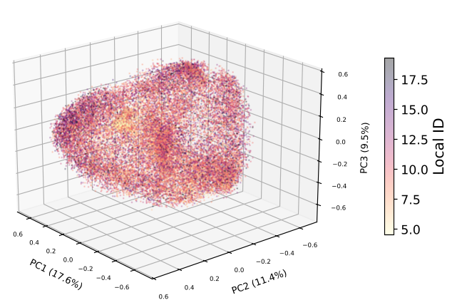 Figure 3: 3D PCA projection showing how local intrinsic dimensionality correlates with topographic complexity.
2. The Agentic Architecture
Instead of a fixed pipeline, they built a ReAct agent (using Claude Sonnet 4.5/Opus 4.6). The breakthrough is the toolset: the agent doesn't just "search"; it uses tools like assess_retrieval_confidence and get_regional_profile to understand the geometry of its current "location" in the embedding space before it trusts the data.
Experimental Battleground: Retrieval vs. Arithmetic
The results were stark. The authors tried to perform "environmental analogies" (e.g., "What is location X but with the rain of location Y?").
- Arithmetic (FAIL): Even with supervised linear probes, the "concept directions" rotated so much across the US (mean alignment only 0.17) that the math produced nonsense.
- Retrieval (WIN): Direct retrieval from a FAISS-indexed database remained physically coherent. The agent learned to "walk" the manifold via retrieval rather than trying to "jump" across it with math.
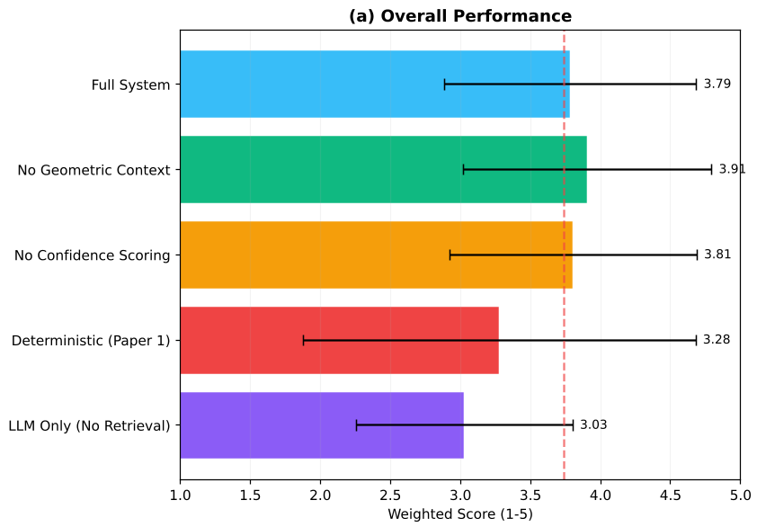 Figure 9: The agentic system shines in Tier 2 (Multi-step comparison), where deterministic pipelines are powerless.
Key Insight: The "Planning Tax" on Weaker Models
One of the most fascinating findings is the Cross-Model Benchmark. The authors found that providing geometric metadata is a double-edged sword:
- Claude Sonnet 4.5 (a mid-tier frontier model) struggled with the complexity, showing a slight performance drop because the extra geometric tools made planning too difficult.
- Claude Opus 4.6 (the more capable model) actually improved, referencing geometric uncertainty (like confidence scores) to provide more nuanced, grounded answers.
Conclusion: A New Blueprint for Geospatial Intelligence
The takeaway for the AI community is clear: Satellite embeddings are not words. Their spaces are curved, heterogeneous, and deeply tied to physical geography.
- Stop doing vector arithmetic on SFM embeddings—it’s physically unreliable.
- Invest in Agentic RAG: Use LLMs to plan multi-step retrievals that respect the local geometry.
- Capability Matters: As we move toward more powerful models, providing "system-level" metadata (like manifold curvature or retrieval confidence) will become the primary way to reduce hallucinations in geospatial tasks.
This work moves us closer to "Geospatial General Intelligence," where agents don't just look at maps—they understand the underlying mathematical fabric of the Earth itself.