
DINO Soars: Redefining Remote Sensing Segmentation Without a Single Satellite Image
DINO Soars: DINOv3 for Open-Vocabulary Semantic Segmentation of Remote Sensing Imagery
This paper introduces CAFe-DINO, a novel framework for Open-Vocabulary Semantic Segmentation (OVSS) in Remote Sensing (RS). By combining the DINOv3 backbone with a cost aggregation network and a training-free upsampler (AnyUp), the model achieves State-of-the-Art (SOTA) performance on major RS benchmarks without requiring any pre-training or fine-tuning on actual satellite imagery.
TL;DR
Remote Sensing (RS) has long struggled with the "data desert" of dense labels. CAFe-DINO shatters the requirement for domain-specific training by leveraging the massive representational power of DINOv3. By combining cost aggregation with universal feature upsampling, it achieves SOTA results on satellite benchmarks while being trained exclusively on natural images.
The Motivation: Escaping the RS Data Trap
Traditional Remote Sensing models are often trapped in a cycle: to perform well on satellite data, they must be trained on satellite data. However, satellite labels are expensive and sparse.
Current Open-Vocabulary Semantic Segmentation (OVSS) models, mostly based on CLIP, struggle with the "nadir" (top-down) view and unique spectral signatures of RS imagery. The authors of CAFe-DINO realized that DINOv3, trained on over 1 billion natural images, possesses a latent robustness that captures spatial structures so well it transcends the domain gap—if only its zero-shot "noise" could be cleaned up.
Methodology: Refining the "Cost" of Recognition
The CAFe-DINO architecture (Cost Aggregation + Feature Upsampling with DINO) operates on a three-stage pipeline:
- Alignment (DINOv3.txt): An image is fed into the DINOv3 vision backbone, while class names (e.g., "pavement", "water") are fed into an aligned text encoder. This creates a low-resolution "cost volume"—essentially a stack of heatmaps showing where the model thinks each class is located.
- Aggregation (The Brain): Raw cost maps are often noisy. CAFe-DINO uses a series of Swin Transformer and Channel Attention blocks to let classes "talk" to each other. If the model sees "cars," it likely infers the surrounding grey pixels are "road," even if the raw road signal was weak.
- Upsampling (The Eyes): Standard CNN decoders often overfit to the training domain. Instead, the authors use AnyUp, a training-free universal upsampler that uses the high-resolution input image as a guide to sharpen the low-resolution features back to original size.
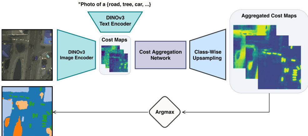 Figure 1: The CAFe-DINO pipeline, showing how cost maps are projected, aggregated, and upsampled.
The "Natural" Training Secret
One of the paper's most radical moves is its training regime. Instead of using satellite datasets, they used COCO-Stuff (natural photos of cats, buses, and kitchens). However, they meticulously selected a subset of 41 RS-relevant classes (e.g., "grass," "building," "bridge") and ignored the rest. This "RS-targeted" natural training proved more effective than random sampling, providing a bridge between common objects and satellite views.
Results: Dominating the Benchmarks
The results are striking. On the ISPRS Potsdam dataset, CAFe-DINO reached an mIoU of 66.8%, dwarfing the previous RS-trained SOTA of 52.0%.
 Table 1: Performance comparison. CAFe-DINO (bottom row) consistently outperforms models that were actually trained on RS data.
Visual Insight: Turning Noise into Knowledge
As shown in Figure 5 of the paper, the raw DINOv3 cost maps for classes like "Low Vegetation" are almost unintelligible. After the aggregation process, CAFe-DINO produces sharp, accurate boundaries.
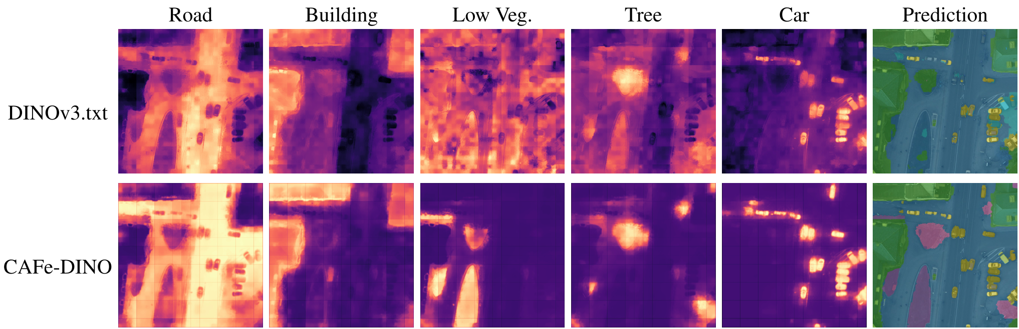 Figure 2: Top row shows raw DINOv3 maps; bottom row shows CAFe-DINO's refined, aggregated output.
Critical Analysis & Conclusion
The Takeaway: CAFe-DINO proves that the "Inductive Bias" of large-scale foundation models is becoming strong enough to ignore domain-specific fine-tuning, provided we use the right "refiners" (like cost aggregation).
Limitations:
- Memory Complexity: Memory usage grows linearly with the number of classes, which might limit extremely large vocabularies (e.g., thousands of plant species).
- Rural Texture Confusion: The model still occasionally confuses visually similar textures like "grass" and "crops." This is likely because natural image datasets (like COCO) don't distinguish between these as strictly as satellite datasets do.
Future Outlook: By integrating multi-spectral data (beyond RGB) into the DINOv3 framework, we could likely solve the texture confusion, creating a truly "universal" observer for Earth monitoring.