
[CVPR 2025] HTNav: Overcoming the Long-Range Hurdles in Urban Aerial Navigation
HTNav: A Hybrid Navigation Framework with Tiered Structure for Urban Aerial Vision-and-Language Navigation
The paper introduces HTNav, a hybrid aerial Vision-and-Language Navigation (VLN) framework that combines Imitation Learning (IL) and Reinforcement Learning (RL) with a tiered decision-making architecture. It achieves State-of-the-Art (SOTA) results on the CityNav benchmark, notably increasing the Success Rate (SR) from 9.70% to 25.49% on the Test Unseen split.
TL;DR
Navigating a drone through a complex city using only natural language instructions (e.g., "fly to the red car near the library") is a daunting task involving spatial reasoning, visual perception, and long-term planning. HTNav tackles this by introducing a Hybrid IL-RL framework and a Tiered Decision Mechanism. By splitting the task into "where to go next" (Macro) and "how to move" (Micro), and refining the CityNav dataset, the authors set a new SOTA, doubling the success rates of previous baselines.
Background: Why Aerial VLN is Hard
Unlike indoor VLN where agents move between discrete nodes in a graph, aerial VLN in urban environments like the CityNav benchmark requires continuous movement across vast distances. Current models face three "walls":
- Generalization Gap: Performance drops sharply in "Unseen" cities.
- The Long-Range Trap: Errors in small steps accumulate, causing the drone to drift miles away from the target.
- Spatial Blindness: Standard encoders often fail to grasp the "continuity" of a city's layout.
Methodology: The "Brain" and "Muscle" Decomposition
1. The Staged Training Strategy (IL + RL)
HTNav doesn't start from scratch with Reinforcement Learning. It uses a two-stage pipeline:
- Stage 1 (Imitation Learning): The model learns the "basics" from expert demonstrations, specifically training a Value Prediction Head.
- Stage 2 (PPO Fine-tuning): The RL stage uses the weights from Stage 1. This "guided exploration" prevents the drone from wandering aimlessly and allows the policy to transcend the limitations of the training data.
2. Tiered Decision-Making
Instead of a single network predicting the next move, HTNav splits the labor:
- MacroPlanner: Acts as the "strategist." It looks at the semantic map and landmarks to generate intermediate waypoints.
- MicroActor: Acts as the "pilot." It looks at the immediate RGB-D feed and the current waypoint to execute one of six discrete actions (Turn left, Forward, etc.).
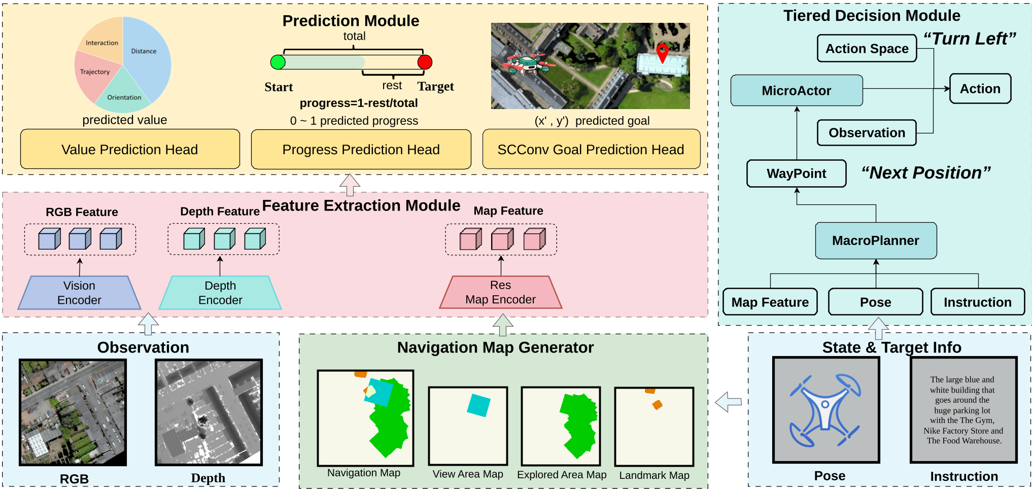 Figure 1: The HTNav architecture, featuring tiered decision-making and multi-task prediction heads.
3. Map Representation Learning
The authors introduced a Residual Map Encoder combined with SCConv (Spatial and Channel reconstruction Convolution). This module is designed to suppress redundant features in the semantic map—like repetitive road textures—while highlighting critical landmarks.
Experiments and Results
The authors didn't just build a model; they cleaned the data. By correcting 800+ errors in the CityNav landmark annotations, they provided a more robust ground truth.
HTNav was tested against heavyweights like FlightGPT and AerialVLN. On the most difficult "Test Unseen" split:
- Success Rate (SR): 25.49% (vs. MGP's 9.70% and FlightGPT's 24.47%).
- Navigation Error (NE): Reduced to 40.3m.
- Efficiency (SPL): Reached 21.56, signifying much cleaner paths than previous methods.
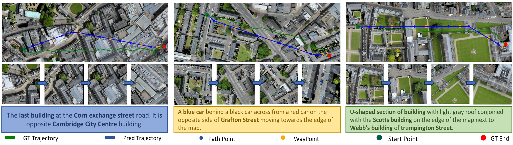 Figure 2: HTNav's trajectory (Green) stays remarkably close to the Ground Truth (Blue), even in long-path scenarios.
Critical Insight: The Value of Landmarks
A key takeaway from the ablation studies is the power of landmark maps. When the authors removed the landmark map feature, the Success Rate plummeted from 28.30% to a mere 1.86%. This proves that for urban-scale navigation, high-level "spatial anchors" (knowing where the library is relative to the park) are far more important than raw visual pixels.
Conclusion & Limitations
HTNav represents a significant leap in making UAVs "smarter" in the real world. However, the gap to human performance (which sits at ~87% Success Rate) remains massive. Future work will likely need to integrate even more powerful Vision-Language Models (VLMs) to handle the extreme ambiguity of natural language instructions in dense city environments.
Takeaway: If you want a robot to navigate a city, give it a map, teach it to plan waypoints, and let it refine its "instincts" through environment interaction.