
LLMAPID: Bridging the Gap Between Linguistics and Geography through Web-GIS
3432_Language and Location Map Annotation Project - A GIS-based infrastructure for linguistics information management.
The paper introduces LLMAPID (Language & Location Management and Analysis of Professional Information Data), a Geographic Information System (GIS) designed specifically for linguistic research. It integrates linguistic data with spatial, temporal, and cultural metadata to enable multi-dimensional analysis of language evolution and distribution.
TL;DR
LLMAPID is a specialized Geographic Information System (GIS) designed to transform how linguists manage and analyze data. By integrating linguistic information with spatial, temporal, and physical metadata, it allows researchers to visualize the complex relationships between language, culture, and the environment in a dynamic, web-based environment.
Background & Motivation: Why Space and Time Matter for Language
For decades, linguistic data was confined to static atlases and fragmented spreadsheets. However, language does not exist in a vacuum; it is shaped by geography (mountains, rivers), demographics (migrations), and time.
The core challenge identified by the authors is that existing linguistic databases often fail to provide spatial context. Previous efforts were either too simplified or too technical for the average linguist. There was a desperate need for a system that could handle:
- Direct Spatial Joining: Linking a language name to a specific coordinate on a globe.
- Dynamic Layering: Overlaying linguistic data with physical maps (altitude, precipitation) and social data (population density).
Methodology: The Architecture of LLMAPID
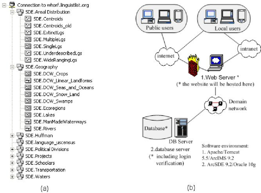
The system is built upon a robust relational database structure (RDBMS) integrated with a web interface. Its innovation lies in its ability to perform Dynamic Joining.
Core Components:
- ISO 639-3 Standardization: Every linguistic entry is mapped to a unique ISO code, ensuring interoperability with other global databases like Ethnologue or Multitree.
- Dynamic Joining Method: This allows the map to "talk" to different data layers—such as historical gazetteers or climate data—in real-time, creating a "composed map" that reveals hidden correlations.
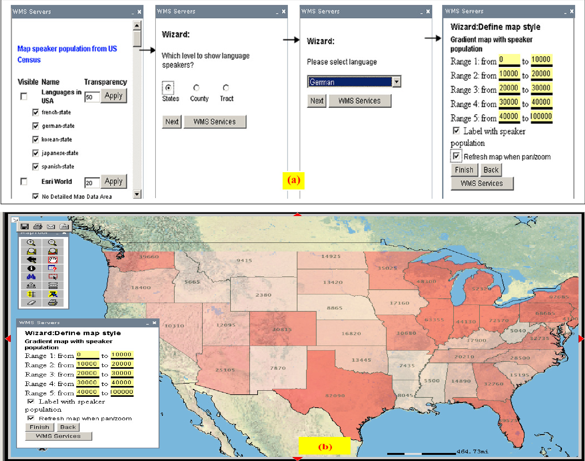
- The "Quick Map" Facility: A user-friendly tool that allows researchers to quickly search by language family, country, or region and instantly generate a spatial visualization.
Insights from Experiments: Toponyms and Endangered Languages
The paper highlights two powerful use cases for this architecture:
1. Toponymic Analysis (Place-Name Study)
By mapping place-names to physical geography, LLMAPID allows researchers to see how natural features (like "Black Water" or "Red Hill") are encoded into local languages, revealing how ancient populations perceived their environment.
2. Genetic and Historical Evolution
The system tracks the spread of language families over centuries. For example, researchers can overlay 18th-century "World Map" data with modern linguistic distributions to observe the impact of colonial expansion and migration on language survival.
Collaboration and Future Outlook
One of the most significant contributions of LLMAPID is its collaborative "Mark-up" tool. Unlike traditional "read-only" databases, LLMAPID allows experts worldwide to edit point data, add annotations, and contribute new layers of knowledge in real-time.
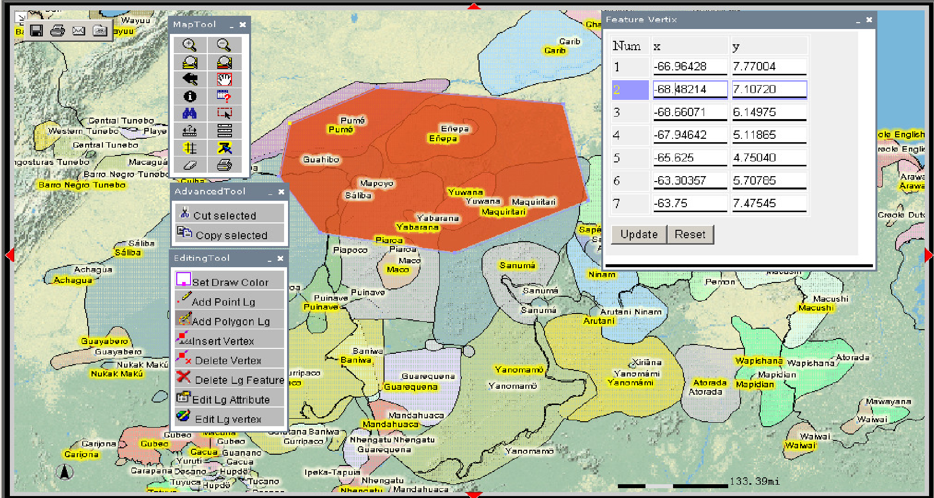
Summary of Impact:
- Integrated Knowledge: Combines scanned maps with live digital data.
- Accessibility: A web-based "zero-install" solution for the linguistic community.
- Interdisciplinary Potential: Opens doors for biologists, historians, and social scientists to use language as a proxy for human history.
Conclusion: LLMAPID isn't just a map maker; it's a discovery engine. By placing language back into its physical and temporal context, it provides the tools necessary for the next generation of digital humanities research.