
Beyond the Sky: Integrating Citizen Sensors into the Copernicus EO Ecosystem
10597_Potentials of Active and Passive Geospatial Crowdsourcing in Complementing Sentinel Data and Supporting Copernicus Service Portfolio.
This paper explores the integration of active and passive geospatial crowdsourcing ("citizen sensors") into the EU Copernicus program. It proposes a hybrid monitoring framework where in situ data from mobile devices complements Sentinel satellite data to enhance Earth Observation (EO) services.
TL;DR
While satellite programs like Europe's Copernicus offer unprecedented open access to Earth Observation (EO) data, they remain limited by physical and resolution constraints. This paper argues for the systematic integration of geospatial crowdsourcing—using the billions of smartphones globally as "citizen sensors"—to fill these gaps. The authors introduce CLOOPSy, a platform that leverages human-contributed ground data to validate Sentinel-based land maps, effectively turning the public into a massive, distributed validation network.
Contextualizing the "Citizen Sensor"
Historically, Earth monitoring was a top-down affair, relying on multi-million dollar satellites or specialized government-run ground stations. However, the rise of the "citizen scientist" has shifted the Inductive Bias of environmental monitoring. The authors position this work at the intersection of traditional remote sensing and Public Participation GIS (PPGIS), emphasizing that humans can provide "semantic intelligence" (e.g., identifying a specific crop type or building vulnerability) that satellites still struggle to resolve autonomously.
The Problem: Spectral Blind Spots and Temporal Gaps
Satellite data, including the Sentinel series, faces three primary hurdles:
- Occlusion: Building facades and underground biomass are often "invisible" to nadir-looking sensors.
- Resolution: Even High-Resolution (HR) imagery can be ambiguous in dense urban "anthropic" areas.
- Latency: Authoritative maps like CORINE Land Cover (CLC) are updated only every six years—a timeframe far too wide for monitoring rapid urbanization or deforestation.
Methodology: Active vs. Passive Geospatial Crowdsourcing
The authors categorize the "How" of citizen sensing into two distinct streams:
- Active (Participatory): Users knowledgeably "push" data via dedicated apps (e.g., CLOOPSy).
- Passive (Opportunistic): Pulling georeferenced "Ambient Geographic Information" (AGI) from existing repositories like Flickr, Instagram, or Twitter.
The CLOOPSy Framework
The core methodology presented is the CLOOPSy (Copernicus Land cOver crOwdsourcing Platform for Sentinel-based mapping) application. Unlike simple photo-sharing, CLOOPSy forces a structured interaction:
- Geotagged Photography: Capturing ground-level views.
- Taxonomic Labeling: Users select a category based on the CORINE taxonomy.
- Automatic Verification: A backend process intersects the report with GIS parcel data to ensure spatial consistency.
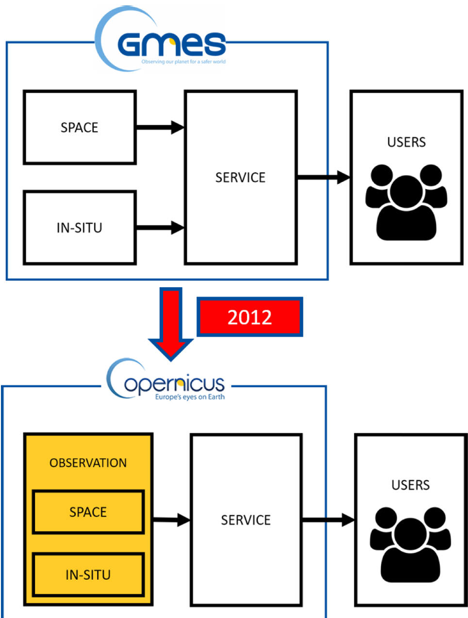 Figure: The evolution of the Copernicus structure to include in situ and crowdsourced data as a unified observation component.
Experiments and Results: Bridging the Ground-to-Space Gap
The research demonstrates how crowdsourced points act as Ground Control Points (GCPs) for training machine learning classifiers. By comparing CLOOPSy data with the official LUCAS (Land Use/Cover Area frame statistical Survey) database, the authors show that while LUCAS provides high quality, it lacks the temporal density that a crowd-based system provides.
The project utilizes a Django-based backend and PostGIS extension to handle the spatial data volume. A key technical insight is the use of Compass Direction in reports; by knowing which way a user was facing, the system can more accurately match the photo content to specific polygons in a satellite-derived map.
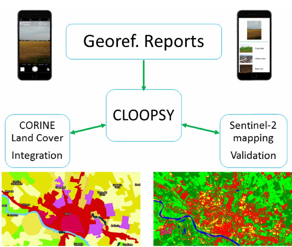 Figure: The data flow where user reports are validated and then ingested into the core land cover mapping service.
Critical Analysis: Quality vs. Quantity
The primary skepticism toward crowdsourcing is Reliability. The authors address this through:
- Ex-post Filtering: An administrative board (and eventually Deep Learning filters) reviews reports.
- Tutorial-based Onboarding: Users must complete training to ensure they understand the CLC taxonomy.
- Consensus Logic: Using spatial intersection to find "majority votes" across multiple citizen reports for the same land parcel.
Limitations
- Spatial Bias: Submissions are naturally clustered in populated or accessible areas, leaving remote regions unmonitored.
- Malicious Behavior: The "dumb filtering" of crowdsourced data is insufficient to stop coordinated misinformation, requiring more robust anomaly detection.
Conclusion and Future Outlook
This paper serves as a roadmap for the "operationalization" of crowdsourcing in EO. By moving from "playing with data" to becoming a formal subcomponent of the Copernicus architecture, citizen sensors provide a massive, real-time validation layer that satellites alone cannot match. For researchers, the next frontier lies in Information Fusion—creating algorithms that treat low-quality, high-frequency human data and high-quality, lower-frequency satellite data as parts of a single, coherent mathematical model.