
hackAIR: Revolutionizing Air Quality Monitoring via Multimodal Data Fusion
Towards Air Quality Estimation Using Collected Multimodal Environmental Data
The paper introduces the hackAIR platform, an open multimodal system designed to estimate air quality (specifically Particulate Matter - PM) by fusing data from official stations, low-cost DIY sensors, and user-generated social media imagery. By leveraging image processing and atmospheric radiative transfer models, it transforms casual sky photos into quantitative pollution metrics.
TL;DR
Air pollution is a silent killer, but official monitoring stations are too rare and expensive to provide localized data. The hackAIR platform bridges this gap by fusing official measurements with citizen science. Its "secret sauce" is turning every smartphone into a sensor: by analyzing the sky's color in social media photos and using low-cost DIY hardware, it creates a high-resolution map of air quality that official networks simply cannot match.
Background: The Granularity Gap
In environmental monitoring, we face a classic trade-off: Accuracy vs. Coverage. Official stations are extremely accurate but geographically sparse. Conversely, citizen data is abundant but noisy. Most existing apps (like Air Visual or World Air Quality) stick to one side of the fence. hackAIR positions itself as a multimodal bridge, integrating official data, low-cost sensors, and social media imagery into a unified indicator.
Problem & Motivation
Why do we need photos to measure air?
- Sensing Vacuums: Rural areas and specific urban micro-climates often lack official sensors.
- Cost Barriers: High-grade PM (Particulate Matter) sensors cost thousands of dollars.
- Engagement: Static data doesn't change behavior; active participation in data collection does.
The authors identified that human-generated content—specifically sky photos on Flickr or Instagram—contains latent physical information about atmospheric aerosols that can be extracted via computer vision.
Methodology: High-Tech Sensing from Low-Tech Sources
The system architecture is divided into three primary "ingestion" pipelines:
1. The Image Analysis Pipeline (The "Soft Sensor")
The most innovative component is the estimation of PM from images. The process follows a rigorous physics-based approach:
- Sky Detection: Using SIFT/SURF features or pre-trained CNNs to segment sky regions.
- Color Ratio Analysis: Calculating the R/G (Red-to-Green) ratio. Why? Because aerosols (pollution) scatter light; higher pollution levels typically shift the ratio towards the red spectrum.
- Model Matching: The system uses the SBDART (Santa Barbara DISTORT Atmospheric Radiative Transfer) model to map R/G ratios, Solar Zenith Angles (SZA), and Aerosol Optical Depth (AOD).
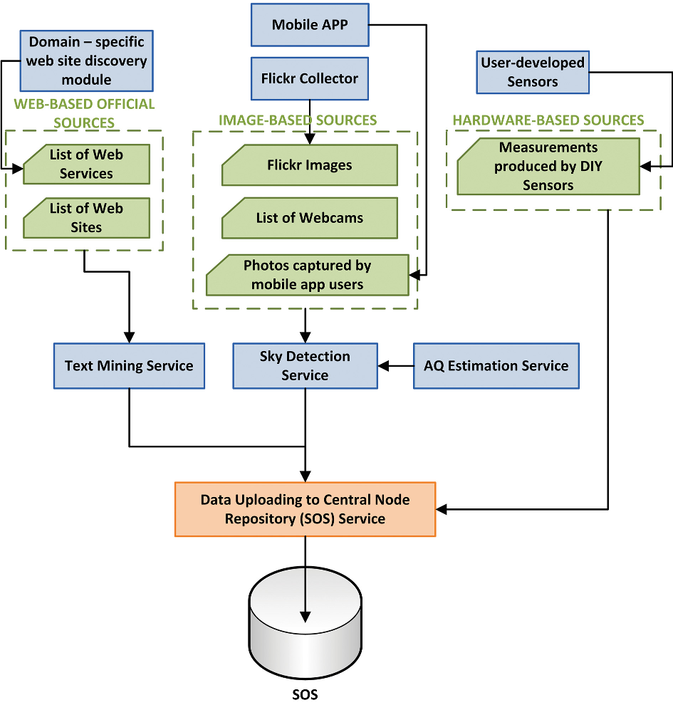 Figure 1: The hackAIR Architecture showing the fusion of Social Media, Web Services, and Open Hardware.
2. Hardware-Based Citizen Sensing
For users who want physical devices, hackAIR supports:
- Electronic Sensors: Arduino/PSoC 4 based PM sensors using Bluetooth Low Energy (BLE).
- Paper Filters: For the "less tech-savvy," a pump forces air through a filter. A photo of the darkened filter is then analyzed via blob detection algorithms to estimate PM concentrations.
Experiments and Comparative Landscape
The paper categorizes hackAIR against a vast landscape of existing initiatives. Unlike iSCAPE or CITI-SENSE which focus primarily on hardware, or AirTick which focuses only on photos, hackAIR's novelty lies in its inclusive fusion.
| Feature | Official Sources | Social Media Images | DIY Hardware |
|---|---|---|---|
| Reliability | High | Low/Medium | Medium |
| Coverage | Low | High | Medium |
| Cost | High | Zero | Low |
By combining these, the platform uses "Residual Kriging" (a geostatistical method) to fill in the gaps where official data is missing, using social media and DIY sensor data as the "residual" input.
Depth Insight: Why it Works
The physical intuition here is Mie Scattering. Larger particulate matter interacts differently with sunlight wavelengths. By using the R/G ratio at 550nm and 700nm, the researchers can effectively "reverse-engineer" the atmospheric turbidity. The brilliance is doing this with uncalibrated smartphone cameras by focusing on ratios rather than absolute luminance values, which are highly variable between device sensors.
Conclusion & Future Outlook
hackAIR represents a significant step toward Collective Environmental Awareness. While the current implementation relies on somewhat traditional image features (SIFT/SURF), the transition to Deep Learning (as mentioned in their sky detection module) promises even higher accuracy.
Limitations: The system's dependence on daylight (for sky photos) and the inherent noise in uncalibrated DIY sensors remain challenges. However, the use of Sensor Observation Service (SOS) ensures the platform is scalable and interoperable with future IoT standards.
The Takeaway? You don't need a million-dollar laboratory to map a city's air—you just need a community with smartphones and a smart fusion algorithm.