
Sensing the Soil: A Multi-Modal Approach to All-Terrain Estimation for Agricultural Robots
All-terrain estimation for mobile robots in precision agriculture
The paper introduces a multi-modal terrain classification system for agricultural robots that fuses exteroceptive data (stereo vision) with proprioceptive data (vehicle dynamics). Using a Support Vector Machine (SVM) classifier, the system achieves a state-of-the-art accuracy of 89.1% by identifying complementary features between visual appearance and physical vehicle-terrain interaction.
TL;DR
Autonomous agricultural vehicles often fail because they simply "look" at the ground without "feeling" it. This paper presents a robust framework that combines stereo vision with proprioceptive sensing (wheel slip, torque, and vibration). By fusing what the robot sees with how the vehicle reacts physically, the system achieves an 89.1% classification accuracy, solving the long-standing problem of visually similar but mechanically distinct terrains.
Problem & Motivation: The Limits of Sight
In precision agriculture, identifying the difference between a compacted dirt road and unploughed soil is critical for optimizing fuel consumption and preventing soil compaction. However, to a camera, these often look identical—both appear as "brownish soil."
The authors argue that Exteroceptive sensors (cameras, LiDAR) provide high-resolution "look-ahead" capability but are prone to lighting variations and "visual camouflage." Proprioceptive sensors, which measure the robot's internal state, provide the "ground truth" of mobility—how much is the wheel slipping? How much torque is required to move? The motivation here is complementarity: use vision to predict and proprioception to verify.
Methodology: Fusing Vision and Physics
The authors utilized a Husky A200 mobile platform equipped with a BumbleBee XB3 stereo camera and an array of internal sensors. The workflow follows a sophisticated two-step alignment:
- Exteroceptive Extraction: As the robot moves, it segments the terrain ahead into patches. It extracts Color Features (using the model to stay robust against lighting) and Geometric Features (slope, roughness, height variance from 3D point clouds).
- Proprioceptive Extraction: As the vehicle actually traverses that specific patch (tracked via Visual Odometry), it records:
- Motion Resistance (): Estimated from motor current and vertical load.
- Longitudinal Slip (): The difference between theoretical wheel speed and actual forward velocity.
- Vibrational Response: Vertical acceleration measured by the IMU.
- SVM Classification: These features are concatenated into a high-dimensional vector and fed into an SVM to categorize the ground into four classes: Ploughed, Unploughed, Dirt Road, or Gravel.
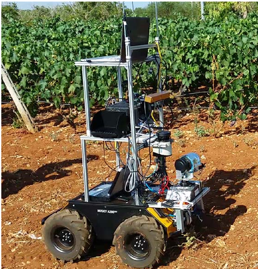 Figure 1: The Husky A200 robotic platform used for data gathering in vineyard and olive grove environments.
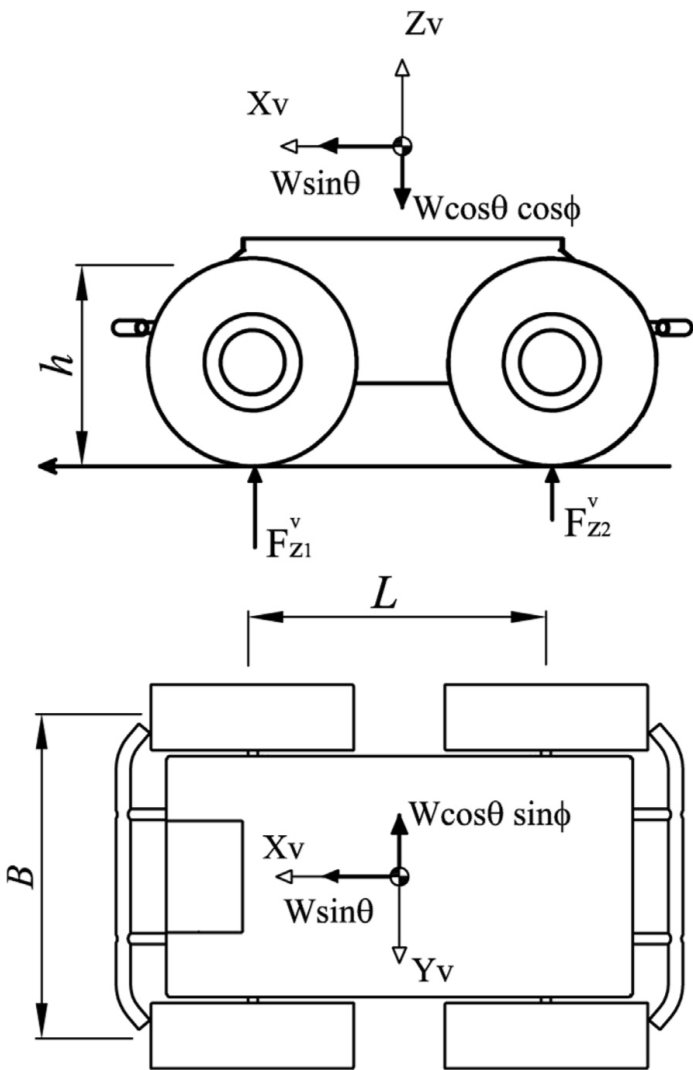 Figure 2: The physical model of motion resistance () used to calculate proprioceptive features.
Experiments & Results: Synergy in Action
The experimental results validate the core hypothesis: individual sensors have blind spots.
- Vision-only performed well on "ploughed" terrain due to its unique texture but struggled significantly with "dirt road" vs "unploughed terrain" (low precision).
- Geometric-only was the weakest performer (35.8% accuracy), likely due to the low resolution of stereo-reconstructed point clouds on relatively flat agricultural surfaces.
- The Fusion Advantage: By combining color and proprioception, the F1-score for the difficult "dirt road" class jumped significantly. The final model reached 89.1% total accuracy, a nearly 10% improvement over vision alone.
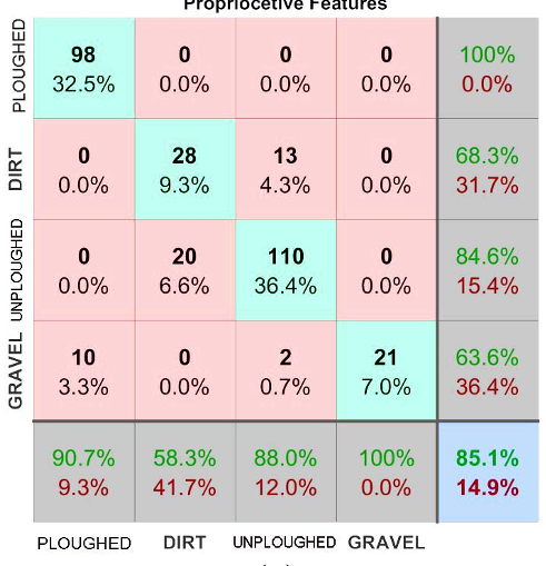 Figure 3: Confusion matrix showing the performance of the proprioceptive-based classifier (85.1%). The combined model (not shown in this specific table but discussed) pushes this further to 89.1%.
Critical Analysis & Conclusion
Takeaway
The real value of this work is the Multi-modal Terrain Map. Instead of just a 3D map, the robot generates "data layers"—essentially a "mobility map" that tells future farm management systems exactly where the ground is soft, where the wheels might slip, and where the soil is dangerously compacted.
Limitations & Future Work
- Hardware Constraints: The failure of geometric features suggests that for fine-grained terrain analysis, standard stereo vision may need to be replaced with high-density LiDAR.
- Temporal Delay: Proprioception is reactive. While it validates vision, the vehicle must "fail" (slip or vibrate) before it knows the terrain type. Future research should look into Self-Supervised Learning, where proprioceptive "ground truth" is used to automatically label visual data for better future predictions.
In conclusion, this paper bridges the gap between computer vision and classical vehicle dynamics, providing a blueprint for more "sensory-aware" robots in the demanding environments of modern agriculture.