
Breaking Language Barriers: A Mixed AR/VR Navigation System for Global Tourism
Development of AR/VR navigation system using non-linguistic information
This paper presents a hybrid AR/VR navigation system designed to assist tourists, particularly non-Japanese speakers, using non-linguistic information such as pictograms and symbols. The system integrates Web-GIS, SNS, and Twitter data to provide real-time, context-aware recommendations via smart glasses and mobile devices.
TL;DR
Language barriers remain one of the biggest hurdles in international tourism. This research introduces an innovative navigation framework that replaces complex text with non-linguistic information (symbols and pictograms). By blending Virtual Reality (VR) for pre-trip planning and Augmented Reality (AR) for real-time guidance, the system creates a seamless bridge between digital tourist data and the physical world.
The Problem: The "Lost in Translation" Syndrome
Despite the abundance of translation apps, foreign tourists still face significant "information anxiety." Traditional navigation systems are often:
- Language-Locked: Scaling a system to support dozens of languages via text is computationally and logistically expensive.
- Statistically Static: Most systems recommend popular spots but ignore real-time "buzz" or the user’s immediate physical context.
- Fragmented: There is a disconnect between the virtual research a tourist does and the actual physical navigation required on the street.
Methodology: The Fusion of VR and AR
The core of this paper lies in its Mixed Reality (MR) capability, supported by a robust backend of Web-GIS and Social Media integration.
1. The Virtual Layer (VR)
Using ESRI’s Web-GIS and 3D digital map data, users can "fly through" a 3D reconstruction of Yokohama. This allows for:
- Information Crowdsourcing: Users drop markers and photos directly onto a 3D manifold.
- Spatial Planning: Tourists can visualize their routes in a simulated environment before stepping outside.
2. The Physical Layer (AR)
Once on the move, the system shifts to Smart Glass technology (SONY SmartEyeglass). Instead of looking down at a phone, the user sees a "compass" and non-linguistic distance markers overlaid on their field of vision.
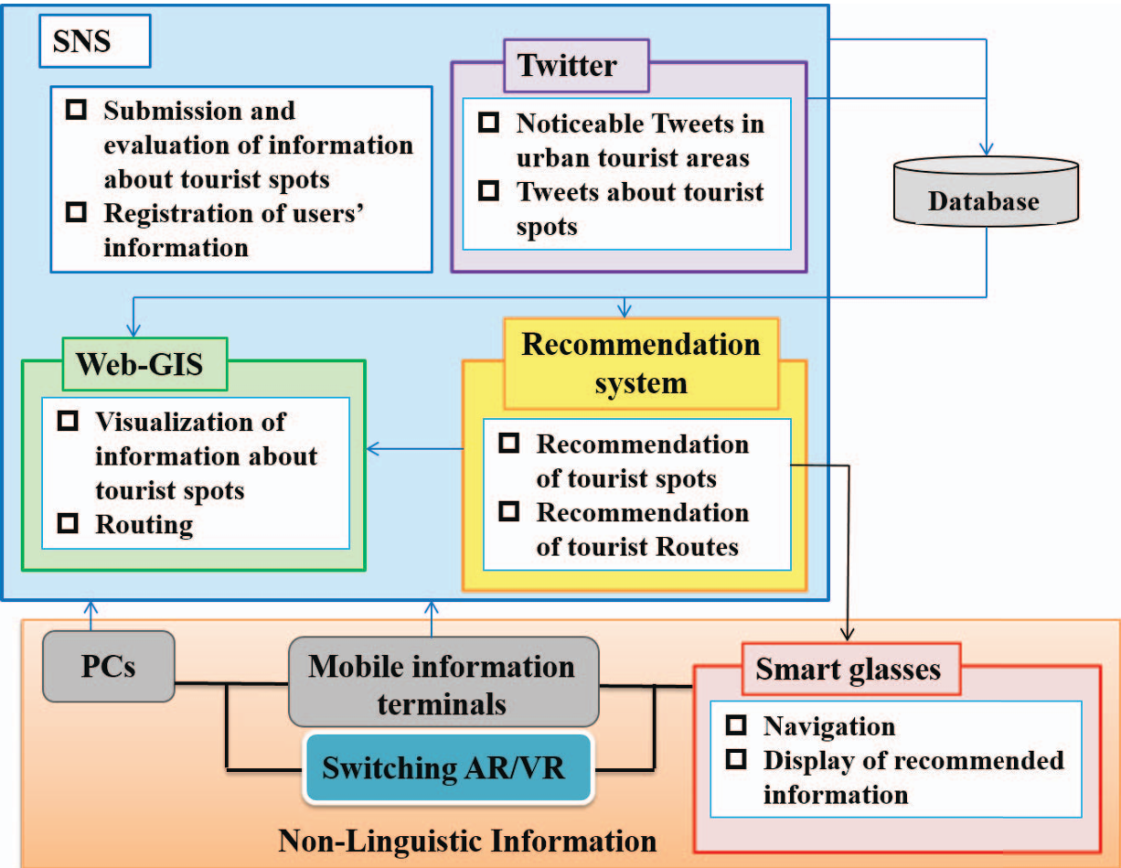 Fig 1: The Integrated System Design featuring GIS, SNS, and AR/VR layers.
3. The Recommendation Engine
The system uses a mathematical approach to similarity. If a user’s preference vector matches another user , the system applies Collaborative Filtering: When user data is sparse, it pivots to Knowledge-Based Recommendations, matching user profiles directly to tourist spot characteristic vectors.
Experimental Results & User Interface
The system was deployed with a focus on the Yokohama center. The interface design demonstrates a clear hierarchy:
- Browser/PC: High-density 2D maps for overview.
- Mobile: 3D VR maps for immersive browsing.
- Smart Glasses: Minimalist AR overlays for safety and efficiency.
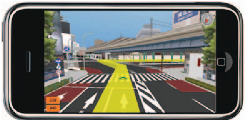 Fig 2: Mobile 3D VR interface (top) and Smart Glass AR perspective (bottom) demonstrating the non-linguistic directional cues.
By integrating Twitter (#yokohamanavi), the system dynamically updates recommendations based on what is currently trending, ensuring that the navigation is not just a map, but a living guide to the city’s pulse.
Critical Analysis: Impact and Limitations
Takeaways
This work proves that non-linguistic cues are a viable "universal language" for navigation. The integration of Twitter provides a "Social GIS" element that makes the system reactive to real-time events—a feature often missing in commercial GPS apps.
Challenges
- Hardware Adoption: Relying on specific smart glasses (like SONY SmartEyeglass) limits immediate mass adoption compared to smartphone-only AR.
- Data Moderation: While the system includes an administrator backend to delete malicious "Tweets" or posts, the scale of real-time social media moderation remains a challenge for long-term deployment.
Future Outlook
The authors plan to transition this from a prototype to a full operation in Kanagawa Prefecture. As AR glasses become lighter and more integrated with AI, the "Pictogram-based" navigation proposed here could become the standard for the inclusive, "smart city" tourism of the future.