
Automated Fiber-Optic Landmark Localization: Scaling DAS with Bilinear ResNets
Automatic Fine-Grained Localization Of Utility Pole Landmarks On Distributed Acoustic Sensing Traces Based On Bilinear Resnets
The paper introduces an automated framework for the fine-grained localization of utility poles in Distributed Acoustic Sensing (DAS) data using Bilinear ResNets. By transforming spatiotemporal vibration signals into image-like tensors, the method achieves human-expert level pinpointing of landmarks, facilitating the mapping of acoustic events to physical geographic coordinates.
TL;DR
Distributed Acoustic Sensing (DAS) turns fiber-optic cables into giant microphones, but knowing exactly where a signal happens in the physical world requires identifying utility poles along the line. This paper introduces an automated pipeline using Bilinear ResNets to localize these poles with meter-scale accuracy, replacing the tedious manual expert analysis previously required.
The Problem: The "Where" of the Vibration
Distributed Acoustic Sensing (DAS) is a revolutionary technology that monitors vibrations over tens of kilometers. However, DAS only measures distance along the fiber from the interrogator. To map a leak or an intrusion to a GPS coordinate, we need "landmarks"—utility poles.
Currently, detecting these poles involves:
- Striking a pole with a hammer.
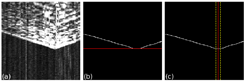
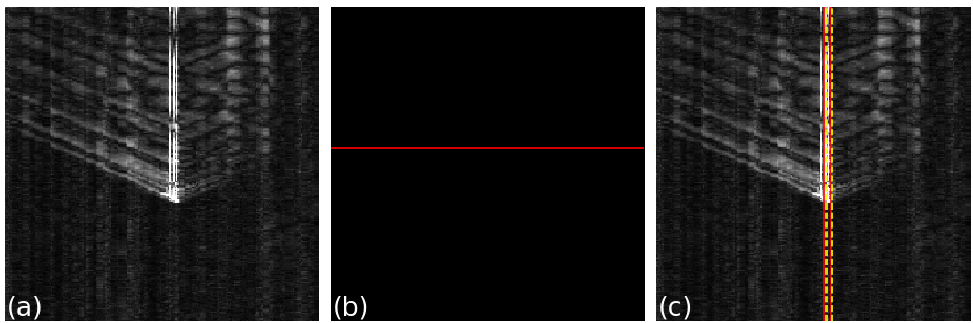
- Manually inspecting the resulting "V-shaped" pattern on a spatiotemporal map.
- Guessing the vertex of that "V" to calculate the fiber distance.
This process is slow, expensive, and subjective. As fiber networks expand to millions of miles, manual labeling becomes the primary bottleneck for industrial adoption.
Methodology: From Edges to Bilinear Features
The authors tackle the "V-shape" vertex detection through two distinct lenses:
1. The Unsupervised Heuristic (Canny Edge Detection)
Since the vertex of the "V" represents the earliest vibration arrival time, one can treat the DAS signal as a grayscale image. By applying Canny Edge Detection, the algorithm identifies the bottom-most pixel of the signal. While intuitive, this method is "brittle"—it fails significantly when the Signal-to-Noise Ratio (SNR) is low.
2. The Bilinear ResNet (BResNet)
To move beyond simple edge detection, the authors employ a supervised Deep Learning approach. They use a ResNet backbone but add a crucial twist: a Bilinear Layer.
- Why Bilinear? Standard CNNs are great at global classification, but landmark localization requires understanding the pairwise interactions of features across space and time. Bilinear pooling allows the model to capture fine-grained patterns in the spatiotemporal matrix, leading to higher precision in pinpointing the vertex.
Experiments & Results
The models were tested on two real-world datasets: Route A and Route B.
Human-Level Accuracy
The BResNet-34 model achieved an Absolute Deviation (ADEV) of approximately 1.0 to 1.4 meters. Given the spatial resolution of the DAS hardware is ~1.22 meters, the model is essentially operating at the hardware's physical limit—matching or exceeding human experts.
Robustness to Noise
A standout finding is the model's resilience. In experiments where the researchers intentionally corrupted training labels (simulating "lazy" or "bad" human annotators), the BResNet maintained high performance. Even with 50% of labels perturbed, the error only increased slightly, proving the model learns the structural physics of the "V-shape" rather than just memorizing noisy points.
SOTA Comparison
As seen in the table below, the Bilinear ResNet with MSE loss outperformed standard ResNets and MAE-based approaches consistently.
| Method | ADEV (Lower is Better) | GIoU (Higher is Better) |
|---|---|---|
| ResNet + Bilinear + MSE | 1.10 | 0.55 |
| ResNet + MSE (Standard) | 1.25 | 0.52 |
Critical Insight: The Future of Infrastructure Sensing
This paper demonstrates that the transition from unsupervised heuristics (like edge detection) to learned representations (Bilinear CNNs) is essential for industrial DAS applications.
However, there is a catch: Generalization. When a model trained on Route A is tested on Route B, there is a performance dip. The authors correctly point out that future work must involve Domain Adaptation to ensure a model trained in a rural environment can work seamlessly in a suburban one without needing a fresh set of expensive labels.
Conclusion
By automating utility pole localization, this research removes the final "human-in-the-loop" barrier for distributed sensing. It transforms DAS from a specialized experimental tool into a deployable, scalable solution for monitoring the world's critical communication infrastructure.