
Intelligent Maritime Surveillance: Bridging the Gap Between Radar Signatures and Environmental Reality
Automatic recognition of coastal and oceanic environmental events with orbital radars
This paper presents an automated classification framework for identifying oceanic environmental events in RADARSAT-1 SAR images. Using a two-stage machine learning approach with Support Vector Machines (SVM), the system successfully differentiates between seven classes of oil spills and meteo-oceanographic phenomena with high accuracy (AUC up to 93%).
TL;DR
Researchers from PETROBRAS and the Federal University of Rio de Janeiro have developed a robust, two-stage automated system to classify oceanic events in SAR images. By utilizing Support Vector Machines (SVM) and a rich set of 40 features, the system distinguishes oil spills from "look-alikes" (like algae blooms) with a 93% AUC, even when critical meteorological data is partially missing.
Background: The "Look-Alike" Challenge in Radar Imagery
Synthetic Aperture Radar (SAR) is the gold standard for oceanic monitoring because it works through clouds and darkness. However, it suffers from a major ambiguity: any phenomenon that dampens capillary waves—be it an oil spill, a rain cell, or a biological film—appears as a "dark patch" (low backscatter).
The core motivation of this study was to move beyond simple "oil vs. clean water" detection. The authors aimed to build a system capable of identifying the source of the patch (e.g., an operational rig spill vs. a ship release) and differentiating it from natural meteo-oceanographic events.
Methodology: A Hierarchical Approach to Classification
The researchers processed 402 RADARSAT-1 images from the Brazilian coast, identifying 779 unique event examples. The workflow followed a rigorous pipeline:
- Segmentation: Individualizing dark patches using multi-resolution algorithms.
- Feature Extraction: Calculating 40 distinct features across six domains: Scene, Spectral, Textural, Geometrical, Meteo-oceanographic (METOC), and Location.
- Two-Stage Classification: Instead of a flat "one-vs-all" classifier, they used a tree-like strategy:
- Stage 1: Is it an Oil Spill or a Meteo-oceanographic phenomenon?
- Stage 2: Specific class identification (e.g., Algae Bloom vs. Rain Cell).
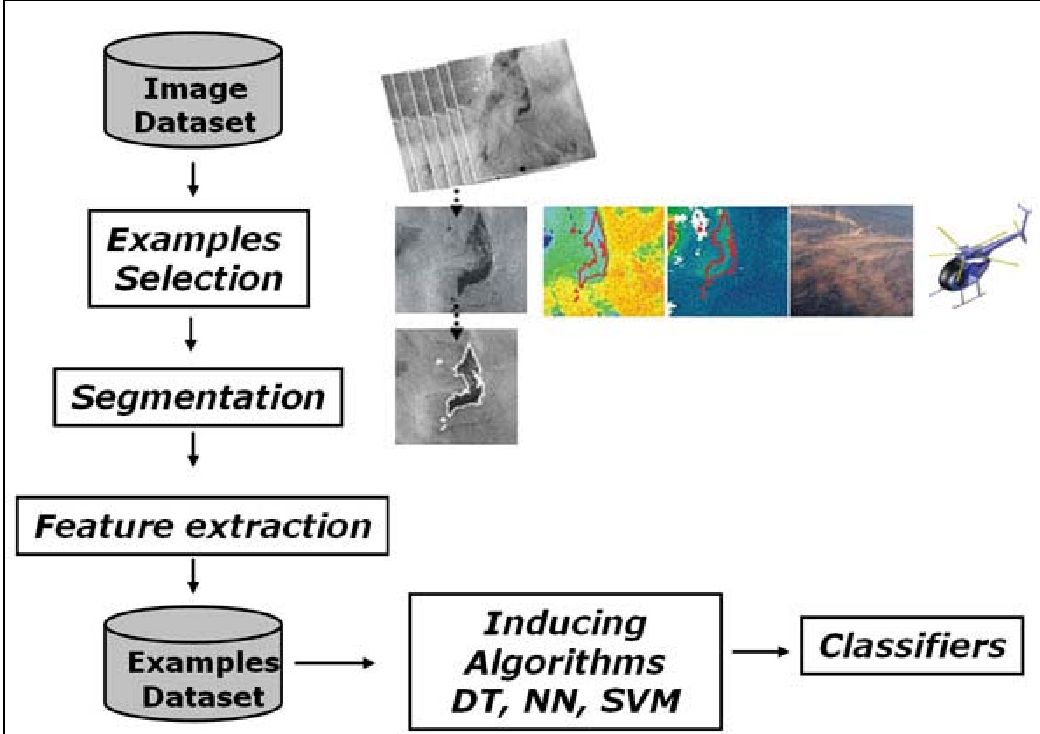 Figure 1: The methodology highlights the fusion of SAR features with ancillary METOC data (Wind, Temperature, Chlorophyll).
Experimental Performance: SVM Takes the Lead
The study compared Decision Trees (DT), Neural Networks (NN), and Support Vector Machines (SVM).
| Question Category | DT (AUC %) | NN (AUC %) | SVM (AUC %) |
|---|---|---|---|
| Q1: Oil vs. Natural | 84 | 90 | 93 |
| Q2: Oil Sub-classes | 84 | 87 | 91 |
| Q3: Natural Sub-classes | 86 | 82 | 93 |
Key Insights from the Results:
- The Power of SVM: With a Radial Basis Function (RBF) kernel, SVM consistently reached 91-93% AUC, proving highly effective for high-dimensional feature spaces.
- The METOC Dependency: Identifying natural events like rain cells or upwellings depends heavily on external data (SST, wind). Removing these features caused the error rate for natural phenomena to nearly double (from 14% to 25%).
- Oil Spill Resilience: Interestingly, oil spill detection remained stable even without METOC data, suggesting that the geometric and spectral "fingerprint" of oil is more distinct than its natural counterparts.
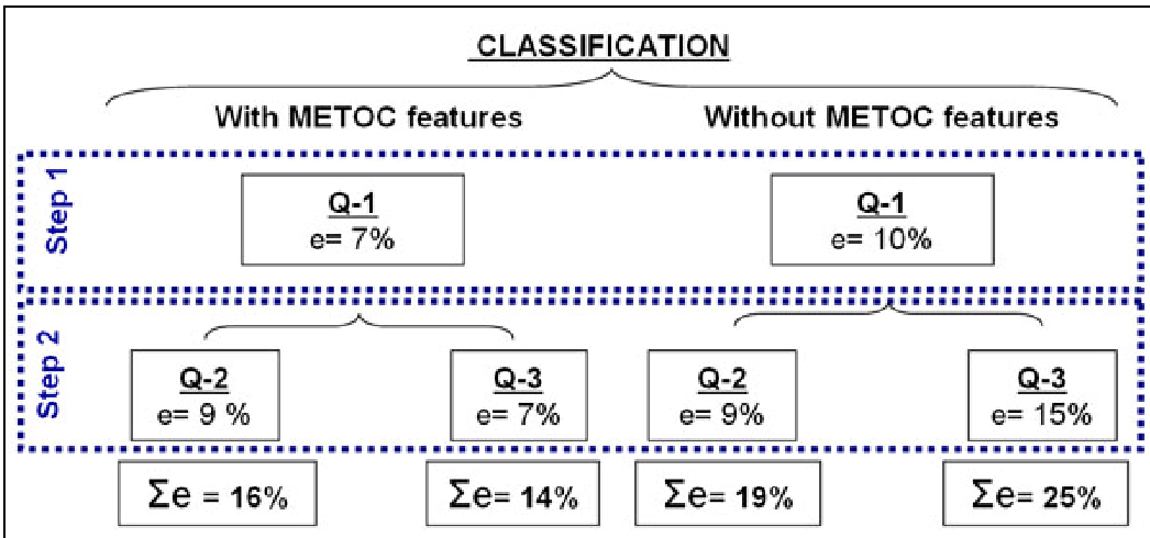 Figure 2: Summary of error rates for the best-performing SVM models.
Critical Analysis & Future Outlook
This work represents a significant step toward operational automation. By creating a system that can run without calibrated radiometric data (using raw pixel values to save time), the authors prioritize the "almost real-time" needs of environmental response teams.
Limitations: Despite the high accuracy, the "patch individualization" (segmentation) phase still requires human supervision. True end-to-end automation would require more advanced computer vision techniques (like Mask R-CNN) to handle complex, overlapping patches.
Future Directions: The integration of new satellite constellations and the use of Ensemble Methods (Bagging/Boosting) represent the next logical evolution. As the dataset grows, moving from classical machine learning to deep learning could further reduce the 16-19% error rate observed in specific sub-class identification.
Takeaway for the Industry: Context is king. To build a reliable oil spill detection system, you cannot rely on radar alone; you must integrate the "biological and physical state" of the ocean to filter out the noise of the natural environment.