
BaroSense: Turning Smartphones into Low-Power Traffic Probes via Barometers
BaroSense: Using Barometer for Road Traffic Congestion Detection and Path Estimation with Crowdsourcing
BaroSense is a mobile crowdsourcing system designed for road traffic congestion detection and path estimation using smartphone barometer sensors. By analyzing altitude variations and utilizing Dynamic Time Warping (DTW), it achieves high-accuracy traffic state classification and identifies specific congested road segments with minimal power consumption.
TL;DR
BaroSense is an innovative framework that uses the barometer sensor in smartphones to detect traffic jams and estimate vehicle paths. By treating road altitude changes as a unique "signature" and using Dynamic Time Warping (DTW) for matching, the system achieves over 97% accuracy in detecting "stuck" traffic states while consuming significantly less power than GPS or accelerometers.
Background & Motivation: Beyond the Power-Hungry GPS
Traffic congestion is a global urban crisis. While apps like Google Maps use GPS to monitor traffic, this approach has two fatal flaws: High Power Consumption and Privacy Concerns. In developing countries where commuters rely on two-wheelers or public transport, keeping GPS on for hours is often impossible due to battery constraints.
The authors of BaroSense identified a physical intuition: Roads are not flat. Even minor inclines create distinct atmospheric pressure changes. Because modern smartphone barometers are highly sensitive and consume less than 10μW (compared to 170mW+ for GPS), they represent the perfect "passive" sensor for continuous traffic monitoring.
Methodology: The Science of "Road Signatures"
1. Activity Recognition (RoadSphygmo)
The system first classifies user state into "Still" or "Motion."
- Jumps: A "jump" is defined as an altitude change of 0.8m to 1.0m within 5 seconds.
- Logic: A moving vehicle encounters frequent altitude variations (many jumps), while a stationary one does not.
- Classifier: An SVM with a Radial Basis Function (RBF) kernel processes a window of 20 seconds to distinguish these states.
2. Path Estimation via DTW
When a "stuck" state is detected, the system must know which road led to the jam.
- The Signature: Every road segment has a unique altitude profile.
- The Matching: Since vehicle speeds vary, the time-series data of a user's journey won't perfectly match the database in length. The authors use Dynamic Time Warping (DTW), a dynamic programming algorithm that aligns sequences of different lengths to find the minimum distance between a user's sensor data and pre-stored road maps.
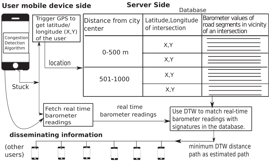
Crowdsourcing & The Power of Correlation
A unique contribution of this work is the use of Correlation. Users in the same vehicle (or same traffic flow) experience near-identical pressure changes.
- Verification: If two users show a correlation coefficient of 0.99, they are likely in the same bus.
- Majority Voting: By aggregating data from multiple phones at a single intersection, the system filters out noise (e.g., an individual opening a car window or turning on AC), bringing the "Stuck" detection accuracy to near-perfection.
Experimental Results: Real-World Validation
The authors tested the system in Chandigarh and Mumbai using various phones (Nexus 5, Xiaomi Mi4, etc.).
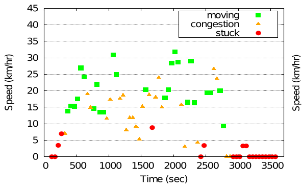
- Stuck State: Achieved up to 100% accuracy on some devices (averaging 97.36% across the board).
- Path Estimation: Successfully identified 72 out of 80 road segments correctly (90% accuracy).
- Robustness: The system remained stable even when phones were in pockets, bags, or in environments with AC transitions.
Critical Insight & Outlook
BaroSense shifts the paradigm of traffic sensing from "tracking coordinates" to "sensing environment."
Limitations: The system relies on a pre-built database of road altitude signatures. While Google Elevation API provides a starting point, high-resolution mapping of every urban alleyway remains a challenge for scalability.
Future Impact: This work opens doors for "Zero-Energy" urban sensing. Beyond traffic, the correlation method can be used for automated bus occupancy counting and detecting "boarding/deboarding" events—essential for the next generation of Smart City infrastructure.
Conclusion
By looking at the barometer—a sensor usually reserved for weather apps—BaroSense proves that clever algorithmic matching can turn "noise" into high-fidelity traffic intelligence without killing your battery or infringing on granular location privacy.