
BaroSense: Turning Smartphones into Urban Pulse Monitors via Barometers
BaroSense: Using Barometer for Road Traffic Congestion Detection and Path Estimation with Crowdsourcing
BaroSense is a low-power system for road traffic congestion detection and path estimation using smartphone barometer sensors. It employs the "RoadSphygmo" algorithm to classify traffic states and utilizes Dynamic Time Warping (DTW) to match pressure signatures with a road database, achieving high accuracy in "stuck" state detection and path recovery.
TL;DR
BaroSense is an innovative system that repurposes the humble barometer sensor—typically used for floor detection or weather—to monitor city-wide traffic congestion. By treating road-level altitude variations as "signatures," it detects traffic jams with 97% accuracy and estimates the path leading to the jam, all while consuming a fraction of the power required by GPS.
Context: The Power Hungry Nature of Traffic Sensing
In the world of Intelligent Transportation Systems (ITS), we face a paradox: to get real-time traffic data, we need crowdsourcing; however, the most common crowdsourcing tool, GPS, is a battery killer. In developing nations or for commuters on public transport, keeping GPS active for a 3-hour journey is often impossible.
The authors of BaroSense identified a "free" data source: Road Geometry. No road is perfectly flat. Every segment has a unique altitude profile. Since barometers are sensitive enough to detect sub-meter changes in elevation and are incredibly low-power (consuming ~1.7μA), they serve as the perfect passive monitors.
Methodology: From Pressure to Path
The system operates on two tiers:
1. RoadSphygmo: The Congestion Detector
The system first classifies movement into "Still" or "Motion." It calculates "jumps" (altitude changes of >0.8m over 5 seconds).
- Still: Low/zero jumps.
- Motion: Frequent jumps as the car traverses road undulations.
Using a Support Vector Machine (SVM) with an RBF kernel, it processes 20-second windows. If enough "Still" periods accumulate in a 2-minute window, the traffic state is flagged as "Stuck."
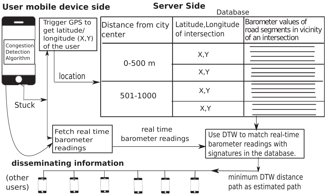 Figure: The BaroSense Architecture - from Client activity recognition to Server-side path estimation.
2. Path Estimation via DTW
When a "Stuck" state is detected, the server needs to know which road led to the jam. It uses Dynamic Time Warping (DTW).
- The Challenge: Two drivers on the same road might drive at different speeds, creating sequences of different lengths.
- The Solution: DTW aligns these sequences by warping the time axis, find the "lowest cost" match between the real-time query and pre-recorded road signatures.
Experimental Results & Crowdsourcing Power
The authors tested the system across multiple cities (Chandigarh, Mumbai) and various devices (Nexus 5, Xiaomi Mi4).
- Detection Accuracy: The "Stuck" state is nearly perfectly identified (97%+). "Moving" and "Congestion" states are harder to distinguish due to stop-and-go traffic, but still perform well.
- Database Scalability: The system is efficient. It takes only 0.21 seconds to perform 40 DTW street matchings on a standard i5 processor.
- The Crowdsourcing Multiplier: By correlating data from multiple users near the same location, the system uses Majority Voting to filter out noise, significantly boosting accuracy over individual devices.
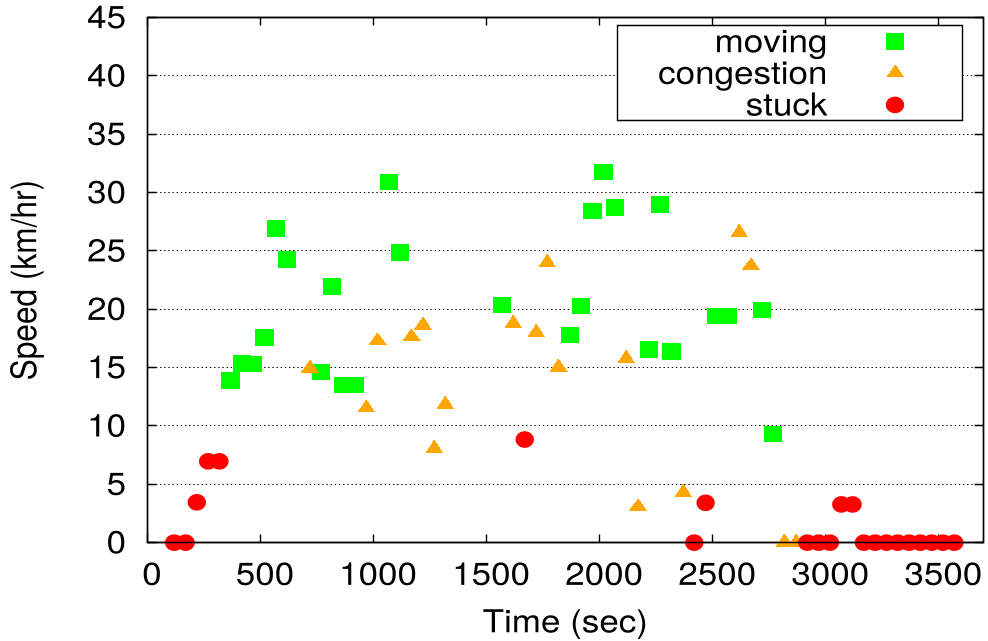 Figure: The impact of Majority Voting on state classification, effectively smoothing out individual sensor noise.
Deep Insight: Beyond Just Traffic
One of the most profound contributions is the use of Barometric Correlation. The authors discovered that two phones in the same vehicle share a correlation of ~0.99. This allows for:
- Bus Occupancy Estimation: Counting correlated phones to estimate how crowded a bus is.
- Boarding/Deboarding Detection: Recognizing the exact moment a user joins a vehicle's altitude "stream."
Critical Analysis & Future Outlook
Limitations: The system relies on road altitude variations. In a perfectly flat city (if one exists), the "signature" might be too weak. Additionally, environmental pressure changes (weather) are handled by using relative altitude, but extreme storms might still introduce noise.
Conclusion: BaroSense proves that we don't always need "expensive" data like GPS. By cleverly using high-resolution, low-power environmental sensors, we can build a privacy-preserving (users aren't tracked continuously), energy-efficient urban monitoring system that works where infrastructure fails.