
Beidou-Powered Autonomy: Redefining Agricultural Precision with Motor-Type Steering
Design and Experimental Study on Motor Type Automatic Driving System of Agricultural Machinery Based on Beidou Navigation
This paper presents a motor-type automatic driving system for agricultural machinery based on the Beidou Navigation Satellite System. The authors developed an innovative coaxial angular displacement device and a multi-sensor fusion navigation method (GNSS/INS/Vehicle) to achieve centimeter-level field operation accuracy.
TL;DR
Researchers have developed a motor-type automatic driving system for tractors that leverages the Beidou Navigation Satellite System and a GNSS/INS/Vehicle fusion method. The system achieves centimeter-level straightness accuracy (approx. 1.6 - 1.9 cm) without the need for invasive hydraulic modifications, offering a highly adaptable solution for modernizing diverse agricultural machinery.
Background and Motivation
The transition to Precision Agriculture (PA) hinges on the ability of machinery to follow predetermined paths with minimal error. While hydraulic systems have been the SOTA for years due to their stability, they suffer from high refitting costs and poor cross-machine compatibility.
The authors identify two core challenges:
- Hardware Matching: How to automate steering without tearing apart the vehicle's existing steering system.
- Signal Robustness: How to maintain accuracy when satellite signals are blocked by foliage or terrain.
Methodology: The Fusion of Mechanical Simplicity and Algorithmic Complexity
1. Motor-Type Control Strategy
Unlike hydraulic bypasses, this system uses an electrically controlled steering wheel. This "add-on" approach allows the tractor to retain its manual steering capability while enabling automated path-following. The control loop relies on a real-time comparison between the vehicle's current attitude and the target path, adjusting the motor output to minimize lateral deviation.
2. GNSS/INS/Vehicle Integrated Navigation
A standout feature of this research is the navigation method. By combining GNSS (Global Navigation Satellite System), INS (Inertial Navigation System), and vehicle speed data, the system creates a redundant positioning framework.
- The Intuition: When the GNSS signal drops out, the INS provides short-term dead reckoning. By adding "vehicle" data (odometry/kinematics), the system can better suppress the inherent drift (divergence) of the Inertial Measurement Unit (IMU).
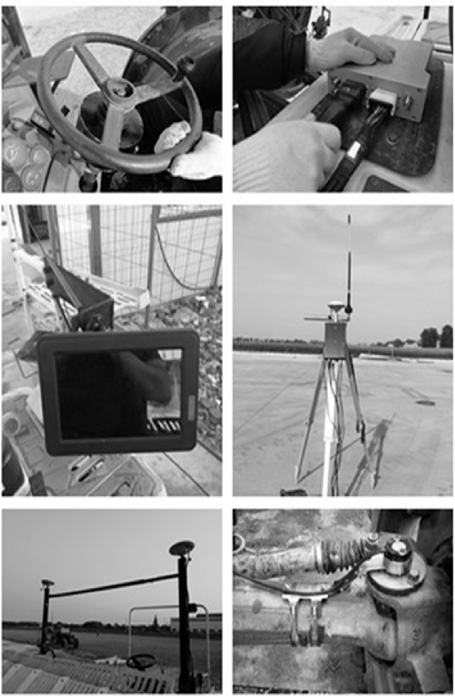 Figure 1: The operational workflow of the Beidou-based autopilot system.
3. Innovative Angle Measurement
The team designed a coaxial angular displacement device utilizing a Hall sensor and magnetic blocks. This simple yet effective mechanical design converts the wheel's rotation into a voltage signal, providing high-precision feedback to the control unit regarding the actual steering angle.
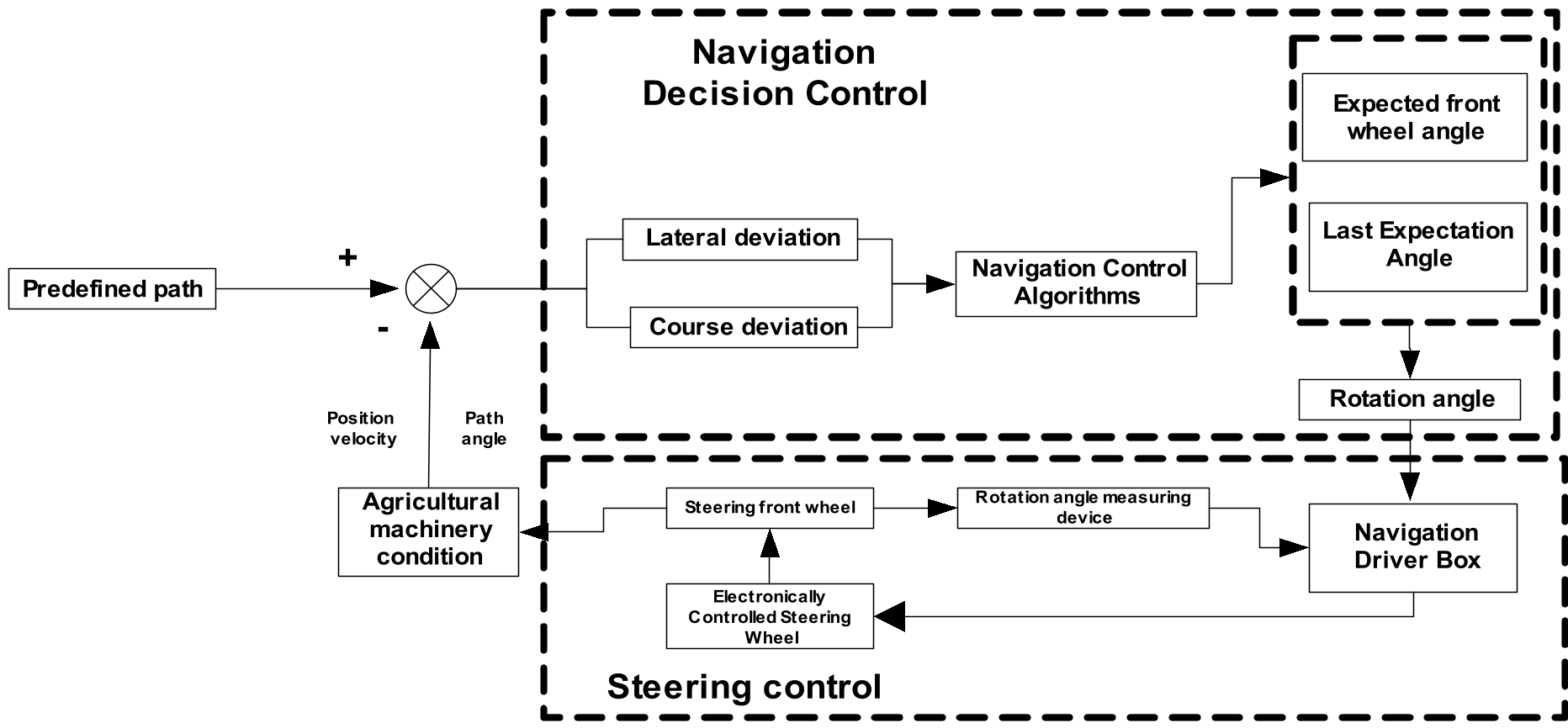 Figure 2: System control strategy for path correction.
Experiments and Performance
The system was tested using a tractor equipped with a third-party high-precision RTK satellite receiver to serve as the ground truth.
Key Metrics:
- Straightness Accuracy (): Measures how well the tractor stays on the A-B line.
- Spacing Accuracy (): Measures the consistency of the distance between adjacent passes (connecting lines).
| Speed | Straightness Accuracy () | Spacing Accuracy () |
|---|---|---|
| 0.5 m/s | 1.678 cm | 2.428 cm |
| 2.5 m/s | 1.965 cm | 2.525 cm |
The results indicate that even at higher speeds (2.5 m/s), the deviation remains under 2 cm for straight paths. The slight increase in connecting line spacing error at higher speeds was attributed by the authors to manual turning inconsistencies and limited monitoring sites during lane changes.
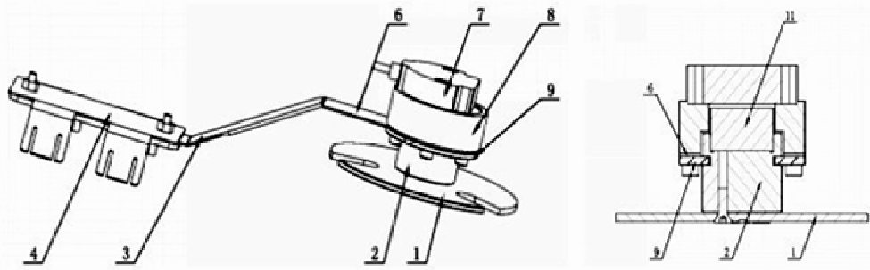 Figure 3: Third-party high precision receiver used for performance validation.
Critical Analysis & Conclusion
This work demonstrates that motor-type drivers are no longer "second-tier" options compared to hydraulic systems. By focusing on sensor fusion (GNSS/INS/Vehicle) and refined mechanical feedback (Hall-effect sensors), the authors achieved accuracy levels required for the most demanding agricultural tasks like seeding and ridge-forming.
Limitations: The study highlights that spacing accuracy slightly exceeds the 2.5cm target at higher speeds. This suggests that the manual-to-auto transition during headland turns remains a bottleneck. Future work should likely focus on automated headland turning (U-turn) algorithms to eliminate human error entirely.
Final Takeaway: This system provides a blueprint for low-cost, high-precision agricultural upgrades, effectively breaking the platform-specific monopoly of traditional GNSS steering providers.