
AccessMap: Scaling Digital Inclusivity through Smartphone-based Crowdsourcing
Better off This Way!: Ubiquitous Accessibility Digital Maps via Smartphone-based Crowdsourcing
AccessMap is an automated, smartphone-based crowdsourcing system designed to augment digital maps with accessibility semantics (e.g., ramps, elevators, and audible signals). By leveraging a probabilistic framework and multi-modal sensor fusion (accelerometer, barometer, and microphone), it achieves high-fidelity mapping for both indoor and outdoor environments, reaching 98.7% precision and 99% recall with minimal user encounters.
TL;DR
AccessMap is a system that automatically creates rich accessibility maps by "listening" and "feeling" the environment through standard smartphone sensors. By crowdsourcing data from everyday users, it identifies ramps, elevators, and audible signals with near-perfect accuracy (99% recall) after just seven encounters, working seamlessly both indoors and outdoors where satellite-based mapping fails.
Context: The Invisible Barriers in Digital Maps
While modern navigation systems are excellent at guiding cars through highways, they are "blind" to the micro-level obstacles that dictate life for people with disabilities. A single missing curb ramp or an unannounced elevator floor can render a route impassable for a wheelchair user or a visually impaired pedestrian.
The core challenge is scalability. We cannot manually survey every inch of a city. Previous attempts used Computer Vision on Google Street View, but these methods are limited by "visual-only" data and cannot penetrate indoor spaces like metro stations or malls.
Methodology: Fusing Physical Intuition with Machine Learning
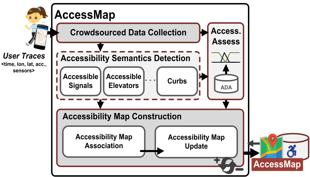
The genius of AccessMap lies in how it translates physical movement into semantic data. Instead of relying only on images, it uses the smartphone as a high-fidelity probe of the environment's geometry and acoustics.
1. Multi-Modal Sensing Logic
The system categorizes sensors into "Low-cost" (always on) and "Sensitive" (gated).
- Vertical Transitions (Elevators & Ramps): The barometer detects air pressure changes. A rapid spike in pressure slope indicates an elevator. A shallow, consistent change indicates a ramp.
- Physical Obstacles (Staircases & Curbs): The accelerometer captures the distinct "jolt" of stepping up a curb versus the rhythmic high-variance peaks of climbing stairs.
- Audio Cues: To identify "Accessible Pedestrian Signals," the system performs FFT (Fast Fourier Transform) on recorded audio to find the dominant 880 Hz tone mandated by accessibility standards.
2. The Probabilistic Map Framework
No single sensor reading is perfect. AccessMap treats every detection as a "candidate" semantic. It uses a Bayesian Update rule to increase confidence in a landmark as more users encounter it. For localization, it utilizes a Kalman Filter to fuse noisy GPS/WiFi tags into a precise coordinate, effectively "narrowing down" the exact location of a ramp or signal over time.
Experiments and Results: The Power of the Crowd
The researchers tested the system across the USA and Egypt, covering 42km of traces.
- High-Fidelity Detection: Individual detectors for stairs, elevators, and signals achieved an average F-score above 88%. Ramps were the hardest to detect due to their design (meant to feel like flat ground), but the fusion of barometer and accelerometer significantly improved performance.
- Crowdsourcing Gain: The most striking result is the "law of large numbers" in mapping. While a single pass might have noise, by the 7th encounter, the map's precision climbs to 98.7%.
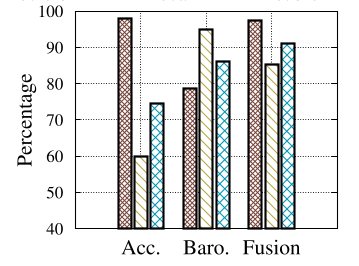 Figure: The precision and recall improvements as encounter counts increase.
Critical Insight & Outlook
AccessMap succeeds because it treats accessibility mapping as a Signal Processing problem rather than just a Computer Vision problem. By focusing on the interaction between the user and the space (the vibration of a step, the pressure of an elevator), it captures semantics that are invisible to satellites.
Limitations & Future Work: Currently, the system requires a high volume of users to refine the map. In sparsely populated areas, the initial "confidence" (alpha) remains low. Future iterations could integrate Federated Learning to improve the core detection models without compromising user privacy, making the "passive" nature of the system even more robust.
AccessMap proves that the tools for a more inclusive world are already in our pockets; we just need the right algorithms to listen to what they are telling us.