
BScanner: Decoding Urban Accessibility Through Diversified Crowdsourcing
BScanner: A Crowdsourcing Platform for Constructing Accessibility Maps to Support Multiple Participation Types
BScanner is a heterogeneous crowdsourcing platform designed to construct urban accessibility maps by integrating deep learning-based sensor analysis, gamification, and manual reporting. It achieves a high classification F-measure of 0.89 for detecting road barriers such as stairs and slopes using smartphone IMU data.
TL;DR
BScanner is a multi-modal crowdsourcing framework designed to map urban accessibility barriers (like stairs and steep slopes). Unlike previous apps that require active volunteering, BScanner offers three ways to help: manual reporting, passive background sensing while walking, or playing a location-based territory game. By leveraging deep learning on smartphone sensor data, it achieves a high accuracy (0.89 F-measure) in identifying road obstacles.
Positioning: This work is a functional integration of HCI (Human-Computer Interaction) and Machine Learning, focusing on the sustainability of crowdsourced data collection for social good.
Problem & Motivation: The Gap in Urban Mobility
For the elderly or people with impairments, a single step can be an insurmountable barrier. However, creating a comprehensive "Accessibility Map" is a logistical nightmare.
- Vision-based attempts (using Google Street View) are limited by image resolution and frequent "occlusions" (cars or trees blocking the view of the curb).
- Existing Crowdsourcing often fails because it demands too much from the user. If you aren't a highly dedicated volunteer with hours of free time, you likely won't contribute.
The authors' insight was simple: If we want better coverage, we must adapt the task to the user’s life, not the other way around.
Methodology: The Three Pillars of Participation
The core innovation of BScanner is its support for multiple "Participation Types," classified by Motivation and Time:
- Manual Reporting: For the "Power Users." Users take photos and tag barriers. (High Accuracy, Low Coverage).
- Walking: For the "Busy Proponents." Users simply turn the app on while commuting. The phone stays in the pocket, and deep learning does the rest. (High Coverage, Passive).
- Game Playing: For the "Casual Users." A "Pokémon GO" style territory game where walking through unmapped areas expands your team's (Red vs. Blue) zone. (High Engagement).
The Deep Learning Engine
To make passive "Walking" and "Gaming" useful, BScanner uses a Neural Network to interpret the "shaking" of the phone.
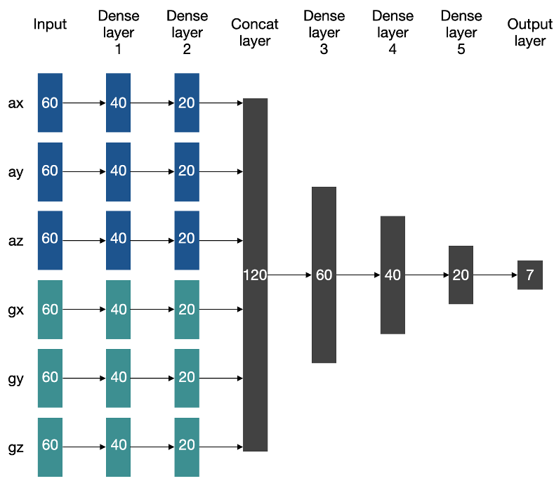
The model acts on 3-second windows of 20Hz IMU data (Acceleration + Gyroscope) to classify the terrain into 7 types: Flat, Up/Down Step, Up/Down Stairs, and High Slopes.
Experiments & Results: Mapping Reality
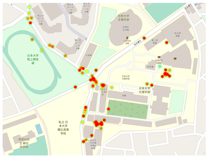
The system doesn't just collect points; it creates a "probability surface."
- Performance: The neural network achieves an F-measure of 0.89, proving that pocket-based sensing is reliable for identifying major architectural barriers.
- Visualization: instead of cluttered icons, BScanner uses Heatmaps. Red zones indicate a high probability of barriers based on the aggregate sensor data from many walkers.
Critical Analysis & Conclusion
Takeaway
BScanner proves that crowdsourcing for accessibility doesn't have to be a "charity" task. By embedding sensing into daily routines and games, we can achieve the coverage needed for truly useful maps.
Limitations
- Placement Dependency: The current model assumes the phone is in a trouser pocket. If it's in a backpack or a hand, the "signal signature" changes drastically.
- Target Exclusion: Currently, the data is collected by able-bodied walkers. While this provides great coverage, it might miss the specific nuances of a wheelchair user's experience (e.g., surface roughness).
Future Work
The next step for BScanner involves integrating these three separate apps into a single unified experience and using "Domain Adaptation" to allow sensing from any pocket or bag.
This blog post summarizes "BScanner: A Crowdsourcing Platform for Constructing Accessibility Maps to Support Multiple Participation Types" - OzCHI '20.