
Camel: Mining Collective Travel Routes from Sparse Instagram Trajectories
Camel: A Journey Group T-Pattern Mining System Based on Instagram Trajectory Data
This paper introduces Camel, a trajectory mining system designed to identify Journey Group T-Patterns (JG T-Patterns) from sparse User-Generated Content (UGC), specifically Instagram photo metadata. Unlike traditional GPS-based systems, Camel utilizes a density-based clustering strategy and a linkable cluster mechanism to uncover popular travel routes despite irregular and sparse temporal data.
TL;DR
Camel is a specialized mining system designed to uncover Journey Group T-Patterns (JG T-Patterns)—popular travel routes shared by many users—from sparse, irregular Instagram data. By moving away from time-rigid GPS snapshots and utilizing a density-based linkable cluster approach, Camel identifies "hot routes" even when users deviate from the path or post infrequently.
Context: Why Dense GPS Methods Fail on Social Media
Most trajectory mining research (e.g., Swarm, Flock, or Gathering) originated in the world of GPS sensors. These sensors provide dense data: regular, automatic pings that allow researchers to take "snapshots" of where everyone is at a specific second.
However, social media data like Instagram is UGC-based (User Generated Content) and naturally sparse. Users only "ping" the system when they post a photo. The time gap between points is irregular—sometimes hours, sometimes days. Traditional snapshot-based algorithms fail here because the probability of two users having a data point at the exact same timestamp is near zero.
Methodology: The Journey Group Concept
To solve the sparsity problem, the authors introduce the JG T-Pattern. This concept derives from "Swarm" but relaxes the temporal constraints. Instead of looking for users moving together in real-time, it looks for users following the same spatial sequence.
1. Spatial Hashing & Clustering
The map is divided into a grid. Points are stored in a hash table where the key is the grid index and the value is a list of trajectory points. Camel then performs density-based clustering within these grids to identify "hotspots."
2. The Linking Logic
A "Journey Group" is formed by linking these clusters (). The criteria are:
- Participation: A minimum number of users () must be in a cluster.
- Continuity: At least common users must move from one cluster to the next.
- Departure Tolerance: Users are allowed to "depart" (post elsewhere) and return to the main trajectory a set number of times.
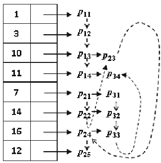 Figure 1: Visualizing how individual trajectories (P1, P2, P3) are clustered and linked to form a JG T-Pattern.
System Demonstration & Results
The authors built the Camel prototype using the Google Map API. They tested the system on photo data from five major Australian cities (Sydney, Melbourne, Brisbane, Perth, and Darwin).
Key Findings:
- User Trajectories: The system successfully mapped 2,000+ user paths simultaneously.
- Pattern Discovery: By setting parameters like (clustering radius) and (min users), the system identified distinct red directional lines representing the most "famous" routes.
- Insight: One significant pattern discovered was the high frequency of Australian domestic travelers also appearing in locations within the United States, showcasing the system's ability to track long-distance, large-scale travel behaviors.
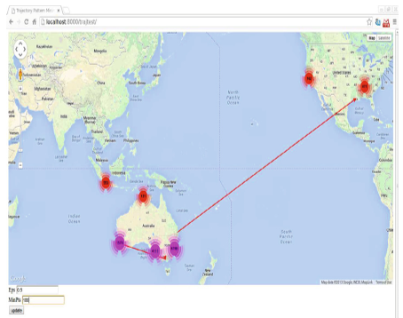 Figure 2: The Camel interface showing mined clusters (circles) and the resulting JG T-Patterns (red arrows).
Critical Analysis & Future Outlook
Camel effectively bridges the gap between traditional trajectory mining and the "Small Data" problem inherent in social media. Its strength lies in its Inductive Bias: it assumes that the sequence of locations is more important than the exact time of arrival.
Limitations: Currently, the system uses a fixed grid size for the hash table. In future work, adopting Adaptive Grid sizes or Hierarchical Clustering (like HDBSCAN) could help in identifying hotspots of varying geographic scales (e.g., a single landmark vs. an entire city district). Additionally, incorporating the content of the Instagram posts (using Computer Vision) could further refine the "type" of Journey Group being discovered—distinguishing between "nature lovers" and "city explorers."
Conclusion
The Camel system proves that even with sparse, "messy" data from Instagram, we can extract high-value movements. This has massive implications for travel agencies, urban planners, and targeted marketing by revealing the actual "flow" of people through the world's most popular destinations.