
CLAR: Bridging the Semantic Gap Between GPS Coordinates and Human Activities
19147_Collaborative location and activity recommendations with GPS history data.
The paper presents a Collaborative Location and Activity Recommendation (CLAR) system that utilizes GPS trajectory data and sparse user comments to suggest interesting locations based on activity queries and vice-versa. It employs a Collective Matrix Factorization (CMF) approach to integrate GPS histories with external knowledge like POI features and Web-mined activity correlations.
TL;DR
Researchers have developed a system called CLAR that answers two fundamental questions: "Where should I go to eat/sightsee?" and "What else can I do at this specific monument?" By using Collective Matrix Factorization, the system merges sparse GPS logs with POI databases and Web-mined activity correlations, dramatically improving the accuracy of location and activity recommendations.
Context: Beyond Points on a Map
Since 2010, the explosion of GPS-enabled devices has provided us with massive amounts of coordinates. However, a coordinate like (39.99, 116.39) is just a dot. To a human, it’s the "Bird’s Nest" in Beijing—a place for sightseeing, exercise, or dining.
The problem is Data Sparsity. While we have millions of GPS points, we have very few "comments" (labels) telling us why a user stayed there. In the dataset used for this paper, only 530 comments existed for 12,765 trajectories. How do you recommend activities when 99.4% of your matrix is empty?
Methodology: The Power of Shared Latent Spaces
The core innovation of this paper is the move from simple Collaborative Filtering to Collective Matrix Factorization (CMF).
1. Data Modeling
The authors don't just look at GPS dots; they cluster them into Stay Regions (300m x 300m grids) to capture meaningful stops. They then build three distinct matrices:
- Location-Activity (X): The target matrix (very sparse).
- Location-Feature (Y): Built by counting POIs (Point of Interests) like theaters and parks around a stay region, weighted by TF-IDF.
- Activity-Activity (Z): Built by querying search engines (like Bing) for activity pairs (e.g., "Food" + "Shopping") to find common-sense correlations.
2. The Collective Optimization
Instead of analyzing these separately, the CLAR model factorizes all three matrices simultaneously.

By forcing the matrices to share low-rank factors ( for locations and for activities), the model "filters" knowledge from the dense POI data and Web correlations into the empty gaps of the GPS history. If the Web says "People who sightsee often eat nearby," and the POI data says "This grid has a park and 10 restaurants," the model can confidently recommend food at that location even if no GPS user ever commented on it.
Experimental Victory
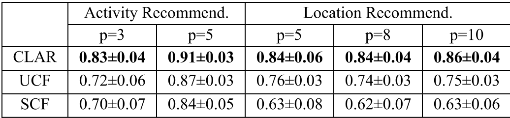
The authors tested CLAR against two strong baselines:
- SCF (Single CF): Uses only the sparse GPS data.
- UCF (Unifying CF): A similarity-fusion approach.
Key Findings:
- Context Matters: Adding location features and activity correlations improved location recommendations by over 20%.
- Efficiency: Despite the complex math, the training time remains linear with respect to the number of stay points, making it scalable to large cities.
Critical Insight: Why Does It Work?
The beauty of this research lies in its Bi-directional Information Flow. In traditional systems, information moves one way: you calculate similarity, then you recommend. In CLAR, the matrix factorization is an iterative loop. The ratings in the GPS data help refine what "features" of a location are actually important, while the POI features help predict the missing ratings.
Conclusion and Limitations
CLAR represents a significant step in making GPS data "semantically aware." However, it is a General Recommender. It tells you what most people do. The next frontier, as noted by the authors, is Personalization: incorporating individual user preferences and social networks into the factorization process to move from "Where should one go?" to "Where should you go?"
Note: This research was a collaboration between Microsoft Research Asia and HKUST, utilizing the GeoLife dataset.