
CommuniSense: Digitizing the Potholes of Nairobi via Mobile Crowdsourcing
CommuniSense: Crowdsourcing Road Hazards in Nairobi
This paper introduces CommuniSense, a mobile crowdsourcing system designed to document and verify road hazards (specifically potholes and speed bumps) in Nairobi, Kenya. It combines an Android-based data collection app with an online crowdsourced verification layer via Amazon Mechanical Turk to ensure high data quality in the absence of traditional monitoring infrastructure.
TL;DR
Nairobi's rapid growth has left its road infrastructure in a state of "dismal" repair, costing the economy billions. CommuniSense is a research-led initiative that leverages the 78% mobile penetration in Kenya to crowdsource road hazard data. By combining a purpose-built Android app with a remote verification layer via Amazon Mechanical Turk, the system transforms citizen frustration into actionable, high-quality spatial data.
Problem & Motivation: The Infrastructure Blind Spot
In rapidly developing metropolises like Nairobi, official infrastructure monitoring is often non-existent or relies on outdated paper-based systems. A resident reporting a pothole might wait 3-6 months for an engineer to even assess the site.
The authors' insights were twofold:
- Sensing is expensive, but phones are everywhere: Installing professional road scanners is too costly for the Kenyan government, but low-cost Android devices are surging in the market.
- Verification is a bottleneck: While anyone can take a photo of a hole in the road, ensuring that the data is not "spam" or mislabeled is hard.
Prior work (like Pothole Patrol) focused on automatic detection using accelerometers. However, these systems need enormous amounts of "labeled ground truth" to be accurate. CommuniSense shifts the focus: why not let the citizens provide the labels directly?
Methodology: Human-in-the-Loop Sensing
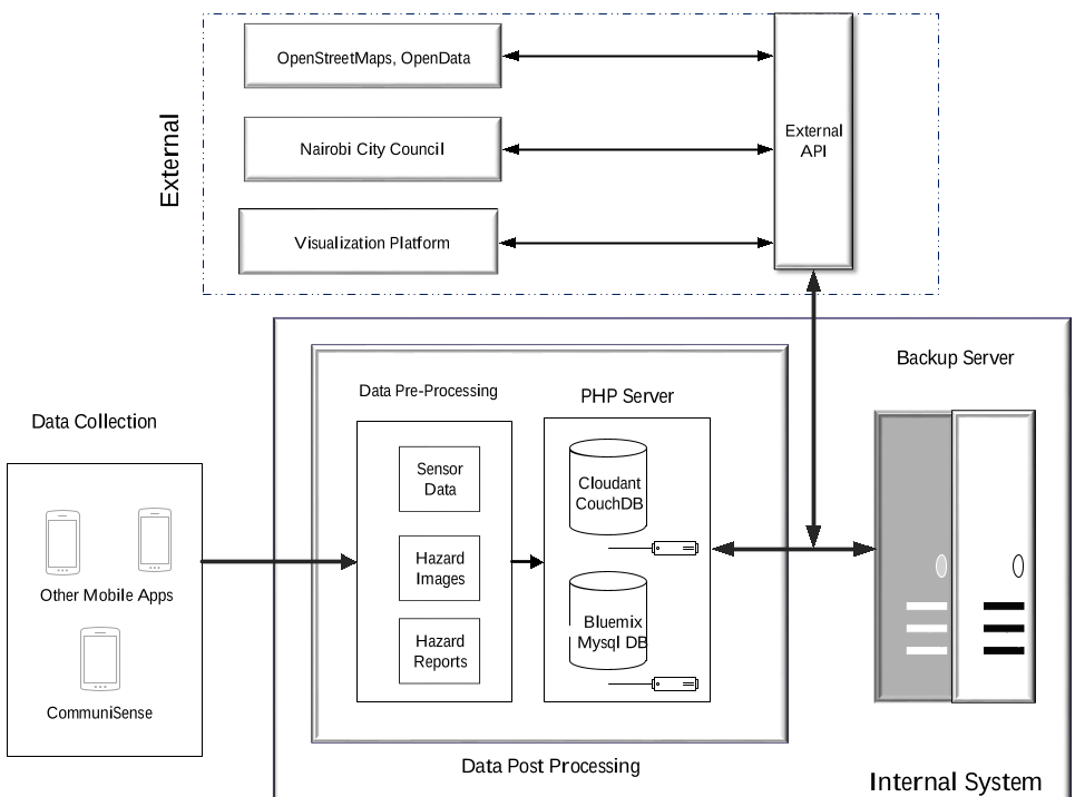
The CommuniSense system consists of three distinct modules:
- The Mobile Client: Users can either submit a "Full Report" (photo + GPS + severity rating) or a "MapIt" report (a simple tap on a map for users in transit).
- The Cloud Backend: A PHP/MySQL stack that handles image compression (Base64) to minimize data costs—a critical factor in regions where 1MB via SMS can cost 3600x more than GPRS.
- The Crowdsourced Verifier: This is the unique technical "twist." The authors used remote workers (MTurk) to verify the images. The workers were asked to classify the hazard and rate its severity, providing an independent check on the mobile users' data.
 The CommuniSense interface: (a) Detailed hazard reporting with imagery and GPS; (b) "MapIt" for quick geo-tagging.
Experiments & Results: 92% Accuracy
The field study in Nairobi proved that even with financial incentives as low as $5.50 for top contributors, users were highly motivated to clean up their streets.
Key Findings:
- High Fidelity: 92% of the mobile submissions were confirmed by the MTurk "Master" workers as being legitimate hazards.
- Inter-Rater Consensus: Using the Intraclass Correlation (ICC) metric, the agreement on "Pothole Severity" was an impressive 0.91, indicating that the crowd can categorize physical road damage with high professional consistency.
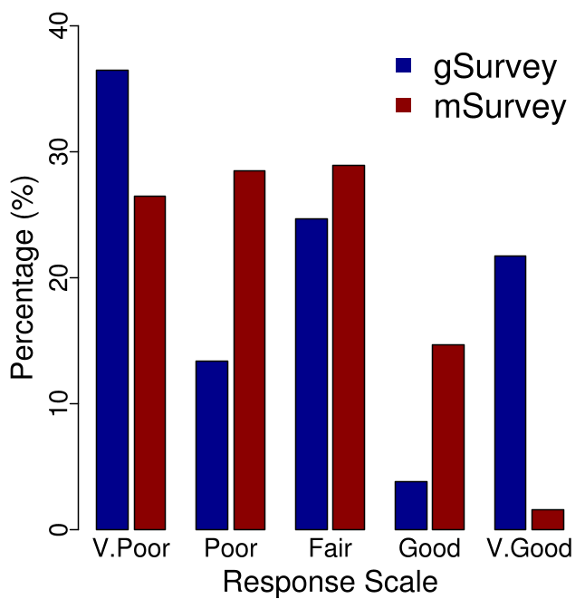
- Diverse Hazards: The system successfully mapped not just potholes, but also unregulated and unlabeled speed bumps, which were surprisingly identified as a major nuisance in the initial citizen survey.
 The spatial distribution of reports across Nairobi, showing broad coverage across various neighborhoods during the pilot.
Critical Analysis & Future Outlook
While CommuniSense is a significant step toward "Smart Cities" in the developing world, the authors noted several hurdles:
- Device Fragmentation: Low-cost "grey market" Android phones often have poor GPS chips, requiring the UI to allow manual "drag-and-drop" correction of coordinates.
- Data Costs: Image submission is expensive. Future iterations might need even more aggressive compression or "Zero-rating" agreements with local telcos.
Conclusion: CommuniSense isn't just an app; it’s a model for "Frugal Innovation." It demonstrates that in the absence of high-tech sensors, the combination of local mobile crowdsourcing and global online verification can provide a robust, transparent, and scalable map of a city's physical health.
Takeaway for the Industry: For AI companies building Smart City models, this research suggests that the most reliable "training data" for road maintenance robots may come from the very citizens who walk these roads every day.