
WiFi-RITA: Reconstructing Indoor Maps from the Chaos of Crowdsourced Traces
Crowdsensing Indoor Walking Paths with Massive Noisy Crowdsourcing User Traces
The paper introduces WiFi-RITA, a robust indoor walking path crowdsensing system designed to reconstruct floor plans from noisy, massive crowdsourced PDR traces. By formulating trace merging as a physical rigid-body optimization problem using WiFi Access Points (APs) as markers, the system achieves a mean path accuracy of 2.1m in large-scale environments without prior floor plan knowledge.
TL;DR
Building indoor radio maps usually requires tedious manual site surveys or existing floor plans. WiFi-RITA flips the script by using massive, noisy "traces" from ordinary smartphone users to automatically sense indoor walking paths. By treating user traces as rigid bodies in a physical simulation, the system aligns scattered data into a precise map with a mean accuracy of 2.1 meters, even when the initial data is riddled with rotation errors and unknown locations.
The Problem: The Messy Reality of Crowdsourcing
Most indoor positioning research assumes ideal conditions: long traces, closure loops (users returning to the same spot), or small heading errors. In reality, crowdsourced data is "noisy":
- Massive but Short: Users only record snippets of walking, not full building tours.
- Rotation Errors: Smartphone gyroscopes drift, and without reliable magnetometers (often distorted indoors), the "north" of one trace doesn't match another.
- Unknown Origins: We don't know where a user started their walk in a building they've never mapped.
How do you stitch thousands of these "broken" segments into a coherent floor plan?
Methodology: Solving Geometry with Physics
The core innovation is WiFi-RITA (WiFi-marker based Robust Iterative Trace-merging Algorithm). Instead of brute-force searching for overlaps—which leads to a "curse of dimensionality"—the authors treat each trace as a rigid body subject to physical laws.
1. WiFi Markers as Anchors
The system identifies specific WiFi Access Points (APs) as "Markers." If Trace A and Trace B both see the same WiFi AP at their respective "Step 50" and "Step 120," those points should physically be in the same location.
2. Force and Torque Optimization
The algorithm uses a physical metaphor to align traces:
- Force (Translation): If a WiFi marker on Trace A is far from the average position of that marker across all traces, a "virtual force" pulls Trace A toward that center.
- Moment/Torque (Rotation): This force also creates a "moment," causing the trace to rotate around its center until it aligns with the global consensus.
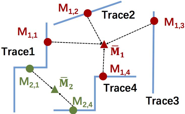 Figure 1: Traces are iteratively pulled and rotated until the "distance" between mutual WiFi markers is minimized.
3. Cleaning the Results
After merging, the system uses Barometer data to detect slopes/ramps, matching them to known building features to fix the absolute global coordinates. Finally, a 2D Histogram approach filters out "outlier" traces—random movements that don't represent a persistent walking path.
Experiments & Results
The researchers tested the system in a 6,656 shopping mall using five different smartphone models.
- Convergence: Even with traces randomly scattered and rotated (simulating total ignorance of the environment), the algorithm consistently converged in about 40 iterations.
- Path Accuracy: The final paths reached a mean accuracy of 2.1m. This is sufficient for most commercial LBS (Location Based Services).
 Figure 2: From chaos to clarity—the raw scattered traces (Fig 6 in paper) are successfully merged into the building's skeleton.
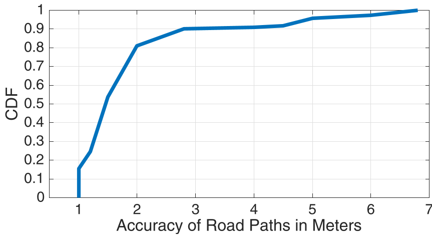 Figure 3: Accuracy distribution showing that 90% of the mapped points have less than 2.8m of error.
Critical Analysis
The Good: Unlike Graph-SLAM approaches that are computationally expensive for large datasets, WiFi-RITA’s rigid-body iterative approach is highly efficient. It solves the rotation and translation problem simultaneously without needing "loop closures."
The Limitations:
- WiFi Dependency: The system relies on a certain density of WiFi APs. In areas with sparse signals, the force-based alignment might weaken.
- Rigid Body Assumption: It assumes the shape of the PDR trace is mostly correct (rigid). If a user has massive step-length estimation errors, the "rigid" trace won't fit the actual floor plan well.
Conclusion
WiFi-RITA marks a significant step toward autonomous map generation. By converting a geometric alignment problem into a physics-based optimization, it handles the inherent messiness of crowdsourcing with elegant efficiency. For smart cities and large-scale indoor navigation, this "zero-effort" mapping approach is the most viable path forward.