
Crowdsourcing Accessibility: Turning Citizens into Urban Sensors
A crowdsourcing platform for the construction of accessibility maps
The paper introduces a crowdsourcing platform for building dynamic accessibility maps. It utilizes two mobile applications—Citizen Sensing (manual reporting) and Breadcrumb (passive sensor data)—to identify physical barriers and optimize urban mobility for people with disabilities (PwDs).
TL;DR
Navigating a city is a vastly different experience for a person with a disability compared to a non-disabled person. This paper by IBM Research presents a platform that creates dynamic accessibility maps by combining active citizen reports with passive sensor data from smartphones. By identifying where people slow down or detour, the system can automatically flag physical barriers and help city planners prioritize repairs.
Problem & Motivation: The "Invisibility" of Barriers
For most people, a light post in the middle of a sidewalk or a small set of steps is a minor inconvenience. For someone in a wheelchair or with visual impairments, these are major barriers that turn a simple commute into a complex puzzle.
The core problem is two-fold:
- Data Scarcity: City governments struggle to maintain an up-to-date catalog of every pothole or obstruction across vast urban landscapes.
- Lack of Context: Standard maps (like Google Maps) don't account for the "quality of experience" or specific locomotion challenges faced by People with Disabilities (PwDs).
The authors' insight is to treat every citizen as a "sensor," using the hardware already in their pockets to map the "pulse" of urban accessibility.
Methodology: Active vs. Passive Sensing
The platform rests on two distinct data collection strategies:
1. Citizen Sensing (The "What")
This is an active application where users manually report issues. A user sees a broken sidewalk, takes a photo, tags it (e.g., "inaccessible place"), and the GPS coordinates are sent to the server.
2. Breadcrumb (The "How")
This is a passive background service. It collects GPS, orientation, and accelerometer data every ten seconds. The magic happens in the Analytics phase:
- Speed Analysis: If a user's speed drops significantly in a specific area, it suggests an obstacle.
- Slope Correction: The system analyzes altitude data to ensure a speed drop isn't just someone walking uphill.
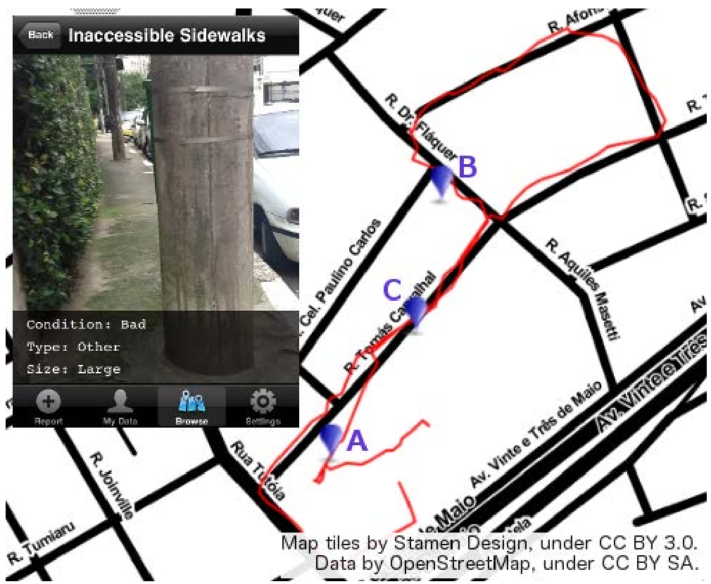 Figure 1: The Breadcrumb track (thin line) combined with Citizen Sensing reports (pins).
Experimental Insights: Seeing Through the Noise
During tests in São Paulo, the researchers encountered a common technical hurdle: GPS Noise. Smartphone GPS can be off by 20+ meters, making raw speed calculations look erratic.
The Solution:
- They applied a Simple Moving Average (SMA) over the last 10 measurements.
- They capped immediate speed values to filter out impossible outliers (e.g., jumping from 2km/h to 10km/h instantly).
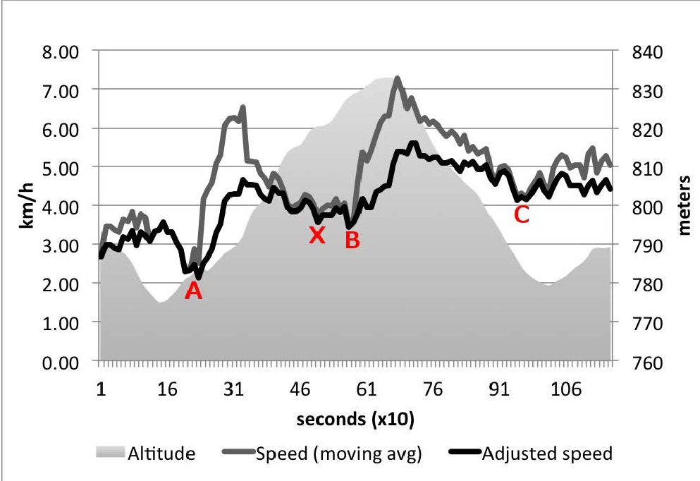 Figure 2: Correlating Altitude and Speed. Notice how points A, B, and C correspond to obstructions identified in the manual reports.
The data confirmed that speed decreases at points where obstacles (like a light post obstructing the path) forced a detour. However, it also caught "false positives"—like waiting at a crosswalk (marked "X" in the graph)—which emphasizes the need for high-volume data to differentiate between traffic stops and physical barriers.
Future Work: Sentiment and Prioritization
The IBM team is now looking at how to prioritize these issues. Not all barriers are equal. By using Sentiment Analysis on the voice and text comments submitted via Citizen Sensing, the platform could theoretically distinguish between a "annoying crack" and a "completely blocked route," allowing city administrations to deploy resources where they are most needed.
Conclusion
This work signals a shift from static mapping to participatory urbanism. By leveraging the ubiquity of smartphones, we can transform the lived experience of PwDs into actionable data, eventually leading to "pathfinding" algorithms that suggest routes based on the specific mobility needs of the user.
Key Takeaways:
- Passive sensing reduces user burden and provides more objective locomotion data.
- Context matters: Altitude data is essential to validate speed-based obstacle detection.
- Privacy first: The Breadcrumb app avoids collecting personal identifiers to encourage wider adoption.