
Scaling Geospatial Intelligence: A Distributed Crowdsourcing Architecture for Remote Sensing
A Crowdsourcing-Based Platform for Labelling Remote Sensing Images
This paper presents a web-based crowdsourcing platform designed for labeling high-volume remote sensing (RS) images. The system utilizes an adaptive grid partition method and Ceph storage to enable parallel data access and features a hybrid quality control mechanism combining expert validation with crowd participation to build large-scale training datasets for machine learning.
TL;DR
The explosion of remote sensing data has outpaced our ability to label it. This work introduces a cloud-native platform that solves the "Big Data" labeling bottleneck by combining adaptive grid-based image partitioning for high-speed rendering with a hybrid Expert-Crowd quality control system. It transforms the arduous task of downloading gigabytes of imagery into a seamless web-based experience for hundreds of thousands of users.
Problem & Motivation: The Annotation Bottleneck
In the era of Deep Learning, the bottleneck in Geosciences has shifted from data acquisition to data annotation. While missions like Sentinel and Landsat provide petabytes of imagery, existing human-labeled datasets (like UC Merced or RSSCN7) consist of only a few thousand samples—a drop in the ocean compared to the millions of parameters in a modern CNN.
The authors identify three critical technical hurdles:
- Data Gravity: Remote sensing images are too large for typical web browsers to handle without significant latency.
- Inconsistent Quality: Amateur labeling is often noisy, yet expert interpretation is too expensive to scale.
- Tooling Gaps: Existing platforms like Collect Earth Online often focus on point-based labeling, which is insufficient for Semantic Segmentation tasks requiring complex polygon boundaries.
Methodology: The Architecture of Efficiency
1. Adaptive Grid Design
To solve the latency issue, the authors proposed an Adaptive Grid Index. Unlike static tiling, this method aligns the grid origin with the image's coordinate system (e.g., UTM/EPSG:32649) and calculates offsets dynamically. This allows for:
- Parallelism: Concurrent reading and writing of data blocks.
- Elastic Expansion: Utilizing a Ceph cluster for distributed object storage, ensuring the platform scales as data grows.
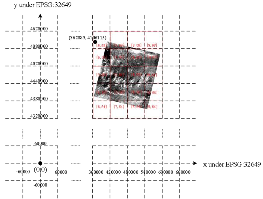 Fig 1. The mathematical framework for aligning pixel offsets to a global grid index.
2. Hybrid Quality Control
Random crowdsourcing often leads to "junk" data. The methodology employs a dual-layer approach:
- Expertsourcing: High-level researchers provide "Gold Standard" validation sets.
- Truth Inference: The system compares crowd labels against expert samples to calculate user reliability scores and refine the final dataset quality.
System Implementation & Results
The platform, integrated into GSCloud, utilizes a modern web stack: OpenLayers for the interactive frontend, Mapnik for on-the-fly rendering, and PostgreSQL for managing vector metadata.
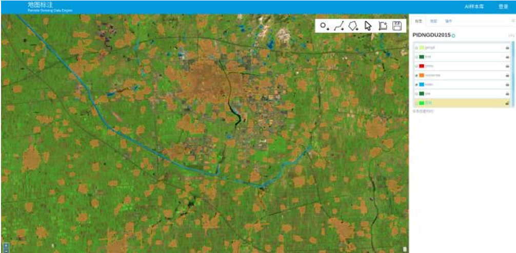 Fig 2. The web-based UX: Users can delineate Areas of Interest (AOIs) using polygons directly in the browser.
Key Outcomes:
- Zero-Footprint: Users label via web-connection without downloading heavy files.
- High Concurrency: The Python-based virtual file system supports fast, simultaneous access for a user base exceeding 347,000.
- Rich Geometry: Supports point, line, and polygon drawing, specifically designed for training semantic segmentation models.
Critical Analysis & Conclusion
Takeaway
This platform bridges the gap between massive raw satellite archives and the need for high-quality training data. By decentralizing the interpretation task and centralizing the data management via Ceph and Mapnik, the authors have created a "Data Factory" for the next generation of Earth Observation AI.
Limitations & Future Work
While the platform is robust, the current labeling process remains purely manual. A logical next step—often seen in modern SOTA—is AI-Assisted Labeling (e.g., using a pre-trained model to suggest boundaries that humans then refine). Additionally, incorporating "Active Learning" to prioritize the most "uncertain" images for the crowd would significantly increase the efficiency of the labeling pipeline.
Conclusion
The GSCloud labeling platform represents a vital infrastructure shift in Geosciences: moving from individual researchers working in silos to a collaborative, cloud-scale intelligence network.