
OpenGridMap: Reconstructing Hidden Power Grids Through Crowdsourcing and Spatial Intelligence
A Crowdsourcing Approach for the Inference of Distribution Grids
This paper introduces a crowdsourcing framework and a spatial inference algorithm to map hidden underground power distribution grids. By combining smartphone-collected data of surface devices (transformers, cable cabinets) with OpenStreetMap path data, the authors successfully reconstruct topological grid models with high accuracy.
TL;DR
Researchers from the Technical University of Munich have developed a way to "see" underground power grids by mapping what's on the surface. By combining a crowdsourcing smartphone app with a clever spatial inference algorithm, they achieved 88% accuracy in reconstructing the distribution topology of a Munich district without ever seeing a single physical cable.
Background: The Infrastructure Blind Spot
To shift towards green energy and electric vehicles, we need to simulate how local power grids handle new loads. However, there is a major bottleneck: Distribution System Operators (DSOs) rarely share their grid maps due to legal and security constraints. Furthermore, in countries like Germany, up to 87% of low-voltage cables are buried underground, making them invisible to traditional mapping.
This paper proposes a shift in perspective. Instead of waiting for official data, why not use the collective intelligence of citizens and the logic of urban planning to infer the grid's structure?
Methodology: From Surface Assets to Buried Topology
The approach works in two primary phases: Data Harvesting and Topological Inference.
1. The Crowdsourcing DNA
Using the OpenGridMap (OGM) platform, the authors organized a campaign where volunteers used a custom Android app to photograph and geo-locate grid components like transformers and cable cabinets.
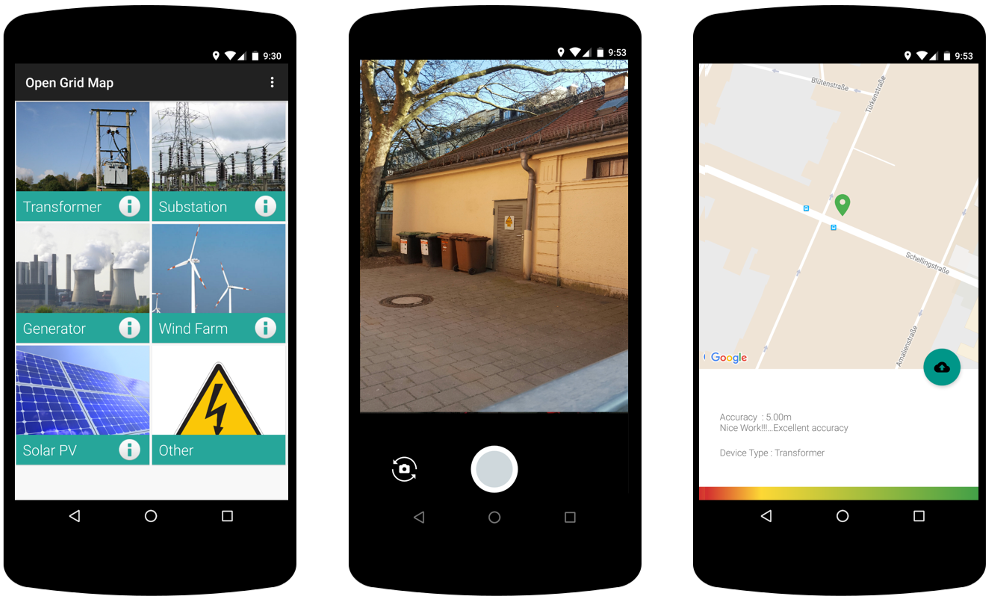 Figure 1: The OGM smartphone interface for data collection.
To ensure data quality, the framework employs an "Expert-in-the-loop" system. Experts review the crowdsourced photos to filter out mistakes (e.g., mistaking a telecom box for a power cabinet) and merge duplicate entries.
2. The Inference Algorithm
The core technical innovation is Algorithm 1, which treats grid reconstruction as a spatial optimization problem. The physical intuition is simple: Underground cables usually follow roads.
The steps are:
- Node Extraction: Identify consumer endpoints (buildings) and grid assets (transformers).
- Road Networking: Filter OpenStreetMap (OSM) data for pathways and intersections.
- Projection: Project the target grid nodes onto the nearest road segment.
- MST Calculation: Generate a Minimum Spanning Tree (MST) that connects all nodes using the road network as the primary "scaffolding."
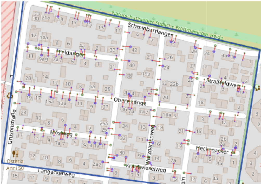 Figure 2: Projecting target nodes onto the nearest roads to create a viable grid graph.
Results: Can the Crowd Compete with the DSO?
The study conducted in Munich Freimann compared the inferred model against the SWM (local utility) ground truth.
- Participant Accuracy: Even without expert training, the crowd correctly identified ~75% of devices, with the best groups reaching 82% precision.
- Grid Reconstruction: Using official device locations, the algorithm achieved 88% cable length accuracy. Using purely crowdsourced data, the accuracy remained impressive at 75%.
 Table 1: Performance of DSO and OGM inferred models vs. Ground Truth.
Critical Insight & Future Directions
The beauty of this research lies in its Inductive Bias: the assumption that the grid's topology is constrained by human geography (roads). By encoding this constraint into an MST algorithm, the authors bypassed the need for expensive intrusive measurements like voltage correlation analysis.
Limitations:
- The Loop Problem: Real grids often include loops for redundancy, which a standard MST cannot capture.
- Invisibility: Some assets are behind private fences or in backyards, leading to lower recall.
What's Next? The authors suggest that future versions will use Deep Learning to automatically identify grid components from street-view images, further reducing the effort required from the crowd. If successful, this could create a global, open-source map of energy infrastructure—a "Wikipedia for the Power Grid."
Summary Takeaway
This paper proves that you don't need a utility's permission to understand the grid. By observing the surface and applying spatial logic, we can reconstruct the invisible infrastructure that powers our cities with surprising accuracy.