
Gamification and the Crowd: Scaling High-Precision In-Situ Data Collection
Crowdsourcing In-Situ Data Collection Using Gamification
This paper presents a suite of crowdsourcing and citizen science tools, notably "Picture Pile," designed for in-situ data collection and LULC (Land Use/Land Cover) validation. By leveraging gamification and street-level imagery, the authors successfully achieved a 98.7% accuracy rate in crop type classification through collective human intelligence.
TL;DR
Researchers at IIASA have demonstrated that "playing games" can solve one of the most tedious problems in remote sensing: the lack of high-quality training data for crop mapping. Using the Picture Pile application, they mobilized hundreds of volunteers to classify street-level imagery, achieving a staggering 98.7% accuracy that rivals official land surveys.
Context: The Bottleneck of Remote Sensing
While satellite imagery is becoming higher in resolution and frequency, our ability to interpret what is happening on the ground—in-situ data—hasn't kept pace. Machine learning algorithms for crop type mapping require thousands of labeled "ground truth" samples. Traditionally, this meant sending surveyors into the field (expensive) or relying on localized farmer declarations (often inconsistent).
The authors argue that the "missing link" is human visual interpretation powered by Gamification. By turning the identification of wheat, maize, and sunflowers into a rapid-fire mobile interface, they tap into the idle cognitive capacity of the global public.
Methodology: The "Picture Pile" Approach
The core of the study revolves around Picture Pile, a tool designed for the "rapid sorting" of images.
1. The Interface
Unlike complex GIS software, Picture Pile uses a "Tinder-style" mechanic. Users are shown a street-level photograph and must swipe toward the correct crop type or swipe down if uncertain. This reduces the cognitive load and allows for high-velocity data labeling.
2. Ensuring Quality via Consensus
A common critique of citizen science is "noise." The IIASA team mitigates this by:
- Majority Agreement: Each image is classified by multiple people (at least 8).
- Leaderboards: Highlighting top performers to foster competitive accuracy.
- Expert Control Points: Seeding known data into the workflow to "grade" and train volunteers in real-time.
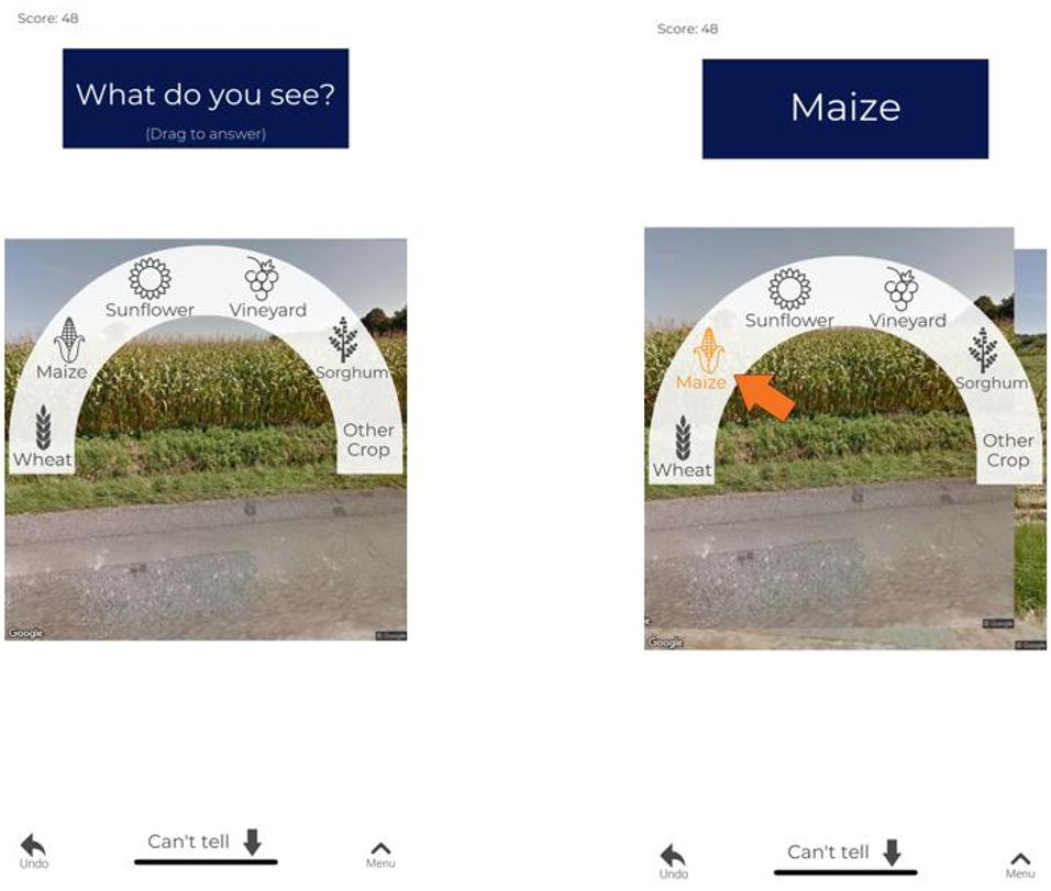 Figure 1: Screenshots of the Picture Pile application, demonstrating the intuitive mobile-first classification workflow.
Experimental Results: Better than the Pros?
The results from the Earth Challenge 2020 campaign are compelling. Comparing volunteer classifications against the official Land Parcel Information System (LPIS) in France, the findings were:
- Raw Accuracy: 63.1% (dragged down by "non-cropland" instances like harvested fields).
- Refined Accuracy: 98.7% when focused on identifiable growing crops.
- Expert Parity: In several cases, the crowd actually "corrected" official records where farmers had misdeclared their crops.
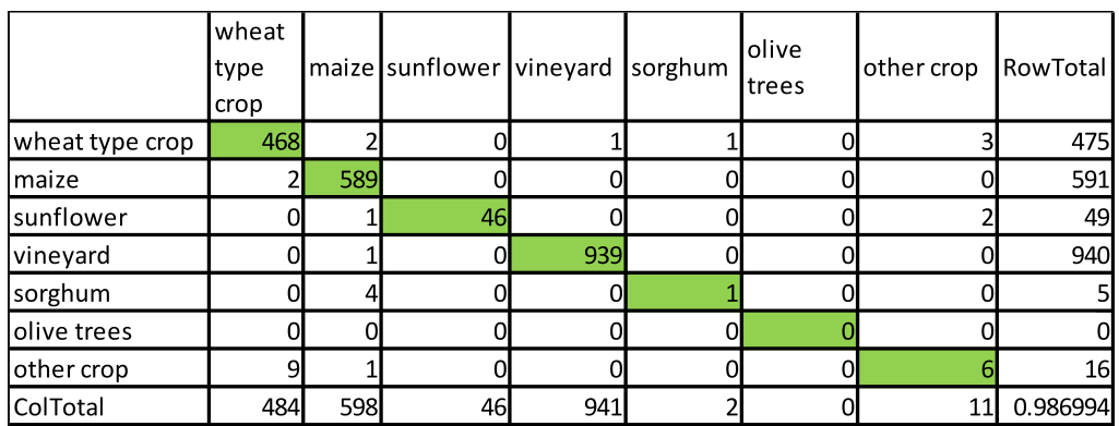 Table 1: Confusion matrix showing high diagonal values, indicating nearly perfect alignment between the crowd and parcel reference data.
Deep Insight: Why Why does this work?
The success of this method lies in the Inductive Bias of Human Vision. While a satellite might see "green pixels," a human looking at a Streetview image can easily distinguish the distinct structure of a vineyard versus a field of maize. When you aggregate these perspectives through a strict 5-of-8 consensus rule, the "noise" of individual errors cancels out, leaving behind a highly reliable signal.
Critical Analysis & Future Outlook
Limitations: The study notes that "early-season" crops are still difficult for the crowd. For instance, young sorghum is frequently mistaken for maize. Future iterations will need to integrate Crop Calendars to filter out images taken during growth stages that are visually ambiguous.
The Takeaway: The IIASA framework proves that we don't necessarily need more complex AI to get better data; we need better Human-in-the-Loop systems. By operationalizing workflows like the ESA-funded Euro Data Cube Crowd2Train, the research moves closer to a world where "crowdsourcing" is no longer a fringe experiment, but a standard, high-precision source of global environmental intelligence.