
Establishing Indoor Localization Databases: The Power of Quality-Aware Crowdsourcing
11811_A Localization Database Establishment Method Based on Crowdsourcing Inertial Sensor Data and Quality Assessment Criteria.
This paper proposes a localization database establishment method based on crowdsourcing inertial sensor data and quality assessment criteria. The core method is an anchor point-based forward-backward smoothing (FBS) algorithm combined with a quantitative framework that automatically filters high-quality crowdsourced data, achieving WiFi fingerprinting accuracy similar to supervised map-aided methods.
Executive Summary
TL;DR: Researchers have developed a way to build accurate indoor WiFi "maps" (fingerprint databases) without professional surveyors. By utilizing a "Forward-Backward Smoothing" algorithm and a smart quality-filtering framework, they can take messy, everyday smartphone data and extract trajectories nearly as accurate as supervised professional surveys.
Background: In the landscape of the Internet of Things (IoT), ubiquitous indoor positioning is the "Holy Grail." While WiFi fingerprinting is the standard, keeping its database updated is a logistical nightmare. This paper moves the field from "how do we get better sensors" to "how do we smartly pick the best data from the crowd."
The Problem: The Chaos of Daily Life Data
Indoor localization usually relies on Pedestrian Dead Reckoning (PDR). However, for a crowdsourced system, two things go wrong:
- Sensor Drift: Low-cost MEMS gyroscopes and accelerometers in smartphones cumulative errors quadratically or cubically over time.
- User Diversity: Data collected while a phone is swinging in a pocket is far more "noisy" than data from a phone held steadily.
Existing solutions often assume "constant speed" or require users to follow specific paths. This paper breaks those constraints.
Methodology: Smoothing and Scoring
The authors' approach is two-fold:
1. Forward-Backward Smoothing (FBS)
Instead of just calculating a path from start to finish, the system processes the data twice.
- Forward: Standard INS mechanization.
- Backward: The authors uniquely reverse the raw sensor data (compensating for gravity vectors), allowing the same forward algorithm to "walk backward" from the end anchor point.
- Fusion: These two paths are weighted-averaged. Since the error is lowest near the anchor points (start/end), the fused result is significantly more precise in the middle of the trip.
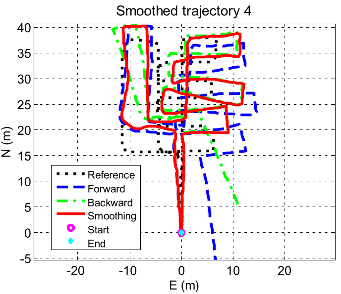 In the figure above, the red line shows the smoothed path, which tracks the black reference dots much more closely than the drifting green or blue individual paths.
2. Quantitative Quality Assessment
This is the "brain" of the system. It assigns a score to every uploaded trajectory:
- Motion Mode (): Detects if the phone was held steadily or swinging wildly.
- Gyro Bias (): Uses filter covariance to check how much the "heading" might be drifting.
- Time (): Shorter walks between anchor points are inherently more reliable.
Only the trajectories with the best (lowest) scores are used to update the WiFi database.
Experiments and Results
The system was tested in a massive shopping mall (160x60 m²) with 10 users and 10 different smartphone models.
- Automatic Filtering: Out of 300 random "daily life" trials, the framework automatically selected the most stable trajectories without human intervention.
- SOTA Comparison:
- Manual Map-Aided Survey: 5.4m error.
- Proposed Crowdsourcing: 6.3m error.
The difference is only ~0.9 meters, a negligible trade-off given the massive reduction in manual labor costs.
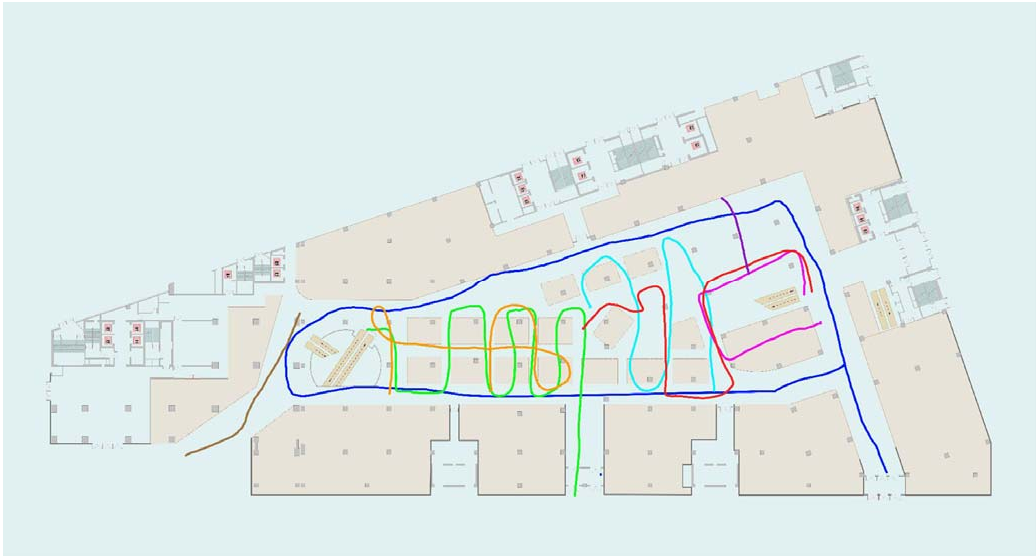 Experimental results show that the selected crowdsourced paths (left) create a grid-like database structure nearly identical to the professional survey (right).
Critical Insight & Future Work
Takeaway: The success of this method lies in its "Anchor Point" philosophy. By using GNSS or BLE beacons at entrances/escalators as "truth markers," and smoothing the sensor data in between, we can treat the entire indoor space as a self-correcting map.
Limitations: The current framework uses fixed weights for its score (). Future iterations could use machine learning to adapt these weights based on the specific building environment or phone model, potentially closing the 0.9m gap with professional surveys entirely.
Conclusion: This research provides a scalable blueprint for IoT-based localization. It proves that with the right mathematical "filter," the crowd's noise can be turned into a professional-grade navigation signal.