
BScanner: Re-imagining Urban Accessibility through Multi-Modal Crowdsourcing
A Crowdsourcing Platform for Constructing Accessibility Maps Supporting Multiple Participation Modes
The paper introduces BScanner, a multi-modal crowdsourcing platform designed to construct accurate and high-coverage accessibility maps. It integrates deep learning-based sensor analysis and gamification to lower participation barriers for diverse user groups.
TL;DR
BScanner is a novel crowdsourcing platform that tackles the "coverage vs. accuracy" dilemma in accessibility mapping. By offering four distinct participation modes—ranging from active manual reporting to passive, gamified sensor collection—it invites everyone, from the dedicated volunteer to the casual commuter, to help build safer cities for the elderly and impaired.
Academic Positioning: This work moves beyond simple "citizen sensing" by introducing a psychological framework for participant motivation, backed by a neural network capable of detecting sidewalk barriers with nearly 90% accuracy.
The Problem: The High Cost of Knowing Your Path
For a wheelchair user or an elderly person, a single 15cm step is not just a nuisance; it is a hard boundary. However, keeping maps of these "micro-barriers" updated is a logistical nightmare.
- The Limit of Street View: Google Street View images are often low-resolution, obscured by cars/trees, or years out of date.
- The Volunteer Gap: Most crowdsourcing apps (like Wheelmap or WheeLog!) require "High Motivation + High Free Time." If you are a busy office worker or someone who isn't inherently interested in urban planning, you likely won't contribute.
Motivation & Insight: The Four Quadrants of Participation
The authors categorize potential contributors into four quadrants based on Free Time and Motivation. To capture "The Rest of Us," they designed BScanner to be flexible:
- Reporter: The classic dedicated volunteer.
- Walker: The busy advocate (contributes sensor data while commuting).
- Gaming Reporter/Walker: The casual user (contributes while playing a location-based game).
Methodology: AI Meets Gamification
The technical heart of BScanner lies in its ability to turn a "walk to the grocery store" into a data-gathering mission.
1. The Sensor Intelligence
When a user selects the "Walker" mode, the app captures 3-axis acceleration and gyroscope data at 20Hz. A Convolutional Neural Network (CNN) processes these 3-second windows to identify seven distinct categories:
- Flat paths
- Up/Down Steps
- Up/Down Stairs
- High Slopes
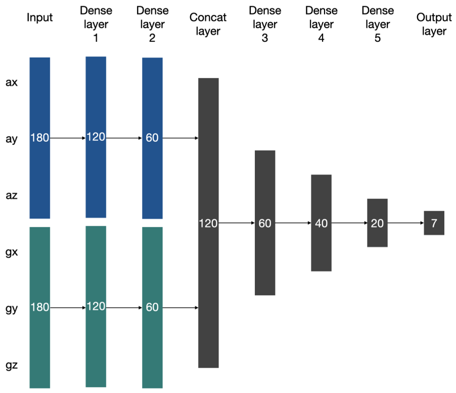
2. Gamification Theory
For those with low motivation, the app introduces Gaming Reporter (collecting monsters by photographing barriers) and Gaming Walker (a territory-conquest game similar to Ingress/Pokemon Go). This transforms a technical audit into an act of "expansion" and "collection."
Experiments & Results: Accuracy that Matters
The system doesn't just collect data; it filters it. In "Gaming Walker" mode, if a user starts running (which would corrupt the step-detection data), the game penalizes them, acting as a natural validation mechanism.
Key Performance Metrics:
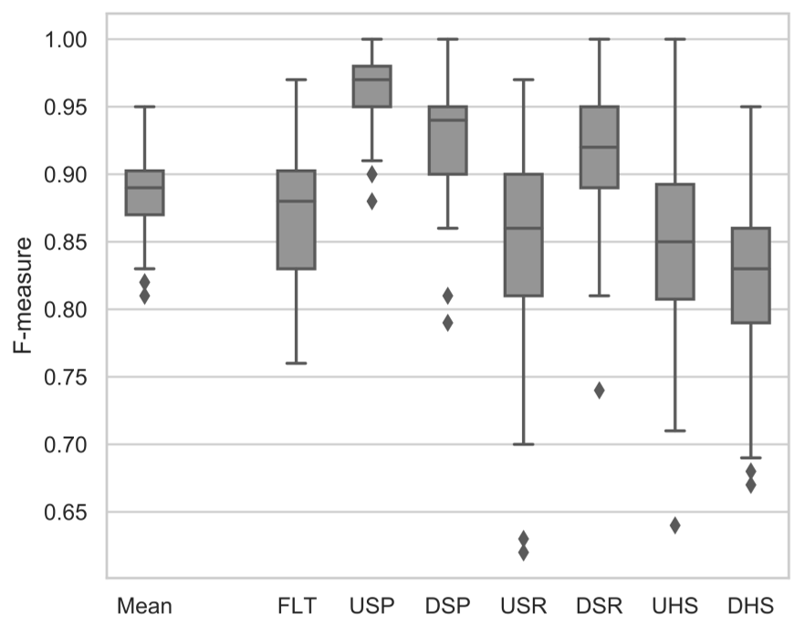
- Classification Accuracy: The neural network achieves an 0.89 F-measure.
- Visualization Hybridity: The platform uses a smart visualization strategy. Manual reports are shown as icons, while the vast amounts of sensor data are rendered as heatmaps, highlighting high-risk areas in red.
Critical Analysis & Conclusion
Takeaway
The genius of BScanner is not just in its AI, but in its Incentive Design. It acknowledges that "one size does not fit all" in crowdsourcing. By lowering the threshold to passive walking, the coverage of accessibility maps can expand exponentially.
Limitations
- Device Placement: Currently, the model assumes the phone is in a trouser pocket. Accuracy may drop if the phone is in a bag or a hand.
- Demographic Bias: The automated "Walker" modes follow able-bodied people. This means they might not capture the specific paths a wheelchair user must take, though the "Reporter" mode is intended to bridge this gap.
Future Outlook
The next step for this technology is integration with municipal "Smart City" initiatives. Imagine a city where garbage trucks or postal workers carry these sensors, automatically updating the city's accessibility health every single day.