
Crowdsourcing the Eye in the Sky: Can OSM Replace Manual Labels in Remote Sensing?
Can Crowdsourcing Support Remote Sensing Image Classification? A comparison of five methods for artificial surface identification
This paper evaluates the feasibility of using OpenStreetMap (OSM) crowdsourced data as a training source for Artificial Surface (AS) extraction from Landsat 8 satellite imagery. By comparing five classification methods, the study demonstrates that Neural Networks (NN) and Support Vector Machines (SVM) leveraging OSM labels significantly outperform traditional spectral indices and unsupervised clustering.
Executive Summary
TL;DR: This study investigates whether crowdsourced data from OpenStreetMap (OSM) can effectively train machine learning models for urban land-cover classification. By benchmarking five different algorithms on Landsat 8 imagery of Beijing, the research proves that combining crowdsourcing with Neural Networks can achieve over 93% accuracy in identifying man-made structures, vastly outperforming traditional spectral indices.
Positioning: This work bridges the gap between Volunteered Geographic Information (VGI) and conventional Remote Sensing (RS), advocating for a shift from manual expert labeling to automated, community-driven training pipelines.
The Core Motivation: The Bottleneck of Ground Truth
Monitoring urban expansion or "Artificial Surface" (AS) is critical for ecological and economic analysis. However, we face a paradox: satellite data is abundant, but high-quality "ground truth" labels are scarce and expensive to produce.
The authors identify that while traditional methods like the Normalized Differential Built-up Index (NDBI) are fast, they are notoriously unreliable in complex urban settings. Unsupervised clustering (like ISODATA) often fails to distinguish between shadows, water, and dark building materials. The insight here is to leverage the "Mapzens"—thousands of volunteers contributing to OSM—as a free, massive, and continuously updated training repository.
Methodology: Turning Vectors into Training Pixels
The technical challenge lies in the "mismatch" between high-resolution OSM vectors and 30-meter resolution Landsat pixels. The authors implement a robust preprocessing workflow:
- Negative Buffering: To account for GPS inaccuracies and the "edge effect" of 30m pixels, polygons are shrunk inward to ensure only "pure" interior pixels are selected for training.
- Attribute Sorting: Addressing the "Park vs. Building" overlap by prioritizing "purer" classes (e.g., a building inside a park is labeled as 'Building').
- Recursive Data Flow: Unlike traditional forward-only flows (Satellite -> GIS), this method uses existing GIS data to refine the processing of new satellite acquisitions.
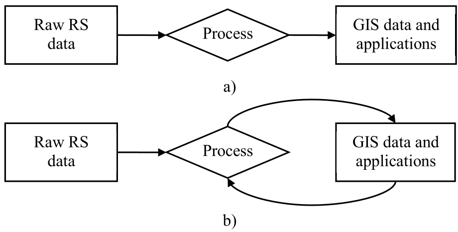 Figure 1: Comparison between traditional forward data flow and the proposed recursive crowdsourcing loop.
Experiments & Results: Supervised Learning Wins
The study compared five methods: NDBI, ISODATA, Maximum Likelihood (MLC), SVM, and Neural Networks (NN). The results were stark:
- The Failure of Spectral Indices: NDBI only caught 8.5% of artificial surfaces, proving it is highly insufficient for automated mapping without heavy local tuning.
- The Power of Non-Linearity: Both SVM and NN (Multilayer Perceptrons) showed superior performance.
- The Trade-off: While NN had the highest sensitivity (93.62% TPR), it tended to slightly over-estimate urban areas. SVM offered a more "conservative" and precise mapping with the highest True Negative Rate (95.65%).
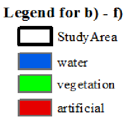 Figure 2: Visual comparison of results. SVM (e) and NN (f) provide the most detailed and accurate depictions of the urban fabric compared to the GLC30 reference.
Critical Insight & Outlook
The value of this paper isn't just in the 93% accuracy—it's in the verification of OSM as a reliable proxy for ground truth.
Limitations: The authors rightly note that OSM data is "sparse and uneven." In developing regions, OSM might be empty, leading to a "data desert" for model training. Furthermore, the 30m resolution of Landsat 8 limits the ability to detect small-scale urban features, regardless of label quality.
Future Work: The logical next step is moving toward Geo-object level extraction. Instead of classifying individual pixels, can we use OSM to train models that understand the "functional" use of a space—distinguishing an industrial zone from a residential block? This research provides the foundational evidence that the "crowd" is indeed ready to support the "satellites."