
SafeVi: Leveraging the Crowd to Map a Safer World for the Visually Impaired
A crowdsourcing approach to promote safe walking for visually impaired people
The paper introduces SafeVi, a crowdsourcing-based system designed to map hazardous walking areas—specifically stairways—to assist visually impaired individuals. By leveraging tri-axial accelerometer and GPS data from smartphones of visually normal volunteers, the system utilizes machine learning (SVM, Neural Networks) to identify stairway regions and provide acoustic alerts to users.
TL;DR
Navigating urban environments remains a high-stakes challenge for the visually impaired. While computer vision explores "seeing" obstacles, SafeVi takes a different path: it uses the collective motion data of the crowd. By analyzing accelerometer patterns from sighted volunteers, SafeVi automatically maps stairways and syncs this "safety topography" to an app that alerts visually impaired users via audio before they reach a hazard.
The "Invisible" Obstacle: Why Standard GPS Isn't Enough
Standard navigation apps tell you where you are, but they rarely tell you what is under your feet. For a blind person, a sudden flight of stairs is not just a waypoint—it’s a fall risk.
Previous solutions generally fell into two camps:
- Computer Vision (CV): High battery drain and requires the user to point the camera constantly.
- Specialized Sensors: Expensive IMUs that aren't practical for daily, large-scale deployment.
The authors' insight? Every smartphone is a sophisticated motion sensor. If we can recognize the "signature" of a person walking down stairs, we can mark that coordinate for everyone else.
Methodology: Turning Motion into Maps
The core of the system is a pipeline that transforms raw tri-axial acceleration into a binary "Stairway vs. Flat Road" classification.
1. Feature Engineering
The researchers didn't just look at raw -force. They extracted 9 key features, including:
- : The difference between consecutive samples to capture sudden impacts.
- Windowed Averages (): Providing temporal context to distinguish a single trip-up from a continuous stairway.
2. The Machine Learning Battle
The authors tested four classic algorithms: k-means, C4.5 Decision Trees, Neural Networks, and Support Vector Machines (SVM).
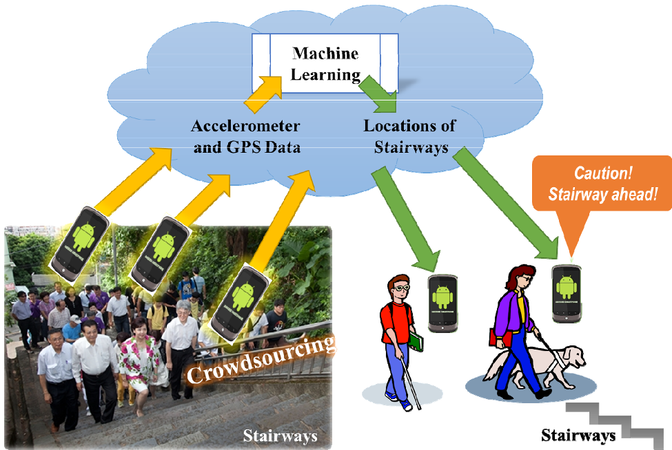 Figure 1: The Crowdsourcing Workflow — from volunteer collection to cloud analysis to end-user alert.
Key Findings: The "Downstairs" Signature
The data revealed a fascinating physical intuition: Going downstairs is much easier to detect than going upstairs.
- Why? The impact of the foreleg hitting the lower step creates a sharp acceleration spike that is absent during the smoother "lift" of going upstairs.
- Result: SVM achieved 81.79% accuracy on the Walk-vs-Downstairs dataset, significantly higher than the three-way classification (Walk/Up/Down).
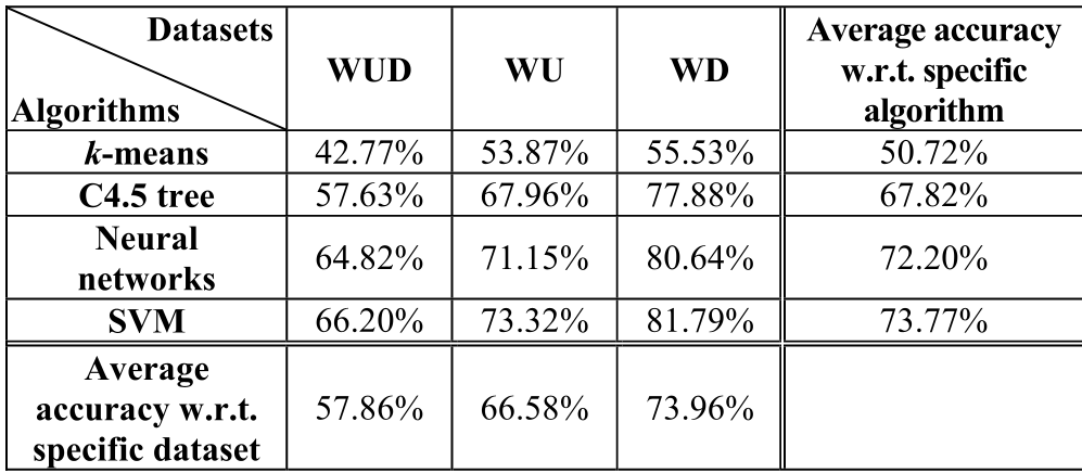 Table 1: Accuracy metrics across different datasets and algorithms.
Overcoming "Noise" with 1D and 2D Filtering
An 81% accuracy rate in a lab is one thing; in the real world, a "false alert" every 5 steps would make an app unusable. The authors propose two brilliant post-processing layers:
- 1D Correction: If a single "Down" state appears in the middle of 100 "Walk" states, the system logically ignores it as a sensor glitch.
- 2D Correction: Since this is crowdsourced, multiple people walk the same path. If 10 people walk a street and only 1 "detects" a stair, it’s discarded. Only "clusters" of detections become permanent markers on the map.
Critical Insight & Future Outlook
SafeVi proves that data volume can compensate for sensor noise. While an individual smartphone's accelerometer might be jittery, the collective data of 100 people walking the same street creates a high-fidelity "topographic signature."
Limitations & Moving Forward
- Battery Life: Constant GPS/accelerometer polling is a notorious battery killer. The authors suggest "motion-triggered" activation to save power.
- The Barometer Angle: In their conclusion, the authors point toward using barometers (pressure sensors) found in newer phones. Measuring altitude change directly would likely solve the "Upstairs vs. Walk" recognition problem that plagued this study.
Summary
SafeVi is more than an app; it is a shift toward Participatory Sensing. It turns every pedestrian into a silent guardian for the visually impaired community, proving that social-technical systems can solve accessibility problems that pure hardware cannot.
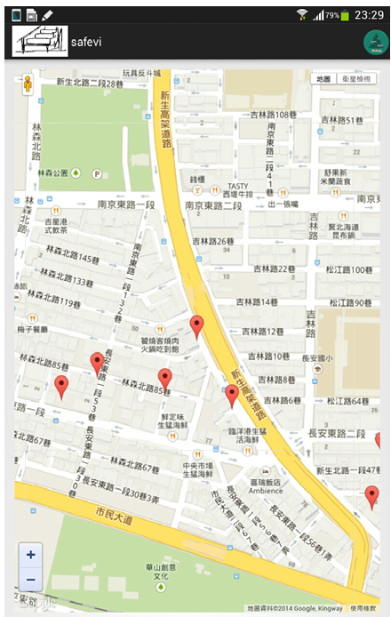 Figure 2: The SafeVi prototype showing manual marking (left) and the proximity alert system (right).