
Turning Noisy Walks into Maps: A Statistical Breakthrough in Indoor Crowdsourcing
Generating indoor maps by crowdsourcing positioning data from smartphones
The paper introduces a crowdsourcing-based server-side algorithm for the automatic generation and maintenance of indoor maps (floorplans) using smartphone positioning data. By employing a statistical approach based on "spatial density histograms with varied Gaussian kernels," the method transforms noisy (latitude, longitude, uncertainty) tuples from pedestrians into high-fidelity maps without requiring specific hardware or user cooperation.
TL;DR
Navigating indoors is often a "blind" experience because digital floorplans are hard to scale. This paper proposes a server-side algorithm that harvests standard (lat, long, uncertainty) data from any smartphone app to build maps automatically. By using spatial density histograms with varied Gaussian kernels, it filters out the "noise" of cheap sensors to reveal the underlying architecture of walls and hallways.
The Scalability Wall in Indoor Navigation
While GPS has mastered the outdoors, the indoors remain a fragmented frontier. Why? Because floorplans change constantly, manual mapping is expensive, and existing automated methods (like SLAM) ask too much of the user—expecting them to walk in loops or use specific hardware.
The core insight of this work is that we don't need perfect trajectories; we need a statistical critical mass. Thousands of "bad" trajectories, when viewed through the right mathematical lens, cancel out each other's errors to reveal the vacant spaces where humans can walk.
Methodology: The Power of Weighted Uncertainty
The authors reformulate mapping as a Kernel Density Estimation (KDE) problem. Unlike standard KDE which treats every data point equally, their "Varied Gaussian Kernel" approach handles the reality of smartphone sensors:
- Grid Discretization: The continuous world is chopped into a grid of "tiles" (approx. 66cm x 66cm).
- Uncertainty as Bandwidth: If a position fix is confident, it maps to a "sharp" Gaussian spike, adding high value to a specific tile. If a fix is noisy, it maps to a "flat" Gaussian, spreading its influence thinly across many tiles so it doesn't distort the local geometry.
- Vacancy Matrix: By accumulating these kernels, a "Vacancy Matrix" is formed. High-density areas represent walkable paths; low-density areas are likely walls or furniture.
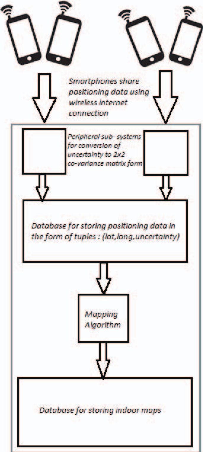 The system architecture: A centralized server processes heterogeneous positioning data to update a global map database.
From Probabilities to Floorplans
Once the server has a "heat map" of where people walk, it must draw the lines. The authors use -shapes—a mathematical generalization of the convex hull—to find the boundary of the pedestrian point cloud.
To prevent the maps from looking "jagged" due to the grid discretization, they introduced a Boundary Regularization Heuristic. By analyzing the angular deviation of strokes in the -shape, the algorithm merges small segments into long, straight walls, preserving structural intricacy only where necessary (e.g., at corners).
Experimental Results: Real-World Chaos
The researchers didn't use clean data. They collected 300 trajectories from Samsung Galaxy S-III phones held in hands, pockets, or swinging naturally. Many traces were objectively "garbage" due to magnetic interference in the hallway.
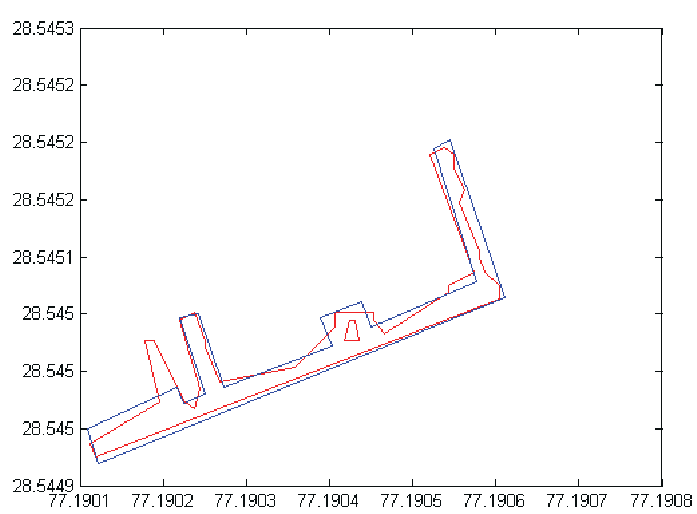 Comparison of estimated boundaries (red) vs. the original architectural floorplan (blue). Note that the algorithm successfully mapped a new extension of the building not present in the old blueprints.
The results were striking:
- Self-Updating: The algorithm identified a hallway extension that was added after the original building plans were drawn.
- Obstacle Detection: It successfully identified a small sitting arrangement in the middle of the hallway as an "island" of occupied space.
- Robustness: Despite individual Pedestrian Dead Reckoning (PDR) errors, the aggregate map was highly accurate.
Critical Insight & Future Outlook
This work shifts the burden of accuracy from the sensor to the algorithm. By acknowledging that every smartphone is a "noisy witness," and using Gaussian weighting to manage that noise, the authors provide a blueprint for a self-mapping planet.
Limitations: The current model assumes a 2D plane; future iterations would need to address multi-floor buildings (3D) and dynamic obstacles (like temporary kiosks). However, as a proof-of-concept for truly passive indoor crowdsourcing, it is a significant step toward a world where every "lost" pedestrian contributes to a better map for the next one.