
Empowering Indoor Positioning: Automated Multisource Database Construction via Crowdsourced Trajectories
Crowdsourcing Trajectory Based Indoor Positioning Multisource Database Construction on Smartphones
The paper proposes a crowdsourcing-based framework to construct multisource indoor positioning databases (Wi-Fi, Magnetic, and Image) using smartphone sensors. By fusing visual data (Structure from Motion, SfM) with inertial sensors (PDR), the system reconstructs user trajectories and geo-tags fingerprints without requiring prior floorplans or extensive site surveys.
TL;DR
The labor-intensive "site survey" remains the Achilles' heel of indoor localization. This paper introduces a breakthrough crowdsourcing framework that transforms ordinary smartphones into high-precision mapping tools. By fusing visual data (SfM) with inertial sensors, the system automates the creation of Wi-Fi, magnetic, and visual databases with a calibration accuracy of 0.67m, matching the performance of professional manual surveys.
The Bottleneck: Why "Free" Positioning is Costly
Fingerprinting-based localization (Wi-Fi, Magnetic, Visual) is ubiquitous because it doesn't require specialized hardware. However, it relies on a Radio Map—a dense database of signals mapped to coordinates. Creating this map traditionally requires professional surveyors to walk through every inch of a building, a process that is:
- Time-Consuming: Taking days for large malls.
- Brittle: Any change in the environment (moved routers, shifted furniture) renders the map obsolete.
- Inaccurate in Wide Spaces: Traditional Pedestrian Dead Reckoning (PDR) suffers from massive "drift" in open areas where landmarks are scarce.
Methodology: Fusing Vision and Motion
The core innovation lies in the Visual-Inertial Trajectory Recovery. Instead of relying solely on the noisy gyroscope of a smartphone to determine heading, the authors look through the camera lens.
1. Heading Estimation via SfM
The system extracts SIFT features from video frames. By calculating the Fundamental Matrix (F) and Essential Matrix (E) between adjacent frames, it derives a Rotation Matrix (R). This allows the system to calculate the change in heading () with far higher stability than a gyroscope.
2. Geometry Reconstruction
The relative location of each sampling point is calculated using: where is the step length estimated from the accelerometer.
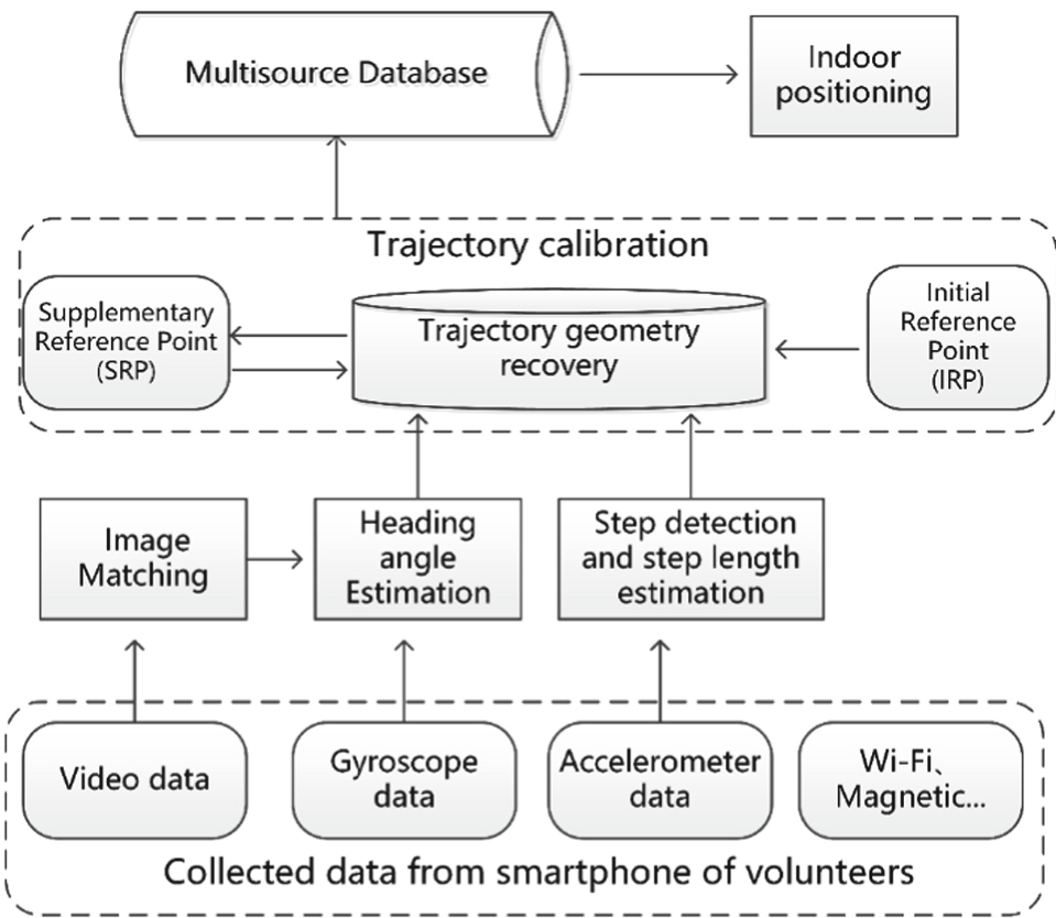 Figure 1: The framework of multisource database construction using crowdsourced trajectories.
3. Spatial Calibration (The Anchor Point)
To move from "relative" geometry to a "global" coordinate system, the authors use an Initial Reference Point (IRP). When a user's video matches the IRP, Bundle Adjustment (BA) is applied to refine the trajectory. Once a trajectory is calibrated, its points become Supplementary Reference Points (SRPs) for other overlapping trajectories, creating a "ripple effect" of calibration across the building.
Experimental Results: Professional Performance from Crowdsourced Data
The authors tested the system across four different routes, comparing their hybrid approach against "Gyroscope-only" and "SFM-only" methods.
- Trajectory Accuracy: The fused method achieved an average error of 0.53m, significantly outperforming the GT method (Gyroscope) which deviated by several meters.
- Localization Performance:
- RSS (Wi-Fi): As more crowdsourced trajectories (R1 to R5) were added to a grid, the error dropped from 4.3m to 3.2m, approaching the 2.6m accuracy of a professional site survey.
- Visual: The image database achieved a staggering 1.2m average error, thanks to the high spatial sampling rate of the video.
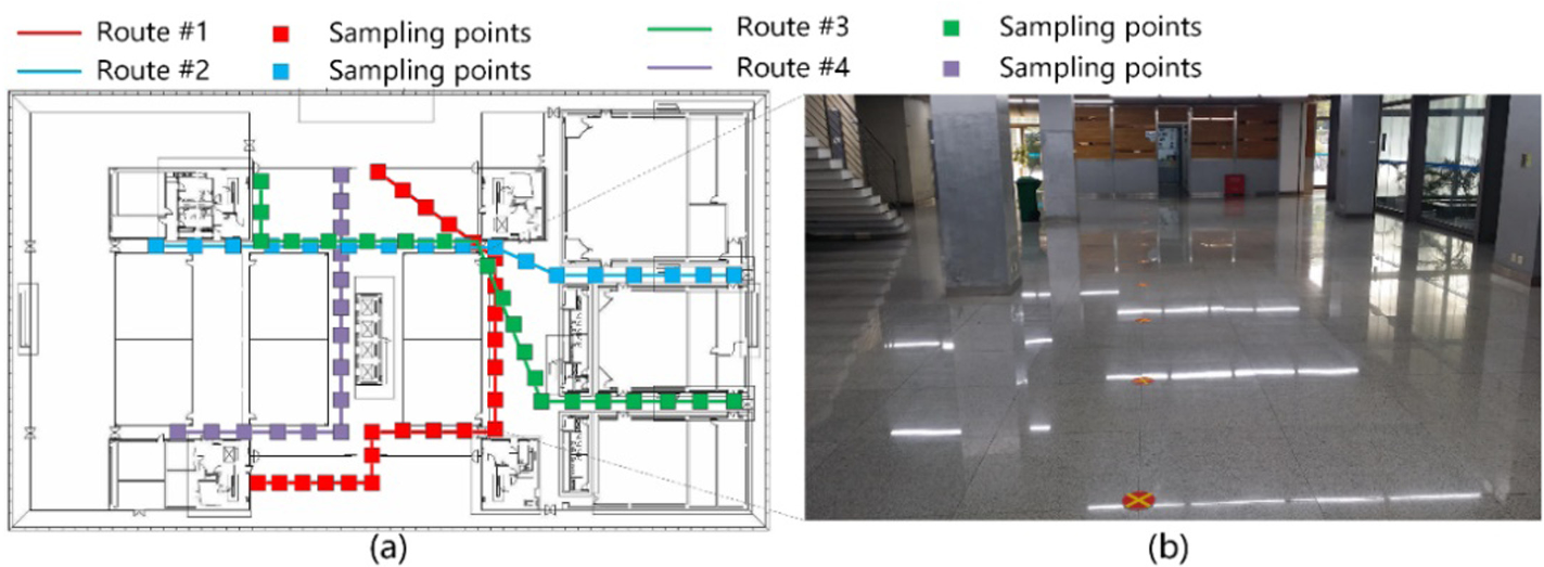 Figure 2: The CDF of Errors. The fusion method (solid line) shows the lowest Shape Discrepancy Metric (SDM).
Critical Insights & Takeaways
- Visual is the Key: This paper reinforces that vision is no longer just a "positioning mode"—it is a critical "mapping utility." Using video frames to correct PDR drift is the most viable path to scalable crowdsourcing.
- The "Data Density" Effect: The study proves that crowdsourced data follows a law of diminishing returns; once 4-5 trajectories cover an area, the map quality stabilizes at professional levels.
- Limitations: The method assumes users keep their cameras forward-facing (fixed posture). Future work must address "pocket-mode" or diverse holding postures to truly democratize the data collection process.
Conclusion
By removing the requirement for floorplans and laser-based 3D modeling, this approach makes Large-Scale Indoor Localization (LSIL) commercially viable for shopping malls, airports, and underground garages where manual maintenance was previously too expensive.