
Maximizing Situational Awareness: A Metadata-Driven Framework for Disaster Crowdsourcing
Effectively crowdsourcing the acquisition and analysis of visual data for disaster response
The paper proposes a unified crowdsourcing framework for disaster response that optimizes the acquisition and analysis of mobile video data. It introduces a "metadata-first" mechanism and an analytical model for "Visual Awareness Maximization" (VAM) to prioritize critical data transmission under bandwidth constraints.
TL;DR
In the chaos of a disaster, communication is a luxury and time is life. This paper introduces a framework that prioritizes "metadata-first" transmission to identify the most critical video data from mobile devices. By treating video acquisition as a "Visual Awareness Maximization" problem and balancing analyst workloads using Kd-trees, the system ensures that the most urgent information reaches responders first, even when bandwidth is crippled.
Background & Motivation: The Paradox of More Data
During catastrophes like the Haiti or Nepal earthquakes, field reports often flood in. However, more data does not equal better awareness. The authors identify two primary failures in current systems:
- The Bandwidth Bottleneck: High-quality video is heavy, yet disaster zones often have damaged cell towers. Indiscriminate uploading leads to congestion and the loss of critical footage.
- The Analyst Bottleneck: Platforms like GeoQ assign analysts to static regions. If one region is a "hotspot" of activity, that analyst is overwhelmed while others remain idle.
The core insight of this work is that geospatial metadata (location, direction, viewable angle) is lightweight and sufficient to decide which videos are worth the bandwidth before the actual pixels are ever sent.
Methodology: Visual Awareness and Selective Sensing
1. Metadata-First Mechanism
The system decouples metadata (a few bytes) from video content (megabytes). When a user records a video, the quintuple metadata is uploaded immediately. This allows the control center to visualize coverage maps in real-time and request only the contents that provide the highest "Visual Awareness."
2. The Visual Awareness Maximization (VAM) Problem
The authors define Visual Awareness (VA) as the probability a video covers an incident. It is a function of the work cell's urgency () and the video's coverage area.
- Video-level VAM: Modeled as a 0-1 Knapsack problem (NP-hard), solved using dynamic programming to fit the most "aware" videos into a fixed bandwidth budget.
- Frame-level VAM: To further save bandwidth, the system can select individual keyframes. This is modeled as a Weighted Maximum Coverage Problem, using a greedy algorithm to minimize redundant overlaps between frames.
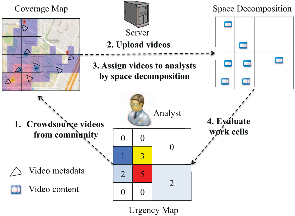 Figure 1: The unified framework fusing selective data acquisition with balanced spatial analysis.
3. Adaptive Spatial Partitioning
To prevent analyst burnout, the framework moves away from uniform grids. It uses Kd-trees and Quadtrees to split the disaster area based on video density. This ensures that each analyst receives roughly the same number of videos to review, regardless of geographical size.
Experiments & SOTA Comparison
The authors tested their framework using synthetic datasets simulating Uniform, Gaussian, and Zipfian (skewed) distributions of disaster data.
Key Findings:
- Balanced Workload: As shown in the variance metrics, the Kd-tree partitioning consistently produces an even distribution of tasks compared to the baseline uniform grid.
- Efficiency Gains: On highly skewed (Zipfian) data, the adaptive techniques outperformed Grid-based methods by two orders of magnitude in terms of visual awareness captured.
- Frame Optimization: By selecting individual frames instead of entire video files, the system achieved a 10x improvement in information density per MB of bandwidth.
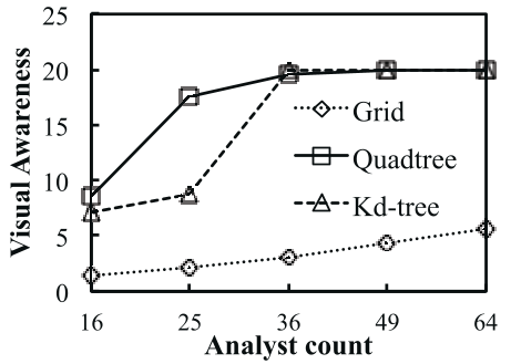 Figure 2: Performance of Kd-tree vs. Grid as the number of analysts increases across different data distributions.
Critical Insight: The Future of Crisis Management
This research highlights a shift from "Big Data" to "Smart Data" in emergency response. The ability to calculate the value of data before collecting it is a game-changer for edge computing in volatile environments.
Limitations & Future Work: While the metadata model is robust, the current framework relies on manual urgency tagging by analysts or pre-defined social heatmaps. The next leap for this technology will be integrating on-device computer vision to extract semantic metadata (e.g., "smoke detected") to further refine the Visual Awareness calculation without human intervention.
Conclusion
By leveraging the spatial properties of mobile video and treating disaster response as a constrained optimization problem, this work provides a scalable blueprint for saving lives through efficient information management.