
TDMS: Decoding Urban Vitality Through Cycle Periodic Running Patterns
Cycle Periodic Behavior Detection and Sports Place Extraction Using Crowdsourced Running Trace Data
This paper introduces a novel framework for automatically detecting cycle periodic behavior and extracting urban sports places (LOI, AOI, POI) from crowdsourced running traces. The researchers developed the Trajectory Distance Matrix Search (TDMS) algorithm to identify repetitive movement patterns and utilized Delaunay Triangulation to delineate physical sports infrastructures.
TL;DR
Understanding how residents use urban spaces for exercise is crucial for smart city planning. This paper presents a robust method to extract "cycle periodic" behaviors—like running laps in a stadium—from noisy crowdsourced GPS data. By moving away from rigid grid-based analysis and instead using a Trajectory Distance Matrix Search (TDMS), the authors achieved a 91.5% F-measure in detecting exercise patterns and successfully mapped hundreds of sports locations across Beijing.
Context: Why Traditional Mining Fails for Runners
Most trajectory mining research focuses on "A-to-B" movement, such as commuting from home to work. However, sports behavior is inherently cyclical and localized. Existing methods like the Apriori algorithm or Fourier Transforms face three major hurdles in this context:
- Resolution Sensitivity: Grid-based methods fail when an entire running session happens within a single 500m x 500m cell.
- Irregularity: Human runners don't maintain a perfect "metronome" rhythm; fatigue and pauses create noise that breaks signal-processing models.
- Semantic Fuzziness: Distinguishing a runner doing laps from a person wandering aimlessly in a park requires precise geometric modeling.
Methodology: The TDMS Breakthrough
The core innovation lies in the Trajectory Distance Matrix Search (TDMS). Instead of treating the trajectory as a single string of characters, the authors decompose it into two-dimensional time series data () and ().
1. Key Point Extraction
The system identifies peaks and troughs in the coordinate time series. These "Key Points" represent the extreme boundaries of a runner's loop, significantly reducing the computational load for the distance matrix.
2. The Distance Matrix
The algorithm constructs an upper triangular matrix where each cell evaluates a potential sub-track. It checks for three specific features:
- Trajectory Path Distance: Must be (to avoid small-scale noise).
- Trajectory Direction Distance: Must be near zero (indicating the runner returned to the start point).
- Time Duration: Minimum thresholds to ensure it was a sustained activity.
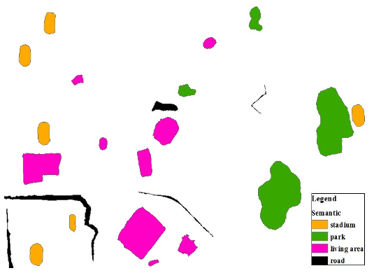 Fig 1: Decomposing track lines into time series and the resulting search points.
3. Spatial Extraction via Delaunay Triangulation
Once periodic tracks are identified, they are aggregated. The authors use Delaunay Triangulation (DT) to "shrink-wrap" these tracks. By filtering out global and local long edges in the triangulation, they can precisely extract the Line of Interest (LOI) (the track path) and the Area of Interest (AOI) (the sports field).
Experiments & Results
The researchers applied this to a massive dataset: 15,786 trajectories from Beijing sports App users.
Superior Performance
When compared to the traditional Apriori baseline, TDMS showed staggering improvements:
- Precision: 88.3% (TDMS) vs. 51.8% (Apriori).
- Time Efficiency: TDMS processed the test batch in 21.3 seconds, while Apriori took 65.1 seconds.
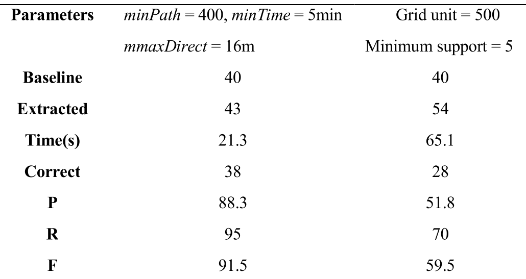 Table 1: Benchmark results showing TDMS outperforming the baseline in every metric.
Mapping Beijing's Pulse
The method extracted 573 sports places, including:
- 255 Living Communities: Proving most people run close to home.
- 139 Stadiums & 68 Parks: Identifying the formal and informal "green lungs" of the city.
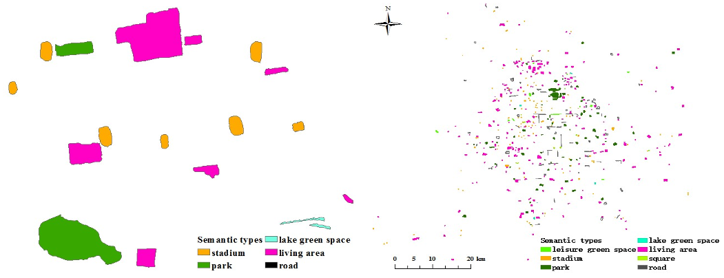 Fig 2: Extracted sports places categorized by semantic type (Park, Stadium, Road, etc.).
Critical Insight & Conclusion
The beauty of this approach is its Inductive Bias. By encoding the physical intuition that "a lap ends where it began" into a distance matrix search, the authors bypassed the "grid resolution" trap that has plagued spatiotemporal mining for a decade.
However, the study relies on high-frequency sampling (1s-10s). As privacy-preserving techniques might coarsen future datasets, the next challenge will be adapting TDMS for sparse or "lossy" crowdsourced data.
Final Takeaway: This is a masterclass in using geometric constraints to solve a semantic problem. For urban planners, this provides a dynamic heatmap of where a city actually breathes and moves.