
Multi-Dimensional Alignment: Solving the Chaos of Indoor Crowdsourcing
Data Fusion and Alignment for Location-Aware Crowdsourcing Applications
This paper introduces a multi-dimensional data fusion and alignment framework for indoor location-aware crowdsourcing applications. By combining heterogeneous sensory data (Wi-Fi, geomagnetic fields, and environmental factors), the method employs an iterative optimization approach to align noisy and distorted spatial traces without requiring prior floorplans or extensive infrastructure.
TL;DR
The paper addresses the "spaghetti trace" problem in indoor crowdsourcing—where data from different users is scattered, noisy, and spatially distorted. The authors propose a framework that uses multi-sensory dimensions (Wi-Fi, Magnetic, Temp) and a novel 8-directional chain coding system to iteratively align these traces into a high-quality ambient map. The result is a significant boost in indoor localization accuracy without needing a pre-existing floorplan.
Context: Why is Indoor Fusion So Hard?
While outdoor crowdsourcing enjoys the luxury of GPS, indoor environments are a "black hole" for location accuracy. Existing solutions often fall into two traps:
- Fixed Infrastructure Dependence: Requiring thousands of pre-installed beacons or fingerprints (Site Surveys).
- Single-Dimension Weakness: Methods and SOTA like Walkie-Markie rely heavily on Wi-Fi landmarks. If you walk a short path or the Wi-Fi signal is "flat," the system breaks.
The authors' insight is simple yet powerful: Physical parameters (like magnetic fields) have unique gradients. Even if sensors are noisy, the "trend" of the data across multiple dimensions should be consistent if two users walk the same path.
Methodology: The Core Engine
The framework operates as an iterative solver focused on Mutual Correlation.
1. Multi-Resolution Ambient Maps
Different data types change at different rates. Temperature is "coarse" (low resolution), while Wi-Fi signals are "fine" (high resolution). The system uses a quadtree-based pyramid structure to store these dimensions, assigning weights based on their location sensitivity.
2. Trace Coding & Transformation
Instead of processing raw coordinates, which are prone to floating-point errors and complexity, the authors project paths into an 8-directional chain code. This discretizes the problem, making transformations like rotation and scaling mathematically "cheap."
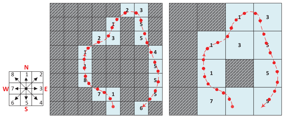 Fig 1: Converting raw movement into discrete 8-directional codes for robust optimization.
3. The Iterative Solver
The system treats alignment as a hunt for the maximum Correlation Gain. It moves and stretches "floating" traces until they snap into place against "rooted" traces (those with a known starting anchor like a building entrance).
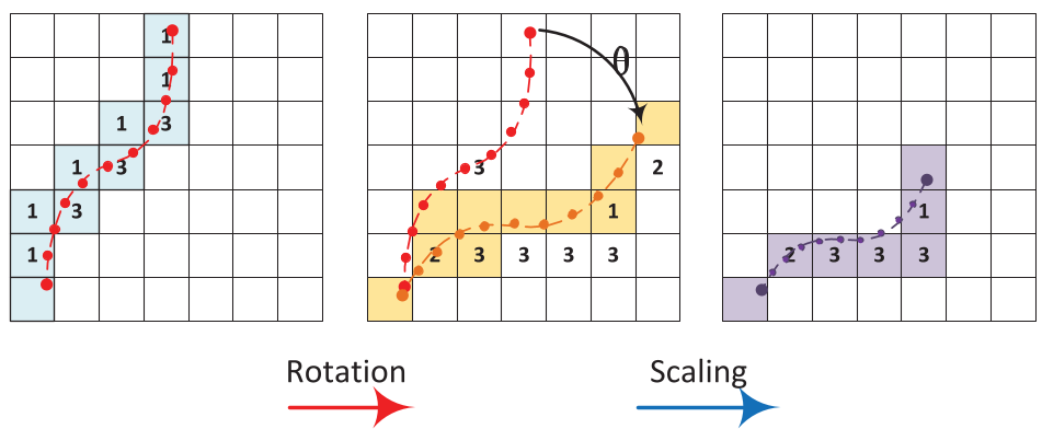 Fig 2: Affine transformations applied to traces: Rotation, Scaling, and Translation.
Experiments & Results
The system was tested in a 4,000 m² lab with volunteers using various Samsung and HTC devices.
- The Visualization: Raw traces often drift outside building boundaries (due to Dead Reckoning accumulation errors). Post-fusion, the traces align closely with the actual corridors and office layouts.
- Quantifiable Accuracy: 90% of fused points stayed within a 1.6m error margin (2 cells), which is impressive for a system that doesn't use a professional site survey.
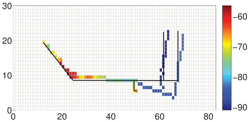 Fig 3: Comparison of noisy raw traces vs. the reconstructed pathway after multi-dimensional alignment.
Critical Insight & Conclusion
The real value of this paper is the move away from absolute values toward relative trends. By focusing on the variation trend (Pearson Correlation) rather than the raw RSSI or Gauss values, the system becomes agnostic to different smartphone hardware—a major hurdle in real-world Crowdsourcing.
Limitations: The system still struggles in "open spaces" (like massive exhibition halls) where movement isn't constrained by corridors, reducing the overlap probability of traces. Future work could likely integrate Graph Neural Networks (GNNs) to model these spatial relationships more dynamically.
Final Takeaway: Multi-dimensional sensory data isn't just "extra info"—it's the key to correcting the fundamental geometric distortions of mobile sensing.