
From Coordinates to Context: Decoding Human Behavior with Semantic Trajectories
Data & Knowledge Engineering
The paper proposes a modular, ontology-based pivot model for representating and querying heterogeneous trajectory data. By utilizing OWL-DL formalism, it integrates geographic and application-specific semantics to transform raw GPS coordinates into "Space-time paths" with behavioral insights.
TL;DR
Movement is more than a sequence of coordinates; it is a story of human intent. This paper introduces an Ontology-based Pivot Model that bridges the gap between raw GPS data and semantic understanding. By partitioning knowledge into Geometric, Geographic, and Application modules, the researchers enable complex behavioral queries—like "Who stopped for coffee before going to the lab?"—that traditional databases struggle to answer efficiently.
The Semantic Gap in Mobility Data
For decades, the Geographic Information Science (GIS) community has treated trajectories as "Geospatial Lifelines"—simple lines in a space-time cube. While Moving Object Databases (MOD) like SECONDO have mastered the geometry, they remain "semantic-blind." They know where an object is, but not what it is doing.
The challenge is twofold:
- Structural Heterogeneity: Data comes in various forms (raw points, regions of interest, structured segments).
- Semantic Heterogeneity: A "stop" in a park is a "leisure activity," but a "stop" at a red light is a "traffic delay." Context is everything.
Methodology: The Modular Pivot Model
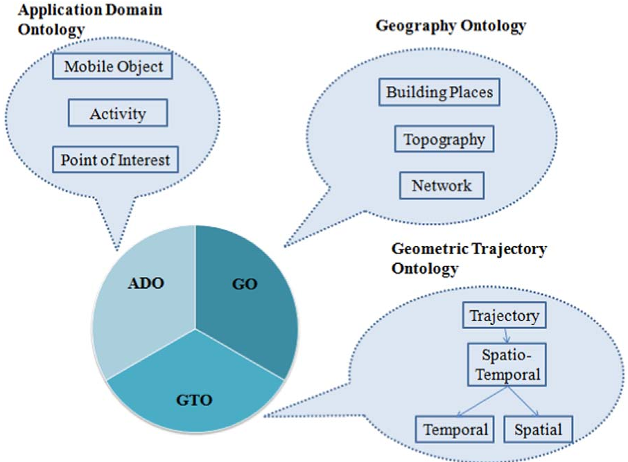
The authors move beyond flat data structures by proposing a Modular Ontology using OWL-DL (Web Ontology Language - Description Logic). This allows for formal reasoning and automated inference.
1. The Geometric Module
This is the foundation. It reuses W3C’s Time-owl and Geo ontologies to define spatial primitives (Point, Line, Region) and temporal ones (Instant, Interval). It formalizes five levels of trajectory representation:
- Raw Trajectory: Points and timestamps.
- Structured Trajectory: Segments partitioned into Begin, Move, Stop, End.
- Trajectory with ROI: Movement defined by visited Regions of Interest.
- Semantic Trajectory: Links stops to Points of Interest (POIs).
- Space-time Path: The highest level, annotating movement with specific activities (e.g., "Phone Call").
2. Geographic & Application Modules
These layers provide the "World View." The Geographic Module describes the environment (roads, buildings, lakes), while the Application Module defines the actors (pedestrians, vehicles) and their specific behaviors.
Experimental Validation: The Edinburgh Case Study
The authors applied their model to a dataset of pedestrians in the Edinburgh Informatics Forum. Using Oracle's semantic technologies, they transformed raw camera-tracked coordinates into a semantic knowledge base.
Query Efficiency and Intuition
The power of this approach shines in query execution. In traditional SQL, finding a pedestrian who "received a phone call" requires manual spatio-temporal joins between movement tables and activity logs. In the proposed semantic framework, the relationship is pre-inferred.
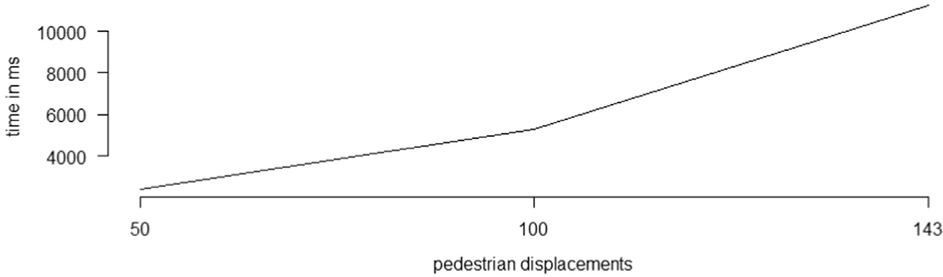 Figure: The data shows that while initial preprocessing takes time, the semantic integration significantly reduces the complexity and execution time of high-level behavioral queries.
Critical Analysis & Takeaways
This work effectively transitions trajectory modeling from a data-storage problem to a knowledge-representation problem.
Strengths:
- Interoperability: The pivot model acts as a "Rosetta Stone" for different trajectory formats.
- Reasoning: Through OWL-DL, the system can automatically classify a segment as a "Stop" based on duration thresholds, without explicit manual labeling.
Limitations:
- Scalability of Inference: While Oracle Semantic technologies were used, real-time reasoning on millions of moving objects remains a computational bottleneck.
- Dynamic Context: The current model assumes relatively static POIs and geographic features.
Future Outlook: As we move toward "Digital Twins" of cities, this modular ontology provides a necessary scaffold. Integrating this with Machine Learning—where ML detects the activity and the Ontology validates the logical consistency—represents the next frontier in Spatio-Temporal AI.