
Elevating Environmental Risk Monitoring: From Simple Thresholds to Data-Driven Intelligence
A Data Mining Application for Monitoring Environmental Risks
The paper presents a data mining system for monitoring environmental risks such as floods and landslides in Italy. It utilizes classification trees applied to the Italian National Hydro-geological database, aiming to outperform existing threshold-based warning systems.
TL;DR
This paper introduces a sophisticated data mining framework designed to protect the Italian territory from hydro-geological disasters like the Sarno catastrophe of 1998. By replacing rigid, single-point threshold alerts with inductive classification trees, the system can identify complex risk patterns—such as the cumulative effect of long-duration moderate rainfall—that traditional systems miss.
The Motivation: Moving Beyond Static Thresholds
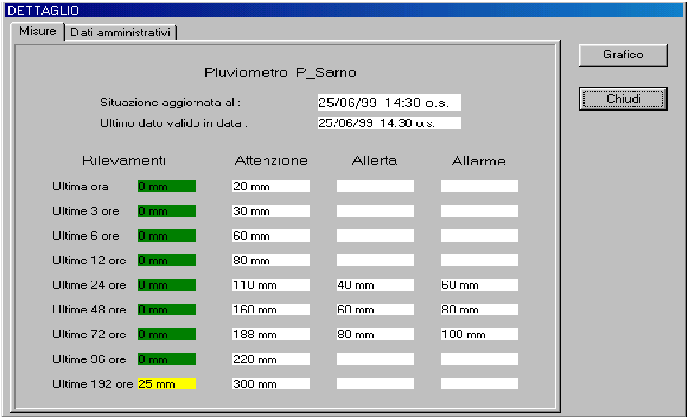
In Italy, a country historically vulnerable to landslides and floods, the "Servizio Idrografico e Mareografico Nazionale" manages millions of data points across sensors measuring rainfall, temperature, and river levels.
Historically, risk was assessed via a binary threshold system: if a sensor hit a certain value, an alarm was triggered. This approach is fundamentally flawed because it ignores:
- Persistence: Moderate rain over 72+ hours can be more dangerous than a heavy burst over 1 hour.
- Complexity: Multiple sensors across a basin may show moderate levels that collectively signal a systemic disaster.
- Interpretability: Authorities need to know why an alert is triggered, making "black-box" models like neural networks less desirable for public safety decisions.
Methodology: The Power of Monotonic Classification Trees
The core of this work is the application of Classification Trees to a "low prevalence" problem—where the vast majority of data points represent "no risk," and the critical samples (disasters) are rare.
1. Feature Engineering (The Temporal Window)
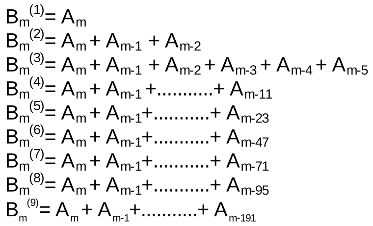
Instead of looking at a single point in time, the model constructs features based on cumulative rainfall over sliding windows of 1, 3, 6, 12, 24, 48, 72, 96, and 191 hours. This captures the systemic saturation of the soil.
2. The Monotonicity Constraint (M)
The author introduces a physical intuition into the model: The Monotonicity Property. If one sequence of rainfall levels is strictly greater than or equal to another, the resulting risk level must also be equal or greater. By enforcing this, the model remains robust and prevents "counter-intuitive" predictions where more rain somehow results in less reported risk.
3. Cost-Sensitive Metrics
In environmental safety, a False Negative (an unpredicted flood) is infinitely more costly than a False Positive (a false alarm). The model's metric optimizes the decision nodes by applying high penalties to missed events, ensuring that the tree prioritizes "anticipation" over "precision" where necessary.
Performance & Critical Insights
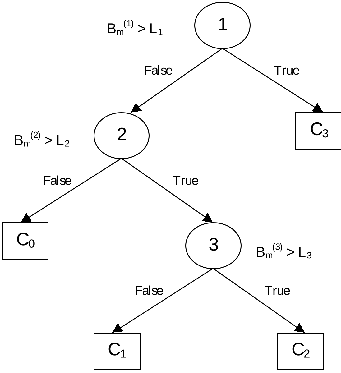
The system transforms raw ASCII sensor data into a relational database capable of generating real-time vector maps. By training the trees on a subset of historical data (learning set) and validating on a disjoint "test set," the author demonstrates that the data-mined rules provide better discrimination between "Attention," "Alert," and "Alarm" phases than the previous legacy system.
Key Takeaways for the Academic Coordinate System:
- Domain-Infused ML: The work is a prime example of how adding domain constraints (like monotonicity) can make a simple model (Decision Tree) more effective than a complex one.
- Interpretability over Hype: In 1999, despite the rise of neural networks, the author chose Decision Trees specifically because the "user has access to the decision procedure"—a requirement that remains critical in modern AI Safety.
Limitations and Future Outlook
While effective, the system is hindered by its reliance on a single-location view. The author notes that future iterations should integrate weather forecasts—moving from reactive detection to proactive prediction—and group data by hydrological basins rather than administrative departments to better reflect the physical reality of water flow.
Despite being an early application of data mining (1999), the logic of cost-weighted metrics and temporal windowing remains the bedrock of modern environmental monitoring.