
Unified Spatial Intelligence: Mining Geographical Accessibility for Tourism
Data Mining of Geographical Accessibility for Tourism in Regional Area
The paper proposes a unified framework for evaluating geographical accessibility in tourism by merging Spatial Interaction Models and Discrete Choice Models using a Mixture of Experts (MoE) neural network. This approach utilizes the entropy maximization principle and reinforcement learning concepts (Z-learning) to model customer preferences and facility utility from road network adjacency data.
TL;DR
This research bridges the gap between how we measure physical distances (Spatial Interaction) and how humans make decisions (Discrete Choice). By leveraging a Mixture of Experts (MoE) model and Entropy Maximization, the authors transform simple road connection data into a sophisticated "Geographical Advantage" index, providing a path to optimize tourism facility locations using Reinforcement Learning logic.
Problem & Motivation: Beyond the Gravity Law
Since the 1930s, urban planning has relied on the "Law of Retail Gravitation"—the idea that a city's influence is proportional to its size and inversely proportional to distance. While intuitive, this "Newtonian" approach fails in the modern era of complex tourism.
The problem is two-fold:
- Fragmented Models: Existing models treat the facility's spatial reach and the customer's personal preferences as separate problems.
- Linear Limits: Traditional gravity models often struggle with qualitative factors—like the "vibe" of a tourist spot or the specific demographic of the traveler.
The authors' insight? Accessibility is a hidden state. It isn't just about the shortest path; it's about the probability of a choice being made under the constraints of a road network.
Methodology: The Unified MoE Framework
1. From Road Nodes to Geographical Weights
The first step is transforming geography into math. By representing a road network as an Adjacency Matrix (A), the authors calculate the maximum eigenvalue. This identifies which nodes are structurally dominant.
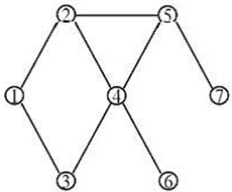 Figure: Geographical weights derived from the structural shape of the road net.
2. The Entropy Maximization Principle
The paper posits that spatial interactions follow an entropy maximization principle. In simple terms, systems naturally move toward the most probable distribution. By applying Lagrange multipliers, they derive an interaction formula: This allows them to define Accessibility from both the customer’s and the facility’s perspective.
3. Mixture of Experts (MoE) Integration
The core innovation is using an MoE model—a type of probabilistic neural network—to handle individual preferences. Here, "Experts" look at different attributes (age, travel time, assortment) and a "Gating Network" determines which expert's judgment matters most for a specific geographical node. This turns the Discrete Choice Model into a learnable function.

Experiments & Results: Z-Learning for Tourism
The researchers take a bold step by linking spatial choice to Reinforcement Learning. They frame the selection of a tourist destination as a solution to the Bellman Equation.
By introducing "Optimal Control Rules," they show that "Geographical Advantage" () can be derived from the transition probability matrix. This mimics Z-learning, where an agent (the tourist) navigates a network to maximize a "Reward" (the tourism experience), while the model learns to quantify the true accessibility of each location.
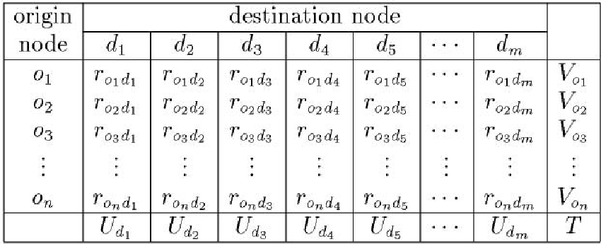 Table: The Origin-Destination (OD) matrix used to calculate interaction volume.
Critical Analysis & Conclusion
Takeaway
The study successfully unifies Utility, Preference, and Accessibility. It proves that by treating regional tourism as a data mining problem, we can move away from "best guesses" about facility placement to a mathematically rigorous "Geographical Advantage" score.
Limitations
- Data Sparsity: The model relies heavily on the Adjacency Matrix. In regions with poor road data, the "Geographical Advantage" might be skewed.
- Computational Complexity: Using MoE and RL solvers for large-scale regional networks (thousands of nodes) could be computationally expensive for real-time planning.
Future Outlook
The integration of Linearly-solvable Markov Decision Processes (MDPs) into urban planning marks a shift toward "Smart Cities." Imagine a real-time tourism app that adjusts recommendations not just based on your likes, but based on the dynamic accessibility of the entire city's network—effectively distributing traffic to prevent overcrowding while maximizing visitor satisfaction.