
Beyond Coordinates: Redefining Urban Spaces with Geo-Social Clustering
Density-Based Place Clustering Using Geo-Social Network Data
The paper introduces DCPGS (Density-based Clustering Places in Geo-Social Networks), a novel spatial clustering framework that integrates geographic proximity with social network ties and temporal check-in data. By extending the DBSCAN paradigm, it achieves superior coherence in grouping places visited by socially connected users.
TL;DR
In the world of Location-Based Social Networks (LBSNs), a "place" is more than just a latitude and longitude—it is defined by the people who visit it. This paper introduces DCPGS, a framework that upgrades traditional density clustering (DBSCAN) by injecting social relationships and temporal dynamics into the distance metric. It allows researchers to find clusters that are socially "dense" even if they are spatially scattered, or to split clusters that are physically close but socially worlds apart.
Background: Why Euclidean Distance Isn't Enough
If two cafes are on opposite sides of a river with no bridge nearby, DBSCAN might put them in the same cluster simply because they are 50 meters apart. However, if the people visiting Cafe A and Cafe B belong to entirely different social circles and never cross paths, should they truly be grouped together?
The authors argue that traditional spatial clustering ignores the Inductive Bias of human movement: we visit places because of our social ties and specific time-bound habits.
Methodology: The Geo-Social Distance
The core innovation is the hybrid distance function:
Where:
- : Normalized Euclidean distance.
- : Social distance based on "Contributing Users"—people who have visited both places or users who visited different places but are friends in the social graph.
1. Handling the Arrow of Time
Static clusters are often deceptive. The authors propose three ways to incorporate time:
- Damping Window: Weighted towards the present. Recent check-ins matter more.
- Temporally Contributing Users: Only counts social ties if the visits happened within the same time window (e.g., the same week).
- History Frames: Capturing how a neighborhood "pulse" changes from working days to weekends.
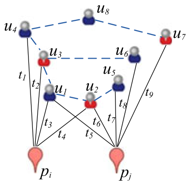 Figure 1: Illustration of how social friendships (dashed lines) and check-ins (solid lines) define the relationship between two places.
Experimental Insights: Splitting the Inseparable
The paper uses real-world data from Gowalla and Brightkite to prove that DCPGS sees what others miss:
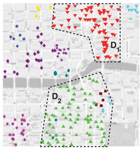
- Barrier-Based Splitting: DCPGS successfully splits clusters separated by rivers (as seen in the Manhattan/Chicago case studies) because the social connectivity across the water is low, even if the Euclidean distance is small.
- Spatially Loose Clusters: It identifies "social hubs"—groups of places that are somewhat farther apart but visited by a very tight-knit community.
- Fuzzy Boundaries: Unlike the rigid partitions of DBSCAN, DCPGS acknowledges that social groups often overlap spatially.
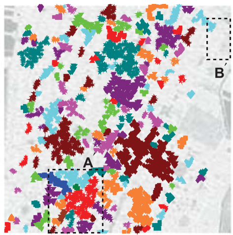 Top-left (a) shows DCPGS identifying distinct social regions, while (b) shows DBSCAN merging them or missing sparse hubs.
Quantitative Validation: Social Entropy
To prove these clusters weren't just "visually nice," the authors developed Social Entropy. A lower entropy signifies that a cluster’s visitors primarily belong to the same social community. DCPGS consistently outperformed SimRank, Jaccard, and standard Graph Clustering in maintaining low entropy across various cluster sizes.
 Experimental results showing DCPGS consistently maintaining superior social coherence (lower entropy) compared to baselines.
Critical Analysis & Future Outlook
Takeaway: This work bridges the gap between purely spatial GIS and purely social network analysis. It demonstrates that the social graph provides a vital "hidden dimension" for understanding urban geography.
Limitations:
- The complexity of calculating social distances for millions of pairs is high (though the authors offer optimized algorithms in the appendix).
- Dependency on check-in density: In areas with sparse digital footprints, the social signal may become noise.
Future Prospects: Integrating this with Semantic Tagging (e.g., check-in comments) could allow us to cluster not just based on who is there, but what they are doing (e.g., "coffee culture" clusters vs. "nightlife" clusters).