
DCPGS: Beyond Geometry — Why Your Social Network Defines Where You Belong
Density-based place clustering in geo-social networks
The paper introduces DCPGS (Density-based Clustering Places in Geo-Social Networks), which extends the DBSCAN paradigm to group spatial locations by integrating Euclidean distance with social network connectivity. It leverages a novel social distance measure and a high-performance grid-based partitioning algorithm to achieve state-of-the-art efficiency on large-scale geo-social datasets like Gowalla and Brightkite.
TL;DR
Spatial clustering just got a social upgrade. Researchers from The University of Hong Kong have developed DCPGS, a density-based clustering model that doesn't just look at how close two places are on a map, but how connected the people visiting them are. By blending geographical distance with social graph data, they’ve unlocked a way to find "hidden" urban communities that traditional GPS-only models miss.
Problem & Motivation: The "Blind Spot" of Coordinates
Traditional spatial clustering algorithms like DBSCAN treat the world as a purely geometric plane. If two restaurants are 50 meters apart, they belong in the same cluster.
The catch? This ignores the human element. Two spots might be physically adjacent but separated by a river, a social barrier, or a demographic divide. Conversely, two trendy cafes 500 meters apart might share the exact same social circle, making them part of a single "social neighborhood" despite the distance. Traditional models fail here—they either merge what should be separate or discard sparse social hubs as "noise."
Methodology: The Geo-Social Fusion
The core of this research is the DCPGS (Density-based Clustering Places in Geo-Social Networks) model. It redefines the concept of "neighborhood" using a hybrid distance function:
- The Social Distance (): Instead of complex graph proximities like SimRank, the authors use a lean, effective measure called Contributing Users. If users visiting Place A also visit Place B, or if they are friends with people visiting Place B, the social distance shrinks.
- Physical vs. Social Weight (): This allows the model to prioritize either the "physical walkability" or the "social vibe" of a cluster.
Architecture & Optimization
To make this run on real-world data (millions of check-ins), the authors moved beyond standard R-tree indexing. They introduced DCPGS-G, a grid-based approach.
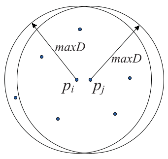 In the figure above, (a) shows how nearby spatial queries overlap, creating waste, while (b) demonstrates the efficiency of a grid-based search space.
Experiments: Seeing the Unseen
The authors validated their model using Manhattan’s Gowalla data. The results were striking:
- Barrier Recognition: DCPGS correctly split clusters separated by the East River that DBSCAN clumsily joined.
- Spatially Loose, Socially Tight: It identified clusters in sparsely populated areas where the visitors were extremely tight-knit—places DBSCAN would have labeled as "outliers."
To quantify this, they introduced Social Entropy. A lower entropy means a cluster's visitors come from a unified social community.
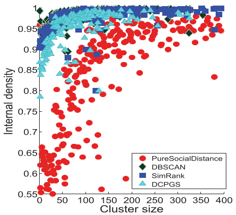 The charts demonstrate that DCPGS consistently achieves lower Social Entropy (higher social purity) compared to DBSCAN and graph-based models.
Critical Insight & Future Outlook
The genius of this paper lies in its simplicity. By avoiding computationally heavy metrics like SimRank or Katz similarity and opting for a "Contributing Users" count, they made geo-social clustering feasible for massive datasets.
Limitations: The model currently treats a check-in as static. It doesn't yet account for when people visit. A place that’s a business hub at 10 AM might be a social club at 10 PM. Adding a temporal dimension is the logical next step.
The Takeaway: For urban planners and marketers, DCPGS offers a high-definition lens. It’s no longer just about "Location, Location, Location"—it’s about "Location, Socials, Location."