
Designing Mobile Public Safety: Beyond Static Maps to Crowdsourced Intelligence
Designing a mobile system for public safety using open crime data and crowdsourcing
This paper presents the design and deployment of an Android mobile system for public safety at Syracuse University, integrating open crime data with crowdsourcing. The authors developed an app in collaboration with the Department of Public Safety (DPS) to visualize safety incidents and investigated behavioral "nudges" to encourage real-time civilian reporting.
TL;DR
This research addresses the gap between historical crime data and real-time public safety needs. By co-designing a mobile app with the Syracuse University Department of Public Safety (DPS) and conducting cognitive psychology experiments, the authors identify that contextual factors—like proximity to home and time of day—are critical "nudges" that can overcome the human tendency to under-report safety incidents.
Background: The Latency of Open Data
While many municipal governments have embraced "Open Data," the reality of public safety data is often a "look in the rearview mirror." Most official crime reports suffer from a 4-7 week lag, making them descriptive of trends but useless for immediate situational awareness. The authors argue that for a mobile safety system to be truly effective, it must transition from a passive information portal to an active crowdsourcing platform.
Problem & Motivation: The Under-Sharing Dilemma
The researchers identified two primary hurdles:
- The Ghost Town Effect: Merely aggregating old police reports (as seen in their initial app launch) failed to gain traction because the information wasn't "live" enough to change behavior.
- Psychological Barriers: Reporting a crime is high-friction. Privacy concerns and "social loafing" lead to under-sharing. The authors sought to find the "Nudge"—the specific architectural choice that encourages a user to hit "Report."
Methodology: Co-Design and Behavioral Labs
The study followed a dual-track methodology: professional system deployment and psychological validation.
1. The SU DPS App Architecture
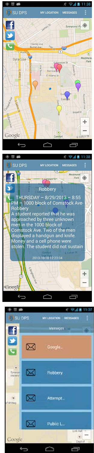
The system was built to provide a unified interface for campus alerts (Orange ALERT), historical crime mapping via Google Maps, and direct social media integration with the police.
2. The Behavioral Experiment
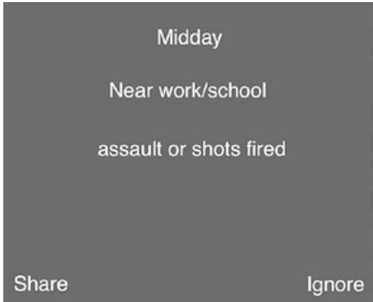
To solve the sharing problem, the authors ran a controlled lab experiment using Matlab and Psychtoolbox. They manipulated three variables:
- Time: Morning, Afternoon, Late Night.
- Location: Home, Campus, Downtown.
- Severity: Low (theft), Medium (assault), High (robbery with weapon).
Key Insights: What Makes Humans Report?
The results from the experiment provided a roadmap for "Nudge" features:
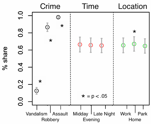
- Severity is King: Not surprisingly, heavy crimes are reported more reliably.
- Temporal and Spatial Bias: People are much more sensitive to safety during late nights and when an incident happens near their private residence. Interestingly, Response Time (RT) was faster in these high-stakes scenarios, suggesting a lower cognitive hurdle for sharing when the perceived personal threat is higher.
Critical Analysis & Conclusion
The paper honestly acknowledges the difficulty of "Design in the Wild." Their initial deployment only reached 70 users, proving that Utility ≠ Adoption.
Takeaway for Future Systems: The future of public safety apps isn't just better maps; it's Context-Aware Nudging. By proactively asking for reports when a user is in a "high-concern" context (e.g., walking home late at night), systems can significantly increase the data flow into the platform.
Limitations: The study's initial lab sample was small (11 participants), and the collaboration with official law enforcement, while providing "ground truth" and trust, inherently slows down the iteration speed of "risky" experimental features.
Future Work
The authors suggest that future versions of the app will explicitly use messages like "You are X meters from home—notice anything unusual?" to lower the psychological barrier to reporting, effectively turning the community into a distributed sensor network for safety.