
From Grids to Parcels: Revolutionizing Soil Mapping with AI and Geo-Entities
Digital Mapping of Soil Available Phosphorus Supported by AI Technology for Precision Agriculture
This paper introduces a novel digital soil mapping (DSM) framework based on geo-parcels rather than traditional grids, specifically designed for precision agriculture. Using a modified VGG16 (RCF) for boundary extraction and machine learning (RF and ANN) for spatial modeling, the method achieves hyper-local soil available phosphorus prediction in Zhongning County, China.
TL;DR
Digital Soil Mapping (DSM) is evolving. This study moves away from traditional, computationally expensive grid-based systems to a geo-parcel based framework. By leveraging Deep Learning for automated field boundary extraction and Machine Learning for nutrient prediction, the researchers reduced mapping units by 50% while providing actionable insights for precision fertilizer management.
Background: The Mismatch in Precision Agriculture
For decades, the "Grid" has been the king of spatial data. However, in the context of a farm, a square pixel doesn't exist; "parcels" (management units) do. Traditional grid-based DSM often ignores physical boundaries like roads and irrigation canals, resulting in maps that are visually "noisy" and practically difficult for autonomous machinery to interpret.
The author's core insight is that AI can bridge the gap between pixels and entities. By treating the farm as a collection of semantic objects (geo-parcels) rather than a sea of pixels, we can align scientific modeling with real-world operation units.
Methodology: The Two-Tier AI Approach
1. Extracting the "DNA" of the Landscape
The first step involves identifying where one field ends and another begins. The researchers employed a modified Richer Convolutional Features (RCF) network, a deep learning model derivative of VGG16, specifically tuned for edge detection.
- Innovation: They dropped the
pool3layer to retain high-frequency edge details essential for fine-grained boundary detection in high-resolution (GF-2) satellite imagery.
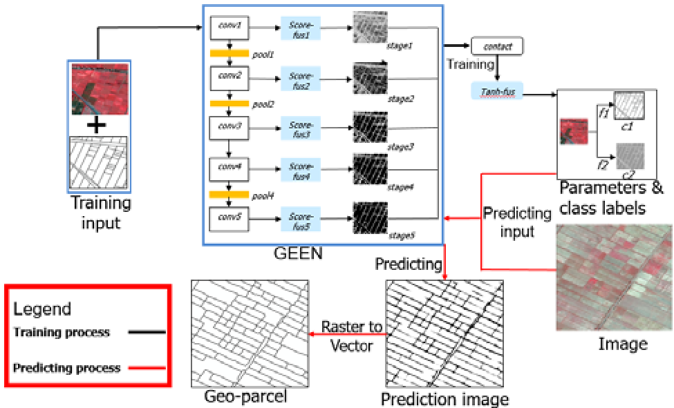
2. Intelligent Feature Aggregation
Once boundaries were defined, the system performed "Scale Transformation." Instead of predicting every pixel, it calculated the average or majority value of environmental covariates (Elevation, Slope, NDVI, Climate) within each parcel. This significantly compresses the data footprint without losing the semantic "essence" of the land.
Experiments and Results: Efficiency Meets Accuracy
The study focused on Soil Available Phosphorus in Zhongning County, Ningxia.
- Computational Win: For an equivalent area, a 20m grid required 173,433 units. The geo-parcel approach reduced this to 46,678 units—a reduction of over 50%.
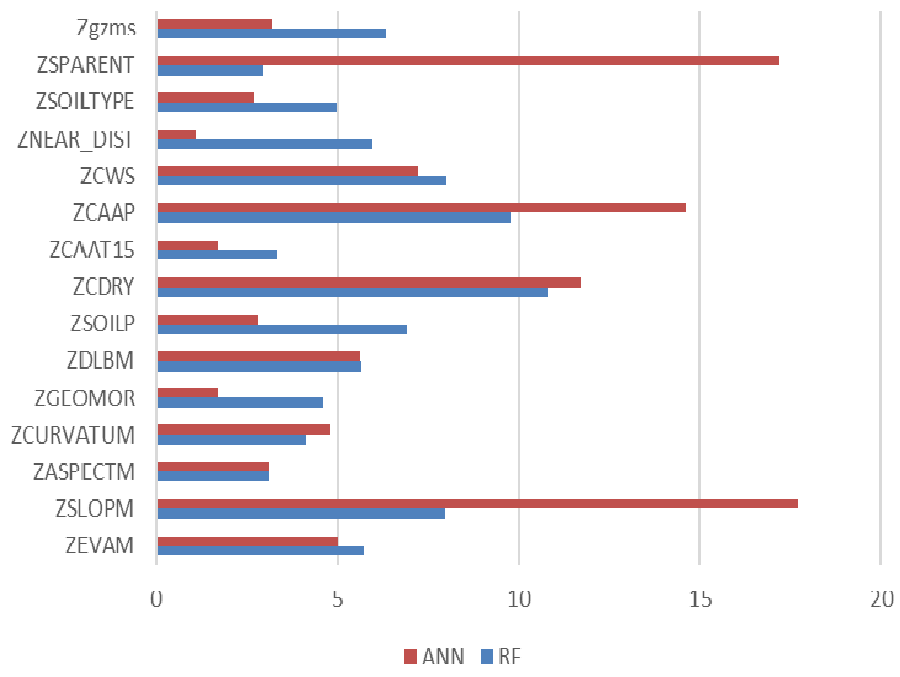
- Model Performance: Both Artificial Neural Networks (ANN) and Random Forest (RF) were tested. While ANN showed slightly better accuracy (lower error in specific samples), RF demonstrated higher stability.
- Feature Importance: The models revealed that soil parent material and climatic aridity are the dominant predictors for phosphorus levels in this arid region, likely due to their influence on both natural background levels and human irrigation behavior.
Deep Insight: Why This Matters
The true value of this work isn't just in the RMSE score; it’s in the elimination of salt-and-pepper noise. Conventional maps often show "noise" where individual pixels fluctuate wildly. In a geo-parcel map, the nutrient level is consistent across a single management unit, which is exactly how a variable-rate fertilizer spreader operates.
Limitations & Future Outlook
While the method is highly efficient, it relies heavily on the quality of the initial image segmentation. If the AI fails to "see" a boundary, the nutrient prediction for that entire area might be skewed. Future work will likely involve scaling this to more complex, heterogeneous environments and integrating time-series data to see how phosphorus levels fluctuate across growing seasons.
Conclusion
This research marks a significant step toward Object-Based Digital Soil Mapping. By treating the Earth as a collection of managed entities rather than a mathematical grid, we move closer to a future where AI-driven precision agriculture is both scientifically rigorous and practically seamless.