
Drone-Crowd Synergy: A New Paradigm for 3D Disaster Damage Mapping
A Method to Collect Multi-view Images of High Importance Using Disaster Map and Crowdsourcing
This paper presents a hybrid framework combining UAV-based 3D reconstruction with crowdsourcing to generate detailed disaster-damage maps. By integrating Structure from Motion (SfM) and Mask R-CNN, the system automates image collection and generates free-viewpoint videos for crowdworkers to assess building damage.
TL;DR
Assessing disaster damage quickly is a race against time. This paper introduces a system that marries UAV-driven 3D reconstruction with microtask crowdsourcing. By transforming 3D models into simple "free-viewpoint videos," the method allows remote workers to identify structural damage. Crucially, it features an iterative loop where ambiguous reports trigger targeted drone re-flights to capture high-importance visuals.
Background & Motivation: The "Blind Spot" of Satellites
When a disaster strikes, we often look to the sky. However, traditional satellite imagery and high-altitude aerial photography have a fundamental limitation: they only provide a top-down view (Nadir view). For a building that has collapsed sideways or sustained serious structural damage to its facade, these photos are practically useless.
The authors argue that we need "Multi-view" data. But collecting and analyzing multi-view data is expensive and labor-intensive. Their insight? Use drones for the collection and non-professional crowdworkers for the assessment, but bridge the gap between them with intelligent image processing middleware.
Methodology: Closing the Loop
The proposed workflow is a sophisticated pipeline consisting of four main stages:
1. Pre-Disaster Profiling
Before any disaster, drones map the area. Using Mask R-CNN, the system segments building footprints from aerial images and registers their GPS coordinates (WGS system). This creates a "baseline" 3D map of the urban environment.
2. Post-Disaster 3D Reconstruction
After a disaster, drones perform a comprehensive sweep. The middleware uses Structure from Motion (SfM) to stitch these images into a 3D model.
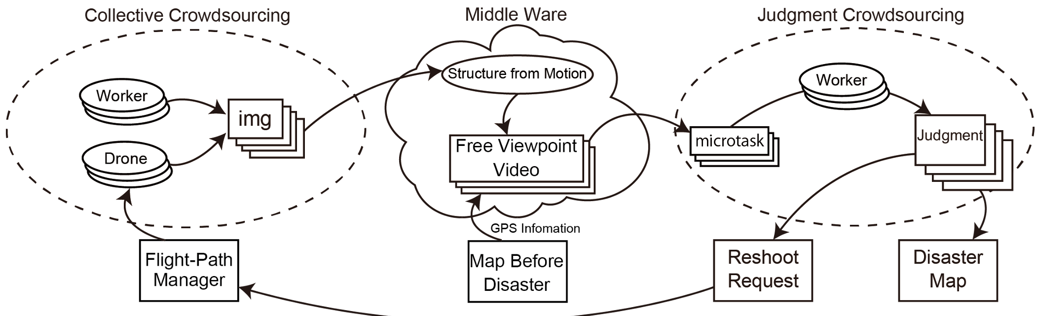 Fig 2: The iterative cycle of image collection, 3D generation, and crowd judgment.
3. Microtask Generation: The Free-Viewpoint Video
Navigating a 3D model (zooming, rotating, panning) is difficult for the average crowdworker. To solve this, the authors generate Free-Viewpoint Videos. These are pre-rendered video sequences orbiting specific buildings, allowing workers to "see" all sides of a structure simply by watching a clip.
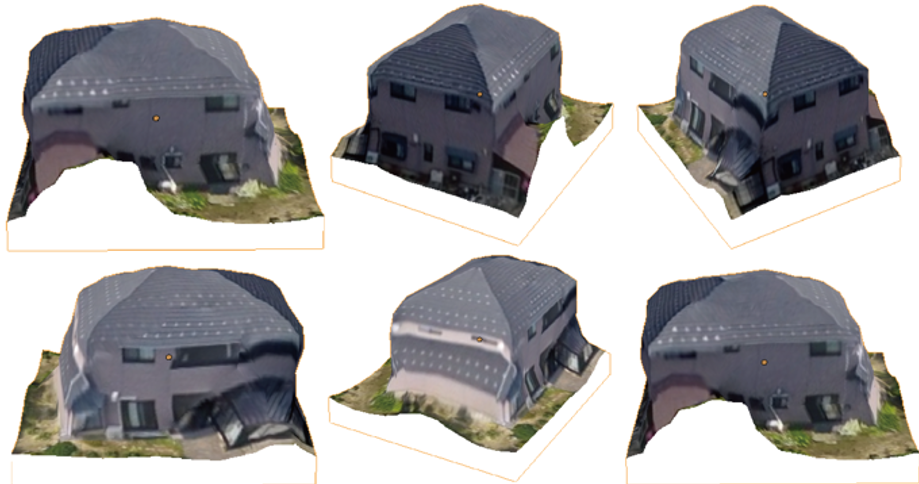 Fig 5: Transforming complex 3D data into intuitive video sequences for easier judgment.
4. Smart Re-shooting (Priority Feedback)
This is the core innovation. If crowdworkers label a building's state as "unknown" (often due to low-resolution or occlusion in the first 3D model), the system marks it as high priority. The drone's flight manager then calculates a new path to get closer, more detailed shots of that specific structure.
Experiments and Results
The authors demonstrated the feasibility of building segmentation (Fig 3) and 3D reconstruction (Fig 4).
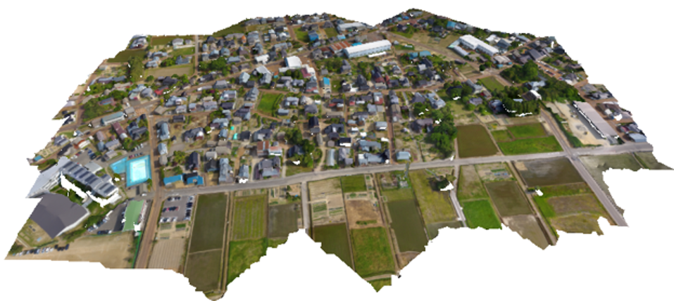 Fig 3 & 4: From 2D segmentation to 3D residential reconstruction.
The implementation of the microtask interface (Fig 6) showed that workers could provide "Degree of Damage" assessments (Totally destroyed, Half destroyed, No damage, Unknown) through a simple web-based questionnaire. This effectively converts qualitative human observation into quantitative map data.
Critical Insights & Future Outlook
While the paper establishes a solid framework, a few challenges remain:
- Latency: The "capture-process-re-shoot" loop needs to be extremely fast for real-world disaster response.
- Data Quality: SfM (Structure from Motion) can struggle with repetitive textures or highly decimated buildings.
- Scalability: Handling thousands of microtasks simultaneously requires robust crowdsourcing platforms like Crowd4U.
The Takeaway: This research moves us away from static disaster mapping toward Active Sensing. By treating crowdworkers not just as data annotators but as "navigators" for autonomous drones, we can focus limited hardware resources on the most critical and ambiguous disaster sites.