
Social Media as a Seismograph: Rapidly Mapping Earthquake Damage via Twitter
Early Tracking of People’s Reaction in Twitter for Fast Reporting of Damages in the Mercalli Scale
This paper introduces a real-time earthquake damage assessment system that infers Modified Mercalli Intensity (MMI) scales using Twitter data. The core method, "Reinforced Mercalli Support," aggregates lexical features at the county level to provide rapid intensity reports within 30 minutes of a seismic event.
TL;DR
Seismological centers often take hours to report the actual human impact (Mercalli Scale) of an earthquake. This paper proposes a system that uses Twitter as a distributed network of human sensors. By analyzing 12 simple lexical features and applying a "Reinforced Mercalli Support" algorithm, the system can estimate maximum earthquake intensity at a county level within 30 minutes of the first tremor.
The Gap Between Magnitude and Impact
When an earthquake strikes, we quickly learn its Magnitude (energy released). However, the Modified Mercalli Intensity (MMI)—which describes actual damage and human perception—is often more critical for emergency responders.
The problem? Mercalli reports are notoriously slow because they depend on professional observers reporting back to a central node. In regions with poor communication infrastructure or sparse sensor networks, this delay can be life-threatening. The research intuition here is simple: People tweet about what they feel. If we can mathematically "clean" this social signal, we can map damage in near real-time.
Methodology: From Tweets to Intensity
The authors don't just count tweets; they treat every county as a geographic "sensor." The process follows a rigorous three-step pipeline:
1. Social Tracking & Feature Extraction
The system collects tweets containing keywords like "quake" or "seismic" within a 30-minute window. Since only 0.26% of tweets are GPS-tagged, the authors use fuzzy string matching on user profile locations to map tweets to 345 Chilean counties. They extract 12 key features, including:
- Intensity Indicators: Fraction of tweets with exclamation marks, capital letters, or the word "earthquake."
- Contextual Data: Tweet length and "Tweets Norm" (tweets vs. population).
2. Identifying the Region of Interest (ROI)
An SVM classifier determines which counties actually "felt" the earthquake (Class 1) versus those just discussing it (Class 0). This filters out global chatter and focuses the model on the impact zone.
3. Reinforced Mercalli Support
This is the core mathematical contribution. To prevent "lone voices" or bots from skewing the data, the authors introduce a reinforcement formula:

Where is the raw intensity estimate and is the "social support" (observer density). This ensures that high intensity is only reported if a significant portion of the local Twitter population confirms it.

Performance & SOTA Comparison
The system was validated against 18 months of seismic data in Chile. The findings were striking:
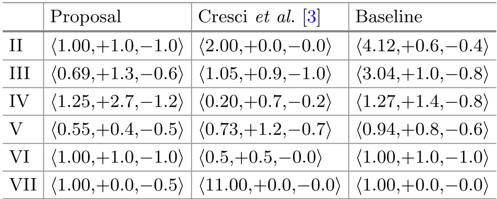
- High Accuracy for High Intensity: For earthquakes at Mercalli Scale V and above, the ROI detection was nearly perfect (error rate near 0).
- Efficiency: The model achieved an MAE of 0.55 to 1.0 across various scales using only 12 features, compared to 45 features in previous SOTA works.
- Maximum Intensity Detection: By looking for the "maximum adjusted Mercalli" within the ROI, the system effectively ignores the noisy low-quality data from the periphery of the event.
Critical Insight & Future Outlook
The genius of this approach lies in its independence from physical sensors. While Japan or California have dense seismograph networks, many earthquake-prone countries do not. This model proves that social media is a viable "virtual infrastructure."
Limitations: The reliance on fuzzy string matching for location is a bottleneck. As Twitter (now X) changes its API access and user behavior shifts, the system may need to incorporate more robust NLP (like NER) to extract location data from the tweet text itself.
Conclusion: This research moves us closer to a world where our social feeds aren't just for entertainment—they are a critical component of planetary-scale disaster management.