
EBSCAN: Rethinking Spatial Clustering through Trajectory Entanglement
EBSCAN: An Entanglement-based Algorithm for Discovering Dense Regions in Large Geo-social Data Streams with Noise
The paper introduces EBSCAN, a novel entanglement-based clustering algorithm designed to extract dense regions from large geo-social data streams. By shifting from point-density to trajectory-entanglement, it simplifies parameter tuning and outperforms the classic DBSCAN in speed and geographic awareness.
TL;DR
Researchers have developed EBSCAN, a clustering algorithm that uses the "entanglement" of user trajectories to find hotspots in geo-social data. By moving away from point-density metrics used by DBSCAN, this method is 10x faster, requires only one intuitive parameter, and respects physical geographical boundaries like walls or rivers.
Background: The Limits of Pure Density
For decades, DBSCAN has been the gold standard for discovering dense regions in spatial databases. It is prized for its ability to find non-linear shapes and handle noise. However, applying it to modern geo-social data (like Flickr photostreams or Twitter check-ins) reveals two critical flaws:
- Parameter Sensitivity: Finding the perfect balance between
Epsilon(distance) andMinPts(density threshold) is often a dark art. - Geographical Blindness: Traditional density methods only care about distance. If two groups of people are standing on opposite sides of a thick wall, a density-based algorithm might merge them into one cluster, ignoring the physical reality that the two groups cannot interact.
The "Entanglement" Insight
The authors of EBSCAN propose a shift in perspective. Instead of treating geo-tagged data as a "cloud of points," they treat it as a set of trajectories.
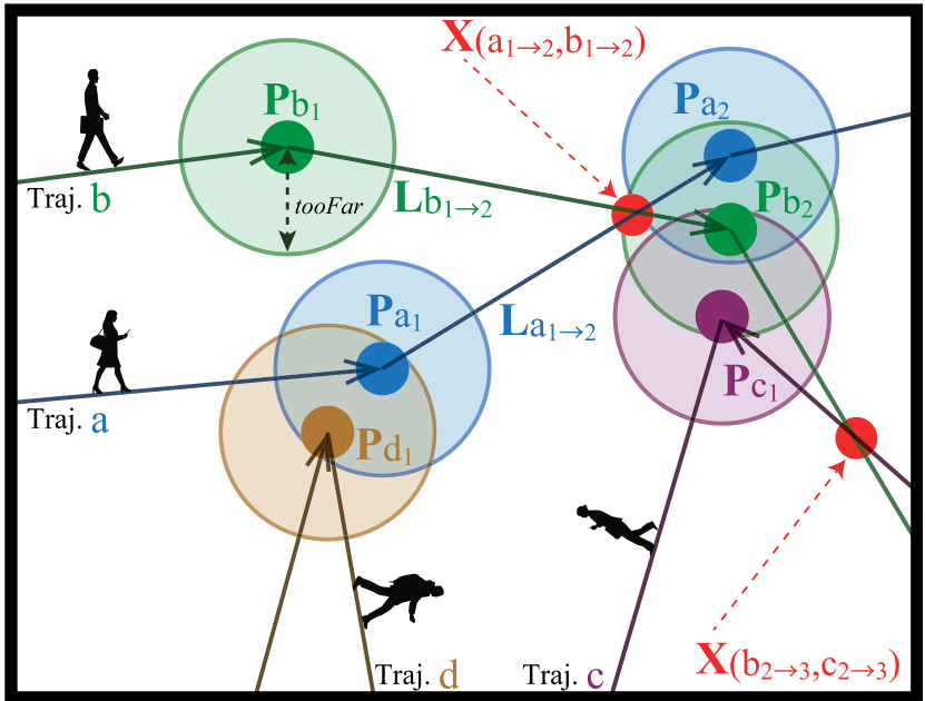
Even when users travel along similar paths, GPS error, rounding, and human behavior cause their recorded paths to crisscross or "entangle." EBSCAN posits that dense regions are areas where trajectories frequently intersect.
The Core Mechanism
- Intersection Detection: The algorithm first finds where different trajectory segments cross.
- Refined Grouping: It only groups points into a cluster if they are near an intersection and within a specific distance, defined by the parameter
tooFar.
Algorithm Deep-Dive
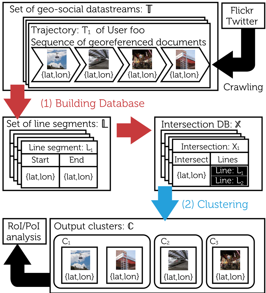
The workflow of EBSCAN consists of two primary stages:
1. Building the Intersection Database
The algorithm converts trajectories into line segments and uses an R-tree index to efficiently find all pairs of intersecting lines. This stage is computationally the most intensive but serves as a robust foundation for identifying regions of interest.
2. The Clustering Phase
For every intersection, the algorithm examines the four endpoints of the two intersecting lines. If the distance between these points is less than tooFar, they are merged into the same cluster.
Experimental Battle: EBSCAN vs. DBSCAN
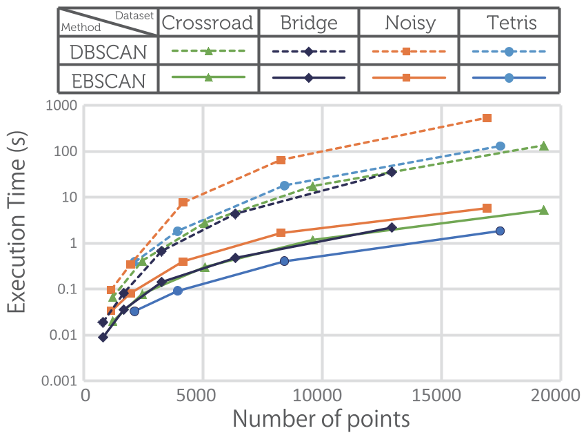
The researchers tested EBSCAN against a k-d tree optimized version of DBSCAN using both synthetic "toy" datasets and real Flickr data from Manhattan and Mt. Fuji.
Speed and Efficiency
EBSCAN achieved a massive speedup. In the clustering phase, it consistently performed over 10 times faster than DBSCAN. Even when including the time taken to build the intersection database, EBSCAN remained roughly 2x faster overall.
Handling Physical Barriers
In the "Bridge" test case (where two regions are connected by a narrow bridge but otherwise separated), DBSCAN often failed to separate the north and south sectors correctly. EBSCAN, by focusing on trajectory flow and intersection, maintained the logical separation of the regions.
Critical Insight & Future Outlook
The true value of EBSCAN lies in its simplicity for the end-user. By reducing the required parameters to a single metric (tooFar), it makes spatial clustering accessible for social scientists and marketers who may not have a background in hyperparameter tuning.
Limitations: Currently, the intersection-finding step using R-trees can still be a bottleneck for extremely large datasets. Future work should look into parallelizing this process or utilizing sweep-line algorithms like Bentley-Ottmann more effectively to handle floating-point errors.
Conclusion
EBSCAN represents a significant step forward in geo-social analysis. By recognizing that human movement (trajectories) contains more information than simple static locations, it provides a faster, more accurate, and more intuitive tool for mapping the pulse of our cities.