
Hybrid Intelligence for Urban Ecology: Leveraging Random Forest for Beijing's EEQ Monitoring
Eco-Environmental Quality Monitoring in Beijing, China, Using an RSEI-Based Approach Combined With Random Forest Algorithms
This study presents an improved framework for monitoring Ecological Environmental Quality (EEQ) in Beijing by combining the Remote Sensing Based Ecological Index (RSEI) with Random Forest machine learning. By integrating four satellite-derived indicators (greenness, wetness, dryness, and heat) via PCA and ensemble learning, the authors achieved a more stable and comparable spatio-temporal analysis of urban ecology between 2014 and 2020.
TL;DR
Researchers have developed a more robust way to track the "health" of megacities. By combining the Remote Sensing Based Ecological Index (RSEI) with Random Forest algorithms, this study overcomes the classic problem of inconsistent year-over-year comparisons. Applying this to Beijing (2014–2020), they found that while the city is getting drier and hotter, a massive 26% boost in greenness has successfully tipped the ecological scales toward improvement.
The "Moving Target" Problem in Ecological Monitoring
How do you objectively measure the environmental quality of a city? For years, the gold standard has been the RSEI, which bundles four satellite-derived metrics:
- Greenness (Vegetation health)
- Wetness (Soil/surface moisture)
- Heat (Land surface temperature)
- Dryness (Built-up area and bare soil)
The traditional way to mix these is via Principal Component Analysis (PCA). PCA is great because it assigns weights automatically without "expert bias." However, there's a catch: the weights change every time you run it on a new year. If the weight of "Heat" is 0.4 in 2014 and 0.2 in 2020, you can't compare the scores. It’s like trying to track a student's progress when the grading rubric changes every semester.
Methodology: Stabilizing the Rubric with Random Forest
The authors proposed a clever fix. Instead of running two separate PCAs, they used the 2020 data to define the "Ecological Standard" using PCA, then trained a Random Forest (RF) model to learn that specific relationship.
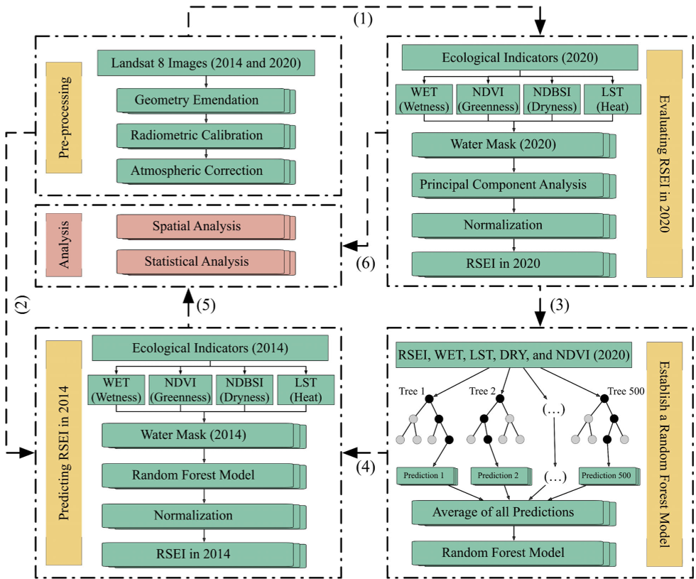 Figure 1: The improved framework using PCA to initialize and Random Forest to standardize the monitoring process.
By using the RF model as a fixed "predictor" for 2014, the researchers ensured that any change in the resulting RSEI score was due to actual environmental changes on the ground, not a shift in the mathematical model.
Key Insights: Beijing's Green Shield
The results from 2014 to 2020 offer a fascinating look at urban evolution:
- The Positive: Greenness (NDVI) exploded by 26.09%, thanks to initiatives like the "green-wedge" policy and increased urban landscaping.
- The Negative: Dryness (NDDBI) and Heat (LST) both increased as the city's concrete footprint expanded.
- The Net Result: The RSEI moved from 0.31 to 0.33. While this still sits in the "Poor" category, the trend is upward.
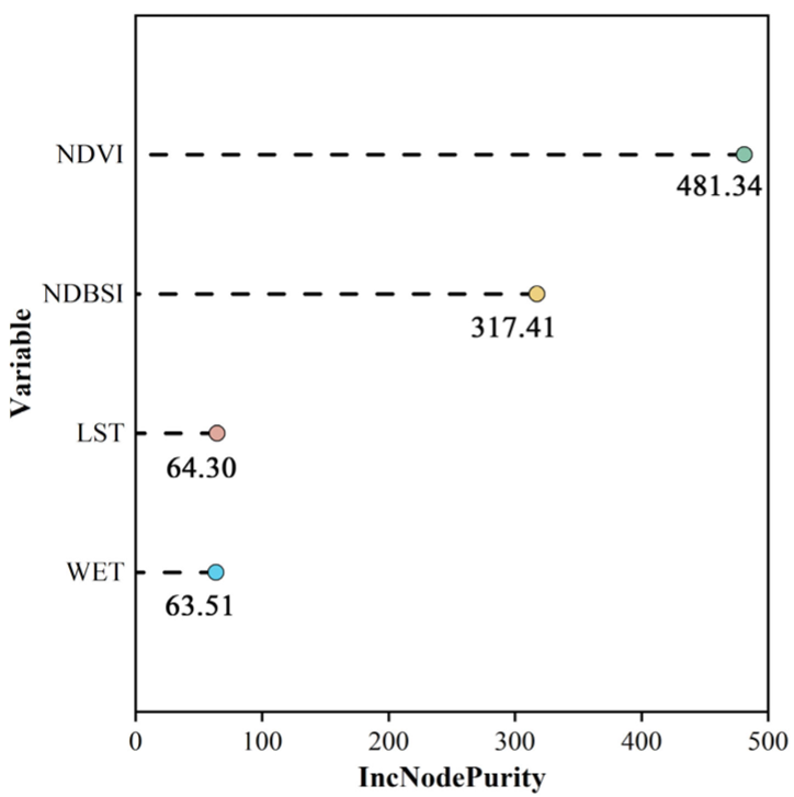 Figure 2: Importance ranking showing that Greenness (NDVI) and Dryness (NDBSI) are the dominant drivers of Beijing’s environmental quality.
The Random Forest model identified Greenness as the most influential factor. This proves that for megacities, "planting your way out of trouble" is a mathematically sound strategy to counteract the Heat Island effect and soil desiccation.
Critical Analysis & Future Outlook
The beauty of this approach is its transferability. Because it relies on public Landsat 8 data, this "RSEI + RF" framework can be deployed to any city globally.
However, some challenges remain. The thermal bands used for the "Heat" index have a much lower resolution (100m) than the optical bands (30m). This creates a "resolution bottleneck." Additionally, while the model tells us what changed, the underlying mechanisms—such as how specific tree species affect moisture levels versus temperature—require deeper ecological modeling.
Takeaway: As urban areas face the dual threats of climate change and expansion, shifting from static indices to machine-learning-driven dynamic monitoring is essential for sustainable urban planning.