
Efficient Spatial Mining: Bridging SNS Big Data and Geographic Geometry
5774_An Efficient Geographical Place Mining Strategy for Social Networking Services.
This paper introduces an "Efficient Geographical Place Mining Strategy" designed to retrieve Social Networking Service (SNS) data points within specific arbitrary boundaries. The core method combines Minimum Bounding Rectangle (MBR) evaluation, subarea partitioning, and an optimized ray-casting algorithm to minimize database access overhead and computational complexity.
TL;DR
The explosion of Social Networking Services (SNS) has created a goldmine of geographical data, but extracting points within specific, irregular boundaries remains a technical bottleneck. This paper proposes a strategy that segments large geographical areas into optimized sub-grids to balance database access efficiency with geometric accuracy, reducing computational overhead by several orders of magnitude compared to naive approaches.
Context: The Spatial Data Dilemma
In the era of Big Data, platforms like Facebook, Instagram, and Foursquare generate millions of "check-in" coordinates. While a standard SQL query can easily find points in a simple rectangle, real-world areas (like a specific neighborhood or a folk-ritual boundary) are irregular polygons.
The naive approach—checking every point in the database against the polygon boundary—results in a complexity of , where is the total number of points in the SNS database. When is in the billions, this is practically impossible.
The Proposed Strategy: Divide and Conquer
The authors suggest that the secret to efficiency isn't just a faster geometric algorithm, but a smarter way to interface with the database. They propose a four-step pipeline:
- Border Evaluating: Calculate the Minimum Bounding Rectangle (MBR) to quickly discard any points that are clearly outside the target zone.
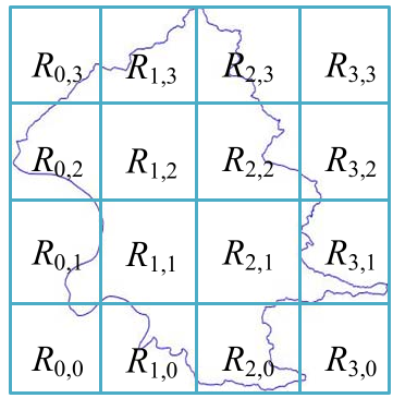
- Subareas Partitioning: Instead of one massive query or a million tiny queries, the area is divided into a grid. The value of is dynamically calculated to match the "Optimal Batch Size" () of the database system.
- Places Retrieving: SQL queries fetch points for each subarea.
- Places Positioning: A pinpoint "Inside Algorithm" (Ray Casting) is applied only to the points within the sub-grids to confirm their exact presence within the irregular polygon.
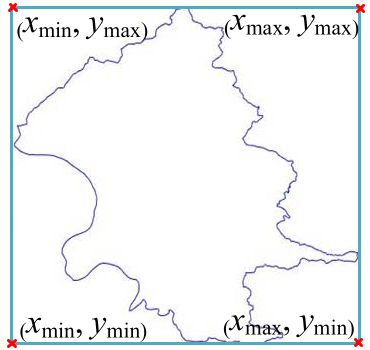 Figure: The four-step process from border evaluation to final positioning.
Methodology: The "Inside" Algorithm
At the heart of Step 4 is the Inside(A, p) algorithm. It uses a mathematical concept where a ray is projected from a point. If the ray intersects the polygon edges an odd number of times, the point is inside. If even, it’s outside.
```c
Algorithm Inside (A, p) {
  count = 0;
  for (i = 0; i < |A|-1; i++) {
    if (IE(p, E(ai, ai+1)) == 1) count++;
  }
  return (count % 2); // Odd = Inside, Even = Outside
}
```
Experimental Performance
The researchers tested their strategy against fixed-access methods (varying the number of database calls, ). The results demonstrate a clear "Goldilocks Zone" for database access.
If is too small (e.g., ), the system retrieves too many irrelevant points, overwhelming the local processor. If is too large (e.g., ), the database overhead (latency) kills performance. The Proposed Strategy dynamically adjusts to find the optimal efficiency.
| Data Points () | Naive () | Fixed () | Proposed Strategy |
|---|---|---|---|
| 10,000 | 25,937 | 46,476 | 11,118 |
| 80,000 | 1.64E+08 | 90,130 | 90,130 |
| 320,000 | 5.63E+18 | 515,439 | 355,648 |
The data shows that as the number of places grows, the proposed strategy scales linearly, whereas naive methods scale exponentially.
Final Insights
This research highlights a crucial aspect of modern AI and Data Engineering: Theoretical complexity is not the only bottleneck. The physical reality of hardware I/O and database access patterns often dictates the true performance of an algorithm. By tailoring the subarea grid to the database's "sweet spot" for batch retrieval, the authors provide a practical framework for real-world GIS (Geographic Information System) applications.
Future Outlook: The next frontier involves handling "Hot-Spots"—areas like city centers where point density is significantly higher than rural areas, requiring non-uniform grid partitioning (like Octrees).