
Smartphone Crowdsourcing: A High-Precision Approach to Multi-Factor Road Surface Estimation
Estimating Road Surface Condition Using Crowdsourcing
The paper introduces a crowdsourcing-based framework for estimating road surface conditions using smartphone motion sensors (accelerometers and gyroscopes). By combining Road Surface Type (RST) and Road Surface Shape (RSS) into a unified classification target, the authors achieve up to 91% accuracy using a Random Forest classifier optimized via Sequential Forward Floating Search (SFFS).
TL;DR
Researchers have developed a method to detect both Road Surface Type (RST) (e.g., ice, snow, asphalt) and Road Surface Shape (RSS) (e.g., potholes, bumps) simultaneously using nothing but a standard smartphone. By leveraging a crowdsourcing app and the Sequential Forward Floating Search (SFFS) algorithm for feature selection, they achieved a classification accuracy of 91%, specifically bridging the gap between low-cost sensing and high-stakes winter driving safety.
Problem & Motivation: The Winter Driving Blindspot
In snowy regions like Japan, road conditions shift rapidly between transitions of packed snow, sherbet-like slush, and lethal "black ice." Most existing solutions are binary: they either use cameras to look at the "substance" on the road or use accelerometers to detect "bumps."
The authors identified a major gap: No single low-cost study supports both RST and RSS. Furthermore, camera-based systems (computer vision) fail in low light or heavy snow, while traditional vibration-based sensors often require expensive, fixed mounting that isn't scalable for city-wide monitoring.
Methodology: Beyond Vertical Vibration
The core insight of this paper is that road conditions affect more than just vertical "bounce." A car slipping on ice or hitting a pothole generates complex patterns across all three axes of motion.
1. Defining the Target
Instead of simple labels, the authors created a Cartesian product of:
- Types (RST): Paved, Sherbet, Compacted Snow, Frozen.
- Shapes (RSS): Smooth, Bumpy, Potholes, Mixed.
2. Feature Extraction and Selection
The team extracted 67 features from the accelerometer and gyroscope, including mean, standard deviation, and energy. To filter out engine vibrations, they divided the frequency domain into five intervals, focusing on low-frequency components for driver behavior and high-frequency for road-vehicle interaction.
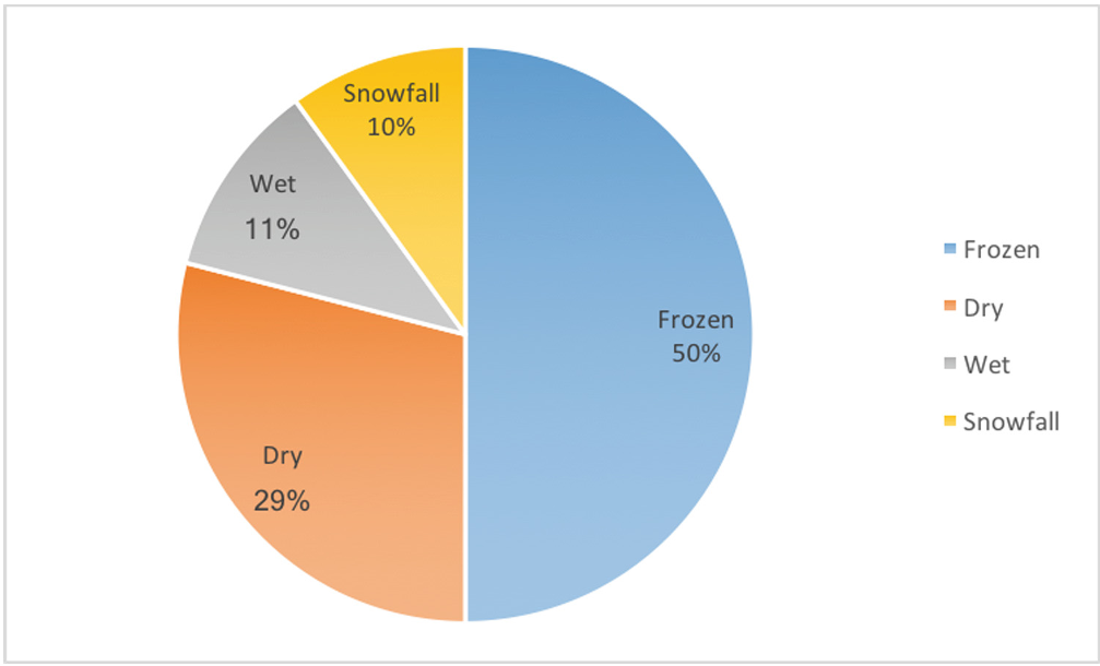 Figure: The winter traffic accident rates justifying the need for specialized frozen-road detection.
The study compared three mathematical approaches to find the "Goldilocks" feature set:
- PCA: Good for reduction but lacks interpretability.
- Relief-F: A filter-based approach.
- SFFS (Sequential Forward Floating Search): A wrapper-based method that iteratively adds and removes features to optimize accuracy. SFFS proved superior, pinpointing that the correlation between vertical and lateral acceleration is a prime indicator of road grip.
Experiments & Results: The Speed Sweet Spot
The researchers tested their "Drive ATC" (Around-The-Corner) application in real-world conditions. A critical finding was that vehicle speed significantly alters the signal.
- 50 km/h - 80 km/h: The "Sweet Spot" where the system peaked at 91% accuracy. At these speeds, the interaction between the tire and the road surface is consistent enough to produce distinct vibration signatures.
- Low Speeds (<20 km/h): Accuracy was lower because road anomalies (like a single pothole) produce signals that are harder to distinguish from stop-and-go driving noise.
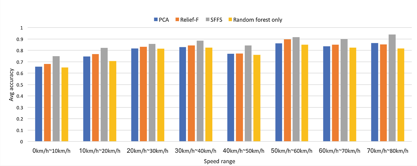 Figure: SFFS (green) consistently outperforms PCA and Relief-F across almost all speed ranges.
Critical Insight & Conclusion
Takeaway
The success of the SFFS + Random Forest combo suggests that "feature engineering" still holds immense value even in the age of deep learning. By understanding the physics of vehicle motion—specifically how horizontal slippage correlates with vertical impact—the authors turned a noisy smartphone sensor into a surgical tool for infrastructure management.
Limitations & Future Work
The primary bottleneck is vehicle heterogeneity. A heavy SUV with soft suspension will "feel" the road differently than a compact car with stiff tires. The authors acknowledge that future iterations must normalize data across different vehicle types and individual driving styles to make this a truly universal crowdsourced solution.
Ultimately, this work paves the way for a real-time "Road Weather Map," where data from thousands of commuter smartphones can alert drivers to hidden ice patches before they even turn the corner.