
Refined Path Loss Prediction: Solving the ITU-R P.1546 Gap in Rural Australia
Evaluation of the Propagation Model Recommendation ITU-R P.1546 for Mobile Services in Rural Australia
This paper evaluates the ITU-R P.1546 propagation recommendation (versions 0, 1, and 2) for short-range mobile services in rural Australia at 881.52 MHz. By comparing model predictions against field measurements from a commercial CDMA network, the authors propose "Model A," which integrates a reciprocal effective antenna height definition and vegetation-specific attenuation.
TL;DR
Accurate radio coverage prediction is the backbone of mobile network planning. This study reveals that the international standard Recommendation ITU-R P.1546-2 fails significantly in rural Australian environments, underestimating field strength by more than 10 dB. The authors introduce Model A, a localized adaptation that fixes stability issues with antenna heights and incorporates vegetation density data, resulting in a more robust and accurate prediction tool for rural CDMA/LTE/5G-low-band deployments.
Contextualizing the Problem
While urban environments attract the bulk of propagation research, rural areas present unique challenges: irregular terrain, varying vegetation types, and long-range macrocells. Existing "gold standards" like the Okumura-Hata model are frequently too optimistic, leading to coverage gaps. Conversely, the ITU-R P.1546 series—intended to be a universal successor—has introduced complexity that, in certain versions, leads to massive errors. Specifically, the definitions of Effective Antenna Height () can turn negative on slopes, causing the mathematical model to "explode" and predict physically impossible path losses (>50 dB error).
The Core Insight: Why P.1546-2 Fails
The paper highlights a critical change in version P.1546-2: the Terrain Clearance Angle (TCA) correction.
- The Flaw: P.1546-2 excludes TCA corrections for angles below 0.55°, making it overly pessimistic for flat rural terrain where Line-of-Sight (LOS) or near-LOS conditions prevail.
- The Result: It treats these areas as more obstructed than they are, leading to an average error of 11.11 dB.
Methodology: Engineering a Better Model (Model A)
1. Reciprocal Antenna Height ()
Traditional definitions are non-reciprocal, meaning the prediction changes if you swap the transmitter and receiver. The authors propose an alternative based on the average difference of terrain height relative to a line connecting the ground levels of both points.
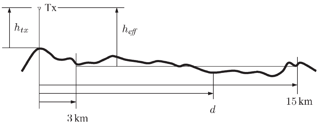 Fig 1: Standard effective height definition which the authors found unstable at short distances.
2. Vegetation-Specific Attenuation
The authors didn't just use clutter categories; they utilized 25m grid Perennial Crown Density data. They mapped 10 distinct vegetation types into two categories:
- Woodland: Attenuation =
- Shrubland: Attenuation =
Experimental Validation
Using a CDMA pilot scanner across 400km of Western Australia, the authors compared the different P.1546 versions against their proposed Model A.
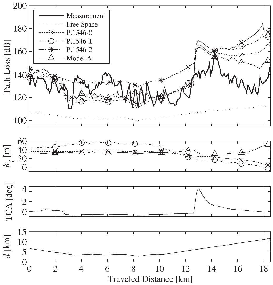 Fig 2: A measurement track showing the "overshoot" of previous models (black/gray lines) vs the more accurate Model A (dashed line).
Quantitative Results
| Model | Mean Error () | Std Dev () | Hit Rate (AHRE) |
|---|---|---|---|
| P.1546-2 | 11.11 dB | 8.71 dB | 23.07% |
| Okumura-Hata | -8.65 dB | 8.83 dB | 18.39% |
| Model A (Proposed) | 1.95 dB | 8.19 dB | 14.76% |
Critical Analysis & Conclusion
Model A’s success stems from fixing the "negative " instability and re-introducing TCA logic that respects LOS conditions in flatlands. However, the study identifies a remaining challenge: Distance-Dependent Corrections. Both TCA and Mobile Antenna Height corrections appear to behave differently within 10 km of the base station than they do at 50 km.
Takeaway for Engineers: When using ITU-R P.1546 for rural planning, ensure your implementation handles negative effective heights gracefully and consider local vegetation density rather than just generic "clutter" categories. The "latest" version (P.1546-2 in this context) isn't always the best for every geography.