
Bridging the Digital Gap: A Framework for Expressive and Location-Aware 3D Social Worlds
A Framework for the Development of Online, Location-Specific, Expressive 3D Social Worlds
This paper presents a multi-modal framework for 3D social virtual worlds, integrating the "Emotion Analyser" for text-to-affect mapping and "Virtual City Maker" for geo-accurate urban modeling. The system achieves expressive communication by automating the generation of location-specific environments and synchronizing facial animations with emotional cues extracted from chat messages.
TL;DR
Digital social interaction often feels "flat" because it lacks facial cues and a sense of physical place. This paper introduces an integrated framework that uses Emotion Analyser to turn text into 3D facial expressions and Virtual City Maker to build accurate, geo-referenced 3D cities, creating a more "human" online communication experience.
The Motivation: Why Virtual Worlds Feel Cold
Despite the rise of social platforms, digital communication remains largely decoupled from human biological expression. The authors identify two major missing components:
- Visual Cues: Text cannot convey the nuance of a smile or the intensity of anger.
- Geographical Context: Virtual spaces are often generic, lacking the "groundedness" of real-world locations.
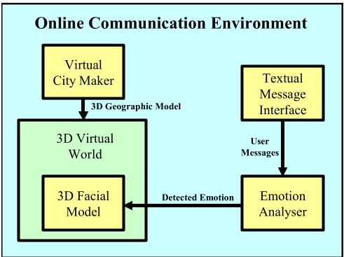
The core insight is to create a "pipeline of expression" where the system understands both what the user says (emotionally) and where they are (geographically).
Methodology: From Text Parsing to Urban Grids
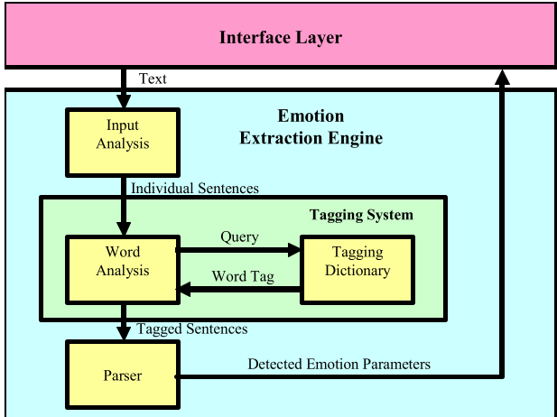
1. Emotion Analyser: The Linguistic Engine
The system doesn't just look for "happy" or "sad." It uses a sophisticated rule-based parser that handles:
- Intensity: Differentiating between various levels of the same emotion.
- Negation & Conditions: Recognizing that "I am not happy" is different from "I am happy," and managing conditional statements like "I'm happy when..."
- Emotional Momentum: It applies a weighting system where the most recent sentence carries more influence on the avatar's current mood.
2. Virtual City Maker: The Spatial Engine
Rather than modeling every building by hand, the authors use a Hybrid Data Approach. They combine aerial photos (for accuracy) with 2D ground maps and GIS vector data (.shp files).
- Automatic Mode: Uses GIS metadata (age, height, land use) to extrude 2D footprints into 3D buildings.
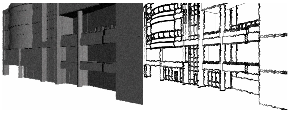
- City Shader: A non-photorealistic rendering (NPR) engine that allows the world to look like a watercolor painting or a comic book, which can often be more expressive and less computationally taxing than photorealism.
Experiments and Visual Results
The researchers demonstrated that by assigning numerical Material IDs to floors and roofs automatically, they could drastically speed up the texturing process—a known bottleneck in 3D modeling.
The City Shader results (Figure 2) show that abstract styles like hatching and line rendering remain legible and "expressive," even when real-time performance constraints are tight. By moving away from Gouraud shading to a boundary-based cel-shading algorithm, they achieved a visual style that prioritizes "cognition and cartography" over raw pixels.
Critical Analysis & Conclusion
Takeaway
The true value of this work lies in its holistic framework. It recognizes that social presence isn't just about high-resolution avatars; it’s about the synchronization of emotion, language, and geography.
Limitations & Future Work
- Rule-Based Limits: While the 17,000-word dictionary is extensive, it lacks the flexibility of modern Large Language Models (LLMs) to understand sarcasm or complex cultural slang.
- Manual Intervention: The semi-automatic urban modeling still requires human oversight for high-detail areas.
Looking ahead, the integration of this framework with automated lip-syncing (using MaxScript) suggests a future where virtual avatars act as highly expressive, autonomous extensions of our digital selves, grounded in the real-world maps we navigate every day.