
Automated Aerial Intelligence: Revolutionizing Agricultural Management in the Kingdom of Tonga
14857_A framework for the management of agricultural resources with automated aerial imagery detection.
The paper introduces a comprehensive framework for agricultural resource management using UAV high-resolution aerial imagery (0.04m) and Deep Learning. It employs a modified YOLO model for the localization and classification of four tropical fruit tree species and a modified SegNet for road segmentation, achieving 97.5% classification accuracy and 80% localization accuracy.
TL;DR
Researchers from ETH Zürich have developed a robust pipeline that combines UAV-acquired high-resolution imagery with Convolutional Neural Networks (CNNs) to automate the monitoring of tropical fruit trees and road networks. By adapting the YOLO and SegNet architectures, the framework provides rapid data for food security planning, disaster assessment, and harvesting optimization in Tonga, achieving a classification accuracy of nearly 98%.
Problem & Motivation: The Resilience Gap
For many island nations like Tonga, agriculture is the backbone of the economy, yet it remains vulnerable to climate-induced disasters such as cyclones. Traditional monitoring is expensive and fails to provide the "rapid response" required after a disaster.
The technical challenge lies in the complexity of rural imagery. Unlike neat industrial monocultures, tropical agriculture often features overlapping canopies, varying tree ages, and irregular road infrastructures that traditional "rule-based" computer vision (e.g., shadow-following or brightness thresholding) cannot handle effectively.
Methodology: The Dual-CNN Pipeline
The authors proposed a specialized workflow that splits the aerial data into two distinct processing streams:
1. Object Localization & Classification (Modified YOLO)
The system identifies four key species: Coconut, Banana, Mango, and Papaya.
- Circular Adaptation: Since trees are circular from a top-down view, the standard YOLO bounding box (width/height) was simplified to a single radius (r) parameter.
- Data Augmentation: To overcome the lack of labeled aerial data, they employed random flipping and rotations, generating over 27,000 training patches.
- Density Mapping: Beyond simple counting, the model uses a Gaussian Kernel to generate heatmaps (Density Maps), visualizing the concentration of resources across the landscape.
 Figure 1: Modified YOLO architecture adapted for tree localization.
2. Infrastructure Extraction & Path Optimization
Using a modified SegNet, the authors segment the road network. However, because rural roads are often obscured by tree crowns, the raw segmentation is often "disconnected."
- Pathfinding Insight: Instead of seeking perfect pixel geometry, the authors converted street pixels into nodes of a Delaunay triangulation.
- Genetic Algorithm (GA): By overlapping the tree density maps with this road graph, a GA is used to solve multi-objective queries, such as "Find the path that yields the most crops within a 10-minute travel window."
Experiments & Results
The model was validated on an 80 dataset from Tonga with a spatial resolution of 4-8 cm.
- Localization Precision: The average error between the predicted tree center and the ground truth was less than 1 meter (8.86 pixels).
- Classification Depth: While Coconuts represented 78% of the data, the model maintained high precision across rarer species like Papaya.
- SOTA Comparison: In a comparison with seven recent studies (including Chen et al. and Luus et al.), this model’s F1-Score of 0.89 outperformed several existing hybrid and CNN-based methods.
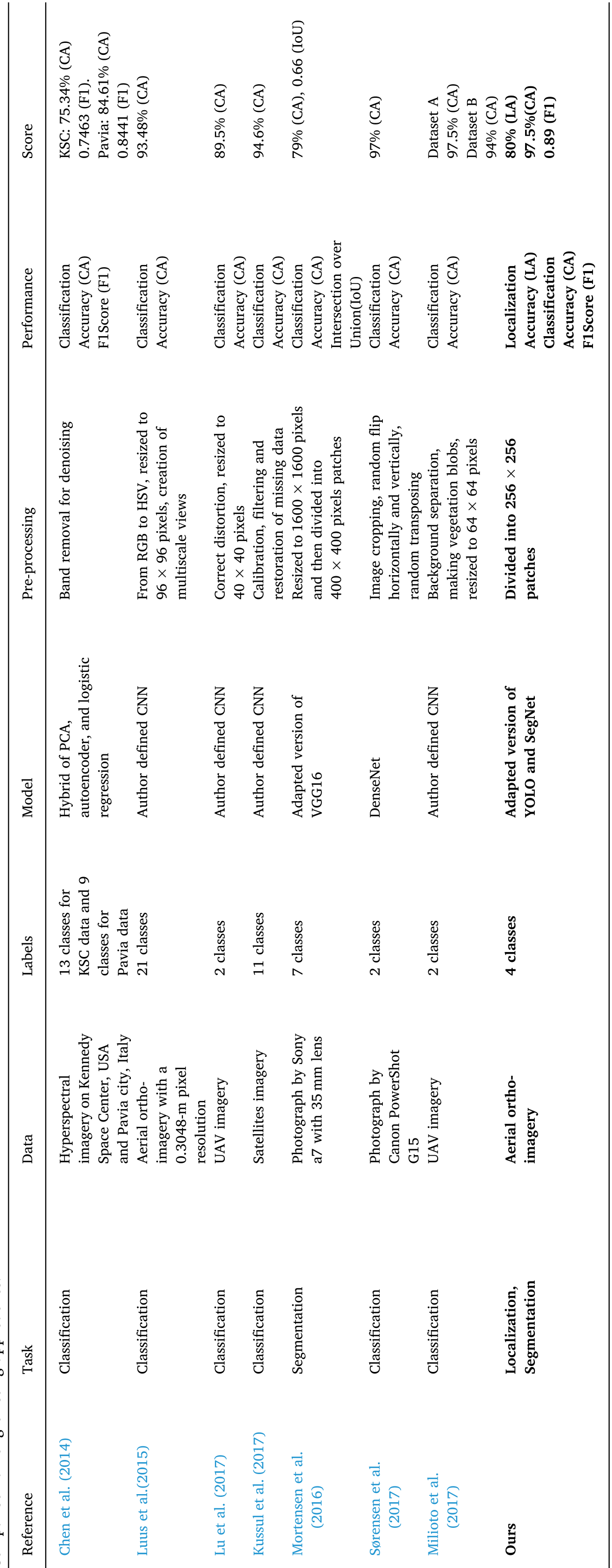 Table 1: Benchmarking the proposed model against existing remote sensing literature.
Critical Analysis & Conclusion
Takeaway
The real value of this work is not just in "counting trees," but in the integration of detection with logistics. By combining probability-based density maps with a Genetic Algorithm for pathfinding, the authors moved from "observation" to "actionable management."
Limitations & Future Work
- Context Transfer: The street detection model (trained on Potsdam, Germany) struggled with the rural Tongan landscape. Future iterations would benefit from Domain Adaptation or transfer learning using rural-specific road datasets.
- Real-time Potential: While the current pipeline is optimized for post-processing, moving this to edge-computing devices directly on the UAV could enable real-time disaster aerial surveys.
This framework represents a significant step toward "Precision Forestry" in developing regions, providing a blueprint for how AI can safeguard food security in the face of environmental volatility.