
Monitoring Wildfire Fuel Breaks: A Phenology-Robust Approach using Sentinel-2 and GEDI
Fuel Break Vegetation Monitoring with Sentinel-2 NDVI Robust to Phenology and Environmental Conditions
This paper presents a robust methodology for monitoring Fuel Break (FB) vegetation status in Portugal using Sentinel-2 NDVI time series. By employing an inter-annual comparison and a dynamic reference system, the approach accurately estimates fuel load recovery and validates results against GEDI LiDAR vegetation height data.
TL;DR
Researchers have developed a new way to track how fast flammable vegetation grows back in "Fuel Breaks" (FBs)—the critical clearings that act as firewalls during wildfires. By using Sentinel-2 NDVI data smoothed with a 3-month moving average and validated by NASA's GEDI space-laser, the system provides a specialized "growth percentage" that tells forest managers exactly when it’s time to send in the clearing crews, regardless of the season or local plant types.
Background: The Infrastructure of Firefighting
In fire-prone regions like Portugal, Fuel Breaks are human-made strips of land where vegetation is strictly managed. For these to work, the "fuel load" (biomass) must stay below a specific threshold. However, manually checking thousands of kilometers of FBs is impossible. While satellites like Sentinel-2 provide frequent updates, their data is often "noisy" due to seasonal changes (leaves turning green in spring vs. drying in summer), making it hard to distinguish between healthy growth and a dangerous accumulation of fire fuel.
The Core Challenge: Phenology and Heterogeneity
Traditional remote sensing often fails because:
- Phenological Noise: A high NDVI (greenness) value in May might just be seasonal peak, not necessarily a dangerous fuel load.
- Spacial Diversity: A pine forest in the North grows differently than a shrubland in the South; a "one-size-fits-all" threshold leads to false alarms.
Methodology: The "Inter-Annual" Solution
The authors propose a logic that moves away from absolute values and toward relative growth.
1. Dynamic Reference Scaling
Instead of using a global NDVI target, the method establishes a Reference Min (post-treatment) and Reference Max (pre-treatment) for each specific break. This accounts for local environmental conditions.
2. The Growth Formula
To cancel out seasonal effects, the system compares the current month's NDVI to the same month from the previous year.

- : This difference essentially asks: "Is it greener this June than it was last June?"
- Scaling: This difference is then normalized against the local reference range, ensuring the output is a comparable "State of Fuel Load" percentage.
Verification with Space-Lasers (GEDI)
To prove that NDVI (greenness) actually maps to physical fuel, the authors used GEDI (Global Ecosystem Dynamics Investigation), a LiDAR instrument on the ISS that measures vegetation height.
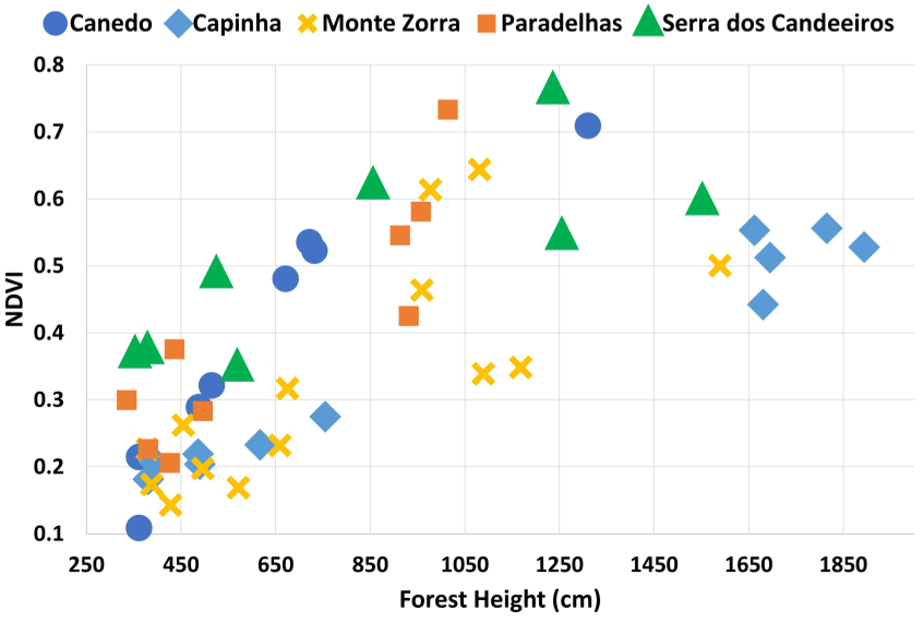
The results were striking: when analyzed per-Fuel Break, the correlation (R²) reached as high as 0.97. This confirms that for specific local sites, the satellite index is a highly reliable proxy for actual physical height/biomass.
Key Results
The system was tested on several Portuguese sites (e.g., Fundão, Marisol).
- Predictive Power: It successfully tracked the 2-3 year recovery period (24-36 months) typical for these regions.
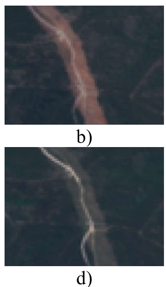
- Anomaly Detection: In Serra dos Candeeiros, the system correctly detected a drop in the index after a partial treatment was executed, proving it can be used for compliance monitoring (checking if the work was actually done).
Critical Insight & Future Outlook
This work demonstrates that context is everything in environmental AI. By anchoring satellite data in "Pre" and "Post" treatment references, the model becomes robust to the diverse flora of the Mediterranean.
Limitations:
- The NDVI can "saturate" (stop increasing) even if biomass continues to grow in very dense areas.
- The first year after treatment remains tricky because there is no "previous year" of treated data to compare against.
Future Work: The team aims to incorporate other spectral indices (like EVI or NDRE) that may handle high-biomass saturation better than NDVI, potentially improving accuracy for dense eucalyptus forests.
Conclusion
This methodology provides a scalable, automated "Dashboard for Fire Safety," allowing government agencies to move from reactive firefighting to proactive, data-driven forest management.