
CICE: Gamifying the Urban Fabric to Enrich Cultural Heritage
Gamifying cultural experiences across the urban environment
This paper introduces a microservices-based system architecture designed to gamify urban cultural experiences by computing personalized routes. It integrates official institutional data with unofficial crowdsourced content, validated through the prototype mobile application "CICE," which achieved high user engagement in real-world smart city scenarios.
TL;DR
Researchers from the University of Bologna have developed a microservices-based framework that turns city exploration into a game. By combining personalized pathfinding with gamification, their prototype app CICE encourages tourists to act as "prosumers"—sharing photos and accessibility data to enrich official museum and municipality records while following a custom-tailored route.
The Motivating Gap: From Consumers to Prosumers
Standard navigation tools like Google Maps are excellent at finding the fastest route but fail to capture the "soul" of a city or the specific cultural leanings of a traveler. Moreover, Galleries, Libraries, Archives, and Museums (GLAM) often struggle to keep their data sets updated with real-time conditions (e.g., temporary closures or accessibility details).
The authors identify a critical missing link: Engagement. They argue that by treating the city as a living laboratory and the user as a data producer, we can create a self-sustaining ecosystem of cultural knowledge. The challenge lies in how to orchestrate heterogeneous data sources while keeping the user motivated and their personal data private.
Methodology: Orchestrating the Smart Experience
The backbone of this research is a modular microservices architecture. This design choice ensures that the system is "data-agnostic," meaning it can easily swap or add new data sources (like Flickr or OpenStreetMap) without rebuilding the core logic.
The Preferences Layer and MyData
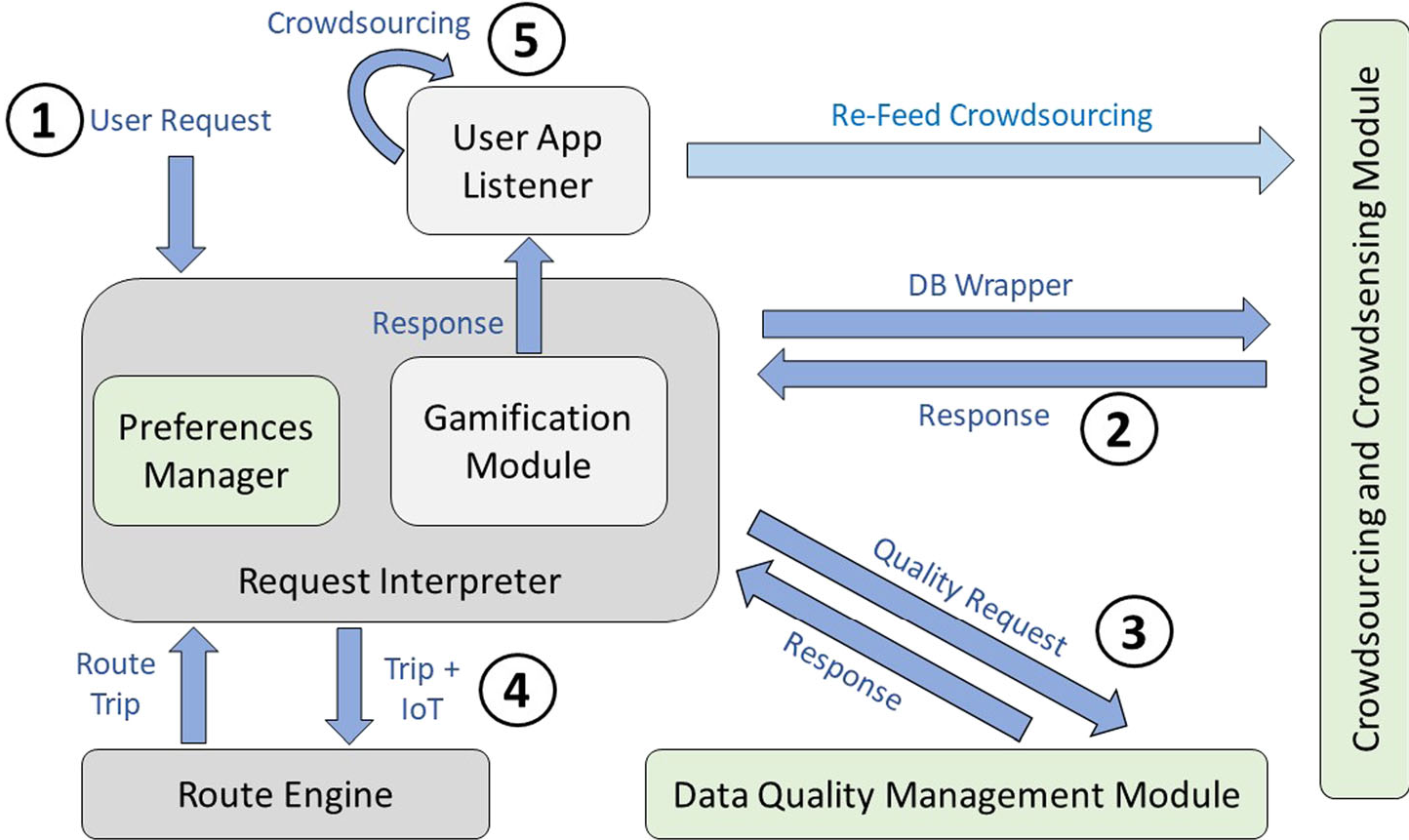
Central to the system is a Preferences Layer that acts as an interceptor between the user's request and the routing engine. It utilizes the MyData philosophy, ensuring personal data is stored in a Personal Data Vault (PDV). The system only accesses necessary snippets of information to calculate preferences, enhancing privacy.
The 5-Phase Execution Cycle:
- Request & Preference Analysis: Gathering user constraints (time, interests).
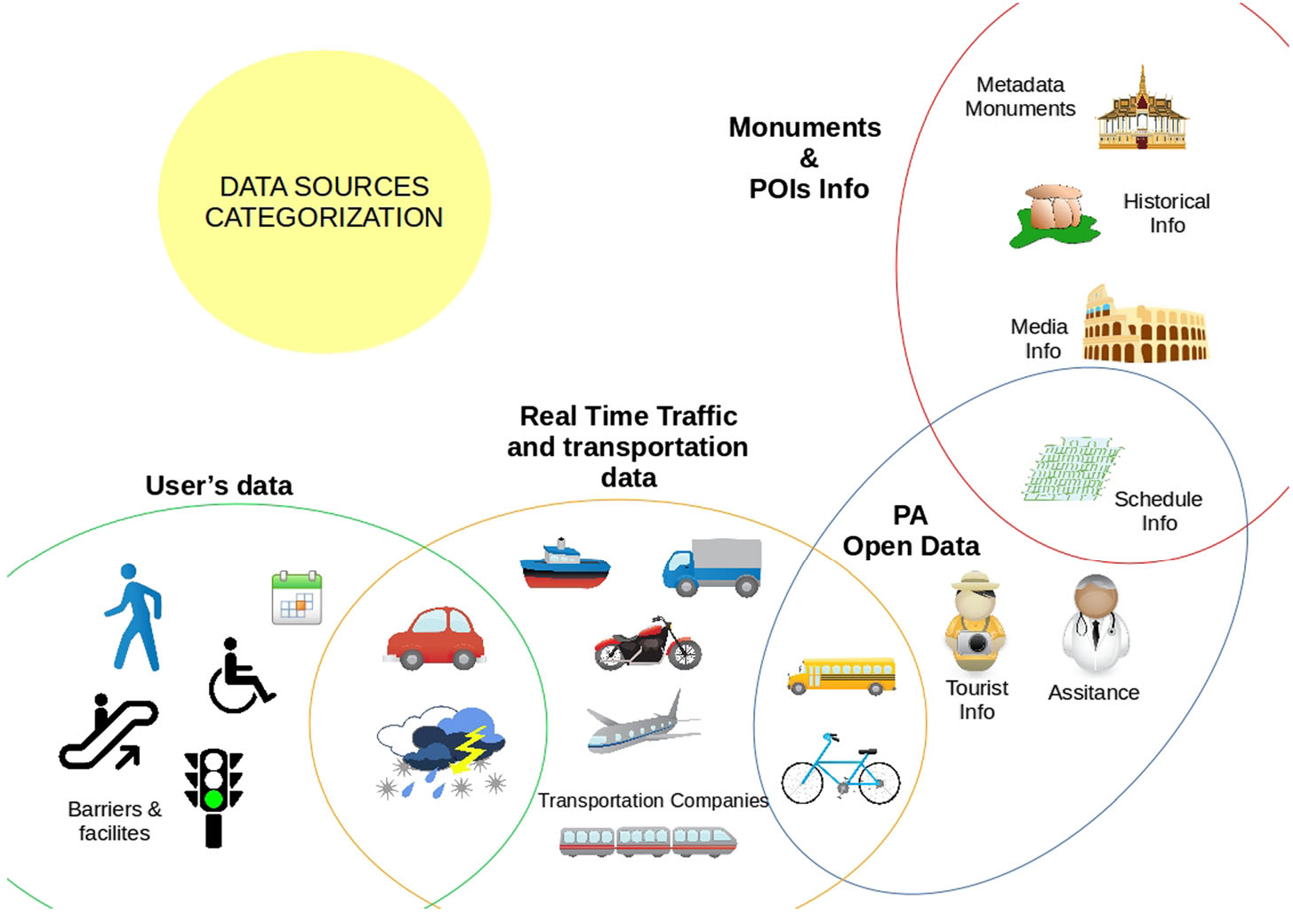
- POI Calculation: Querying official (SACHER project) and unofficial datasets to identify POIs with missing info.
- Routing: Using OpenTripPlanner (OTP) to weave these POIs into a cohesive path.
- Presentation & Gamification: Displaying the map where POIs with missing data are flagged as "point-earning opportunities."
- Re-feed: Validating and feeding crowdsourced data back into the system.
Gamification: The Mechanics of Contribution
To move users from passive viewing to active reporting, CICE (Collaborate, Learn, Share, Explore) implements four classic game mechanics:
- Points: Awarded for every photo, review, or tag.
- Achievements: Milestone rewards (e.g., "10 photos uploaded").
- Badges: Indicators of mastery or specific skills.
- Leaderboards: Global rankings to foster a sense of community competition.
Experiments: Real-world Validation in Cesena
The researchers conducted an "experience prototyping" session in Cesena, Italy. Participants were tasked with navigating from the Department of Engineering to the Bonci Theater, passing through history-rich spots like the Malatestiana Library.
Key Results:
- Enjoyment: 19 out of 20 users rated the interface and POI visualization as clear and engaging.
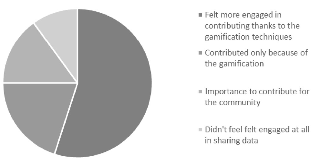
- Motivation: While some users would contribute altruistically, a significant portion (55%) noted that gamification directly increased their contribution frequency.
- Efficiency: The system successfully personalized paths based on specific "personas" (e.g., "John," who wanted a 2-hour walk focused on fountains and pasta).
Depth Insight: Why This Works
The brilliance of this work isn't just in the app, but in the feedback loop. By marking "POIs with missing features" on a map, the system creates a spatial prompt. Unlike general social media tagging, this is purposeful crowdsourcing. It solves the "cold start" problem of data collection by guiding users exactly where the data gaps are.
Critical Analysis & Future Work
While the prototype is successful, the authors acknowledge the need for "Games with a Purpose" (GWAP) to further refine data quality. A potential limitation is data validation—how do we ensure a user-submitted photo or accessibility tag is accurate? Future iterations plan to move toward a Software as a Service (SaaS) model, potentially integrating deeper with IoT urban infrastructure.
Takeaway: The CICE project proves that the future of smart cities isn't just about sensors in the ground; it's about the sensors in our pockets and the psychological triggers that make us want to use them for the common good.